Data Series 374
By Keith A. Labay and Peter J. Haeussler
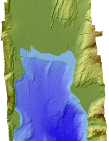
A new Digital Elevation Model was created using the best available high-resolution topography and multibeam bathymetry surrounding the area of Seward, Alaska. Datasets of (1) LIDAR topography collected for the Kenai Watershed Forum, (2) Seward harbor soundings from the U.S. Army Corp of Engineers, and (3) multibeam bathymetry from the National Oceanic and Atmospheric Administration contributed to the final combined product. These datasets were placed into a common coordinate system, horizontal datum, vertical datum, and data format prior to being combined. The projected coordinate system of Universal Transverse Mercator Zone 6 North American Datum of 1927 was used for the horizontal coordinates. Z-values in meters were referenced to the tidal datum of Mean High Water. Gaps between the datasets were interpolated to create the final seamless 5-meter grid covering the area of interest around Seward, Alaska.
Abstract
Introduction
Data Sources and Processing
Combined Dataset
Summary
References Cited
| File Name | Description | Metadata |
|---|---|---|
| sewardds_dem.zip (10.8 MB) | Combined DEM in ARC/INFO grid format | Text (20 KB), HTML (28 KB), FAQ (24 KB) |
| sewards_xyz.zip (23.3 MB) | Combined DEM in XYZ format | Text (20 KB), HTML (28 KB), FAQ (24 KB) |
| sewardds_geotiff.zip (11.6 MB) | Combined DEM in GeoTIFF format | Text (20 KB), HTML (28 KB), FAQ (24 KB) |
This report is available online in Portable Document Format (PDF). If you do not have the Adobe Reader, it is available for free download from Adobe Systems Incorporated.
Document Accessibility: Adobe Systems Incorporated has information about PDFs and the visually impaired. This information provides tools to help make PDF files accessible. These tools convert Adobe PDF documents into HTML or ASCII text, which then can be read by a number of common screen-reading programs that synthesize text as audible speech. In addition, an accessible version of Adobe Reader 8.0 for Windows (English only), which contains support for screen readers, is available. These tools and the accessible reader may be obtained free from Adobe at Adobe Access.
Send questions or comments about this report to the author, K.A. Labay, (907) 786-7410.
For more information about USGS activities in Alaska, visit the USGS Alaska Science Center home page.

![]() U.S. Department of the Interior | U.S. Geological Survey
U.S. Department of the Interior | U.S. Geological Survey
URL: https://pubs.usgs.gov/ds/374
Page Contact Information: Publications Team
Page Last Modified:Monday, 28-Nov-2016 13:05:12 EST
