Geographic Analysis and Monitoring Program
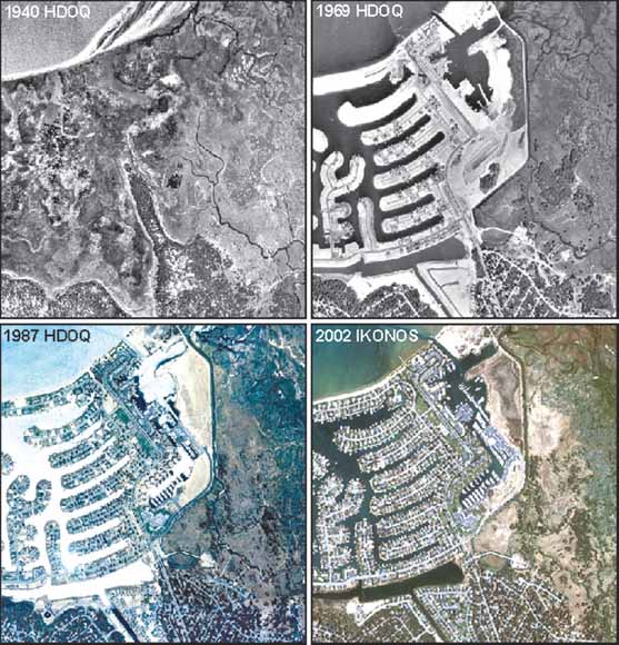
Historical digitial orthophotos (1940, 1969, 1987) and Ikonos imagery (2002) showing temporal land-cover change in South Lake Tahoe near the mouth of the Upper Truckee River.
The U.S. Geological Survey (USGS) Western Geographic Science Center has developed a series of historical digital orthoimagery (HDO) datasets covering part or all of the Lake Tahoe Basin. Three datasets are available: (A) 1940 HDOs for the southern Lake Tahoe Basin, (B) 1969 HDOs for the entire Lake Tahoe Basin, and (C) 1987 HDOs for the southern Lake Tahoe Basin. The HDOs (for 1940, 1969, and 1987) were compiled photogrammically from aerial photography with varying scales, camera characteristics, image quality, and capture dates. The resulting datasets have a 1-meter horizontal resolution. Precision-corrected Ikonos multispectral satellite imagery was used as a substitute for HDOs/DOQs for the 2002 imagery date, but these data are not available for download in this series due to licensing restrictions. The projection of the HDO data is set to UTM Zone 10, NAD 1983. The data for each of the three available dates are clipped into files that spatially approximate the 3.75-minute USGS quarter quadrangles (roughly 3,000 to 4,000 hectares), and have roughly 100 pixels (or 100 meters) of overlap to facilitate combining the files into larger regions without data gaps. The files are named after 3.75-minute USGS quarter quadrangles that cover the same general spatial extent. These files are available in the ERDAS Imagine (.img) format.
Download text of this report as a 14-page PDF file (ds376_text.pdf; 7.4 MB with links to 3.5 GB of data)
Go to the Metadata folder (metadata; 2 files, 48 kB total)
Go to the Data folder (data; 81 files, 3.5 GB total).
For questions about the content of this report, contact Chris Soulard.
Suggested citation and version history
Download a free copy of the latest version of Adobe Reader.
|
Help |
PDF help |
Publications main page |
| Western Data Series Reports |
| Geography | Geographic Analysis and Monitoring Program
|

![]() U.S. Department of the Interior | U.S. Geological Survey
U.S. Department of the Interior | U.S. Geological Survey
URL: https://pubs.usgs.gov/ds/376/
Page Contact Information: Michael Diggles
Page Created: September 25, 2008
Page Last Modified: October 28, 2008
(mfd)