U.S. Geological Survey Data Series 421
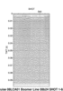
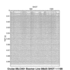
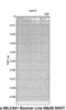
Below are thumbnail images of each line with links to full-size printable and interactive seismic reflection profiles. The printable profiles are GIF images that were filtered and gained using Seismic Unix software. These images are stored in the PRINTABLE folder. Refer to the Software page for details about the processing and examples of the processing scripts. The processed SEG-Y data were exported to CTI SonarWeb software to produce interactive versions of the profiles that allow the user to obtain a geographic location and depth for a cursor position on the profile. This information is displayed in the status bar of the browser. The interactive profiles, which are stored in the INTERACTIVE folder, have been corrected for the offset between the shotpoint and GPS antenna (see fig. 1).
The Trout Lake map illustrates the locations of the interactive and printable profiles presented below.
Table 2 lists trackline statistics for 08LCA01.
NOTE: The only supported Web browsers that properly display all features of the interactive profiles are Internet Explorer 6 or greater for Windows and Firefox 1.5 or greater for all platforms. Use of other browsers may result in spurious or no information given in the status window. Firefox may be downloaded at http://www.mozilla.org/products/firefox.
Browser setup for viewing interactive profiles:
For all browsers, the status bar and JavaScript must be enabled. Firefox also requires "Change status bar text" to be checked under Advanced JavaScript Options.
If using Internet Explorer 7, Active Content/ActiveX controls must be disabled. Instructions for doing this can be found by clicking on the "details and setup" link on the interactive profile pages.
SEG-Y Format
How to Download SEG-Y Data
FGDC Metadata
Additional Seismic Profile Pages:
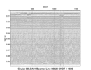
Line: 08b20 3642 traces:
Start of line: 08b20 SHOT=1 day=134 hour=14 minute=57 sec=0
End of Line: 08b20 SHOT=3642 day=134 hour=15 minute=12 sec=30
INTERACTIVE | PRINTABLE
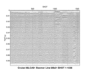
Line: 08b21 5600 traces:
Start of line: 08b21 SHOT=1 day=134 hour=15 minute=13 sec=38
End of Line: 08b21 SHOT=5600 day=134 hour=15 minute=37 sec=14
INTERACTIVE | PRINTABLE
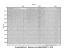
Line: 08b22 1670 traces:
Start of line: 08b22 SHOT=1 day=85 hour=13 minute=37 sec=46
End of line: 08b22 SHOT=1670 day=85 hour=13 minute=51 sec=41
INTERACTIVE | PRINTABLE
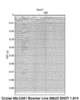
Line: 08b23 814 traces:
Start of line: 08b23 SHOT=1 day=85 hour=13 minute=51 sec=41
End of line: 08b23 SHOT=814 day=85 hour=13 minute=58 sec=28
INTERACTIVE | PRINTABLE
Line: 08b24 687 traces:
Start of line: 08b24 SHOT=1 day=85 hour=13 minute=58 sec=28
End of line: 08b24 SHOT=687 day=85 hour=14 minute=4 sec=11
INTERACTIVE | PRINTABLE
Line: 08b25 1199 traces:
Start of line: 08b25 SHOT=1 day=85 hour=14 minute=4 sec=12
End of line: 08b25 SHOT=1199 day=85 hour=14 minute=14 sec=11
INTERACTIVE | PRINTABLE
Line: 08b26 544 traces:
Start of line: 08b26 SHOT=1 day=85 hour=14 minute=14 sec=11
End of line: 08b26 SHOT=544 day=85 hour=14 minute=18 sec=43
INTERACTIVE | PRINTABLE

![]() U.S. Department of the Interior |
U.S. Geological Survey
U.S. Department of the Interior |
U.S. Geological Survey
URL: pubsdata.usgs.gov/pubs/ds/421/html/profiles_trout.html
Page Contact Information: Feedback
Page Last Modified: March 26, 2009 17:37 EST
