U.S. Geological Survey Data Series 425
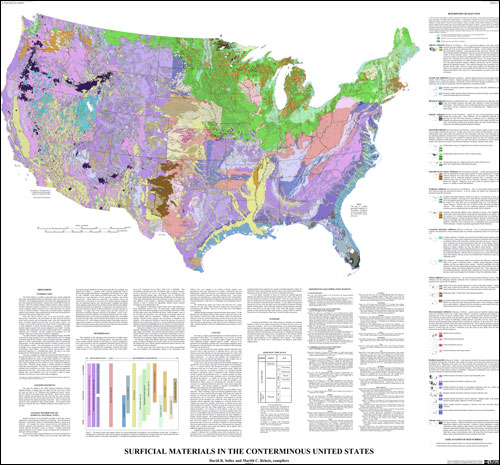
AbstractThe Earth's bedrock is overlain in many places by a loosely compacted and mostly unconsolidated blanket of sediments in which soils commonly are developed. These sediments generally were eroded from underlying rock, and then were transported and deposited. In places, they exceed 1000 ft (330 m) in thickness. Where the sediment blanket is absent, bedrock is either exposed or has been weathered to produce a residual soil. For the conterminous United States, a map by Soller and Reheis (2004, scale 1:5,000,000; https://pubs.usgs.gov/of/2003/of03-275/) shows these sediments and the weathered, residual material; for ease of discussion, these are referred to as "surficial materials." That map was produced as a PDF file, from an Adobe Illustrator-formatted version of the provisional GIS database. The provisional GIS files were further processed without modifying the content of the published map, and are here published. PurposeThe USGS National Cooperative Geologic Mapping Program (NCGMP) works with the State geological surveys to identify priority areas for mapping of surficial materials (for example, in areas of complex and poorly understood deposits of various sediment types, where metropolitan areas are experiencing rapid growth). To help establish these priorities, a quickly prepared, modern, synoptic overview of the geology was needed. The Soller and Reheis (2004) map was made in response to that need, and provides an overview of current knowledge of the composition and distribution of surficial materials in the conterminous United States. The map also serves to illustrate for educational and planning purposes the general nature and distribution of the Nation's surficial materials at land surface, but does not offer information useful for local decisions because it is not intended to be used at a larger (greater detail) scale than 1:5,000,000. Please refer to the map's "Methodology" and "Caveats" section, and to this database's metadata, for details on how this map was compiled, and practical limitations on its use. |
First posted June 5, 2009
This report is available only on the Web. For additional information, or to request geospatial data in a legacy format contact: Part of this report is presented in Portable Document Format (PDF); at least version 7 of Adobe Reader or similar software is required to view it. Download the latest version of Adobe Reader, free of charge. |
Soller, D.R., Reheis, M.C., Garrity, C.P., and Van Sistine, D.R., 2009, Map database for surficial materials in the conterminous United States: U.S. Geological Survey Data Series 425, scale 1:5,000,000 [https://pubs.usgs.gov/ds/425/].

![]() U.S. Department of the Interior |
U.S. Geological Survey
U.S. Department of the Interior |
U.S. Geological Survey
URL: http://pubsdata.usgs.gov/pubs/ds/425/index.html
Page Contact Information: GS Pubs Web Contact
Page Last Modified: Monday, 28-Nov-2016 14:33:34 EST
