Valentine, Page C. , 2009, Quadbnd.shp: Digital polygons of 18 individual quadrangles for the Stellwagen Bank National Marine Sanctuary region.: U.S. Geological Survey Data Series 469, Version 1.0, U. S. Geological Survey, Coastal and Marine Geology Program, Woods Hole Science Center, Woods Hole, MA.This is part of the following larger work.Online Links:
Valentine, Page C. , Gallea, Leslie B. , Blackwood, Dann S. , and Twomey, Erin R. , 2009, Seabed Photographs, Sediment Texture Analyses, and Sun-illuminated Sea Floor Topography in the Stellwagen Bank National Marine Sanctuary Region off Boston, Massachusetts Stellwagen Bank National Marine Sanctuary region off Boston, Massachusetts: U.S. Geological Survey Data Series 469, Version 1.0, U. S. Geological Survey, Coastal and Marine Geology Program, Woods Hole Science Center, Woods Hole, MA.Online Links:
This is a Vector data set. It contains the following vector data types (SDTS terminology):
Horizontal positions are specified in geographic coordinates, that is, latitude and longitude. Latitudes are given to the nearest 0.000001. Longitudes are given to the nearest 0.000001. Latitude and longitude values are specified in Decimal degrees.
The horizontal datum used is North American Datum of 1983.
The ellipsoid used is Geodetic Reference System 80.
The semi-major axis of the ellipsoid used is 6378137.000000.
The flattening of the ellipsoid used is 1/298.257222.
Sequential unique whole numbers that are automatically generated.
Coordinates defining the features.
| Range of values | |
|---|---|
| Minimum: | 1 |
| Maximum: | 18 |
| Units: | integer count |
| Resolution: | 1 |
| Range of values | |
|---|---|
| Minimum: | 77.855232 |
| Maximum: | 78.790718 |
| Units: | Kilometers |
| Resolution: | .000001 |
| Range of values | |
|---|---|
| Minimum: | 375.692177 |
| Maximum: | 379.292644 |
| Units: | Kilometers |
| Resolution: | .000001 |
(508) 548-8700 x2239 (voice)
(508) 457-2310 (FAX)
pvalentine@usgs.gov
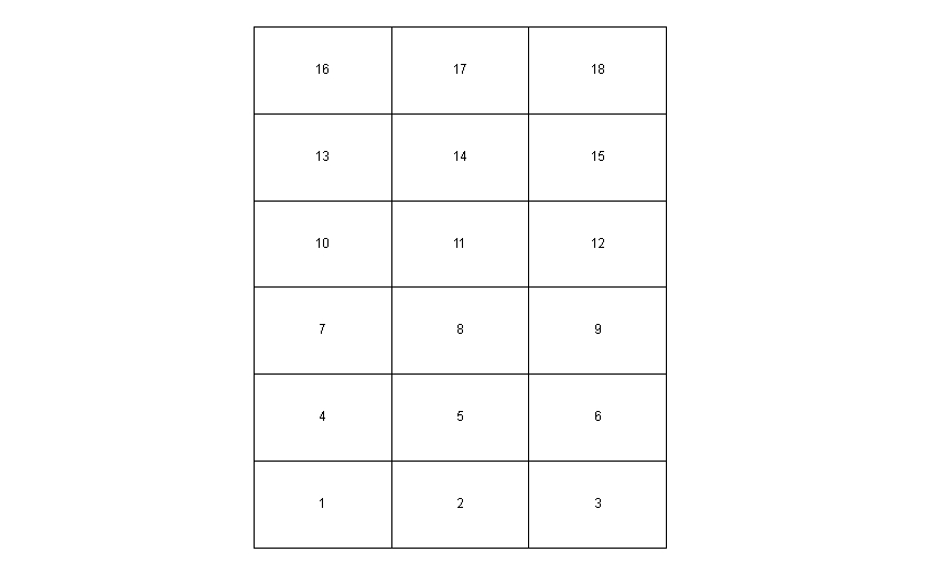
The map area is a composite of 18 individual quadrangle maps that represent a total area of 1,100 square nautical miles in the Stellwagen Bank National Marine Sanctuary region. The quadrangles are numbered 1 though 18, beginning in the southwest corner of the map region and increasing from left to right. The dimensions of the map area of each quadrangle are approximately 8 nm east-to-west and 7 nm north-to-south. The map region was subdivided into these 18 quadrangles so that high-resolution maps at a scale of 1:25,000 could be presented in both paper and digital format at a size convenient for the user.
Person who carried out this activity:
(508) 548-8700 x2239 (voice)
(508) 457-2310 (FAX)
pvalentine@usgs.gov
Page C. Valentine, editor, 2005, Sea floor image maps showing topography, sun-illuminated topography, backscatter intensity, ruggedness, slope, and the distribution of boulder ridges and bedrock outcrops in the Stellwagen Bank National Marine Sanctuary region off Boston, Massachusetts: Scientific Investigations Map 2840, U.S. Geological Survey, Coastal and Marine Geology Program, Woods Hole Coastal and Marine Science Center, Woods Hole, MA.Online Links:
The shapefile was opened in ArcMap 9.3 to check that its bounding coordinates matched those of the study area in the Stellwagen Bank National Marine Sanctuary region.
The geographic locations are accurate to 5 meters.
The depths are accurate to +/- 0.5 meters.
This shapefile has the locations of the 18 quadrangles drawn to represent the study area of the Stellwagen Bank National Marine Sanctuary region.
No other checks for topological consistency were preformed on this data.
Are there legal restrictions on access or use of the data?
- Access_Constraints: none
- Use_Constraints:
- Public Domain data from the U.S. Government are freely redistributed with proper metadata and source attribution. Please recognize the U.S. Geological Survey (USGS) as the source of this information.
(508) 548-8700 x2239 (voice)
(508) 457-2310 (FAX)
pvalentine@usgs.gov
Downloadable Data
Neither the U.S. Government, the Department of the Interior, nor the USGS, nor any of their employees, contractors, or subcontractors, make any warranty, express or implied, nor assume any legal liability or responsibility for the accuracy, completeness, or usefulness of any information, apparatus, product, or process disclosed, nor represent that its use would not infringe on privately owned rights. The act of distribution shall not constitute any such warranty, and no responsibility is assumed by the USGS in the use of these data or related materials. Any use of trade, product, or firm names is for descriptive purposes only and does not imply endorsement by the U.S. Government.
| Data format: | Shapefile and associated metadata in format WinZip Size: 0.002 |
|---|---|
| Network links: |
U.S. Geological Survey |
| Media you can order: |
DVD-ROM
(Density 4.75
Gbytes)
(format UDF)
|
These data are available in Environmental Systems Research Institute (ESRI) shapefile format. The user must have ArcGIS® or ArcView® 3.0 or greater software to read and process the data file. In lieu of ArcView or ArcGIS, the user may utilize another GIS application package capable of the importing data. A free data viewer, ArcExplorer, capable of displaying the data is available from ESRI at www.esri.com. The data is available to download in WinZip format that was created with WinZip Version 9.0 SR-1 (6224).
(508) 548-8700 x2341 (voice)
(508) 457-2310 (FAX)
lgallea@usgs.gov