U.S. Geological Survey Data Series 535A
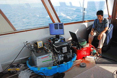
MICA: Sample water was drawn continuously from a sampling port set approximately 1 meter (m) below the waterline near the center of the vessel (fig. 3). A flow-through system consisting of 4 m of insulated Tygon tubing connected to a peristaltic metering pump was used to draw water from the port to the MICA apparatus at a flow rate of approximately 1 liter per minute. The tubing was routed through a conductivity - temperature - depth (CTD) profiler sonde integral to the MICA, and the profiler logged water temperature and salinity parameters.
 |
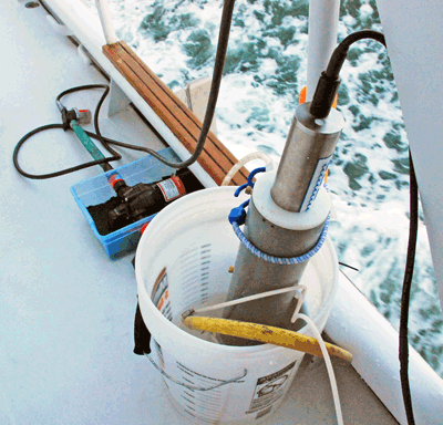
A CTD sonde was deployed on cruises in 2008 and 2009 to provide temperature and salinity values for water chemistry calculations (CTD2). This CTD was located 2 m above the waterline, amidship, and was supplied water via a pump system. During the 2009 cruises, an additional YSI 6600 CTD Sonde (fig. 4) was used and was located at the stern of the vessel (CTD1). This sonde was located 50 cm above the waterline and was supplied using the hydraulic head in a 1-cm pipe while the vessel was underway. When possible, the salinity and temperature values recorded by CTD1 were used for water chemistry calculations. The secondary CTD sonde deployed on all cruises was used for replication purposes (CTD2). Although methods presented here describe data collection for multiple cruises in 2008 and 2009, each data release represents data from a single cruise.
 |
DISCRETE WATER SAMPLES: Discrete water samples (fig. 5) were collected underway to corroborate the continuous pCO2 measurements. Samples were collected in 500-mL borosilicate bottles and poisoned with 100 μL of saturated mercuric chloride solution. Stoppers were treated with Apiezon® L grease to ensure an airtight seal. Water samples were analyzed for salinity, pH (±0.002), and total alkalinity (±1.0 μmol kg-1 SW) at the USGS geochemistry laboratory in St. Petersburg, Florida, using Ocean Optics spectrophotometers and the methods of Zhang and Byrne (1996) and Yao and Byrne (1998), respectively. CO2SYS, a computer program developed by Pierrot and others (2006), was used to corroborate discrete sample data with continuous flow through data, using dissociation constants K1 and K2 from Mehrbach and others (1973) refit by Dickson and Millero (1987). Constants for KHSO4 came from Dickson (1990) and total pH scale was used. Total carbon (3 μmol kg-1 SW) was measured using a UIC, Inc. carbon coulometer using methods of Dickson and others (2007).
 |
Supplemental temperature and salinity measurements were made periodically using a Digi-Sense® ThermoLogR RTD thermometer and a Horiba ES-51 salinity meter. Clock times for all apparatus were synchronized prior to the voyage and daily thereafter. A Garmin GPS recorded the time and location of the vessel one to two times per minute.
DATA INTEGRATION: The raw MICA and GPS data were separated into text files by date to facilitate processing. Time fields were converted to seconds-after-midnight to facilitate merging of computing routines. A Python script was used to join the MICA and GPS data values into one file; the MICA value was assigned to the most recently available GPS value. This newly generated MICA-GPS file was then joined with the YSI 6600 Sonde data in a similar fashion (2009 data only).
ADJUSTMENT OF SONDE SALINITY (S) VALUES: The YSI 6600 was calibrated against CRM 76, salinity=34.835 (Dickson, 2006). As a result, a calibration factor of 0.745 was added to all sonde salinity values.
ANALYSIS OF TEMPERATURE AND SALINITY DATA: All sonde salinity and temperature data were evaluated. If a value differed by more than 10 percent from the preceding value, was not present, or was clearly incorrect, the value was discarded and replaced as described below.
If the sonde salinity value was discarded, it was replaced by the most recent correct value. If a continuous series of salinity values was discarded, it was replaced with values generated by a linear interpolation between the acceptable values immediately preceding and following the discarded range.
The secondary sonde (CTD2) temperature differed from the primary sonde temperature because of environmental effects and was adjusted (on 2009 cruises) by applying a correction factor generated by taking the mean of the differences between the last usable primary sonde temperature value and the corresponding secondary sonde value and the next usable primary sonde temperature value and the corresponding secondary sonde value. If the primary sonde (CTD1) temperature value was unavailable or discarded, the secondary sonde (CTD2) temperature was used. If secondary sonde temperature values were not available, the incorrect temperature values were replaced with the most recent correct values.
CORRECTION OF MICA pH VALUE USING SALINITY: The now-correct salinity values were used to correct the pH value recorded by the MICA. The corrected salinity and the pH ratio values were used to calculate the correct pH, which was copied to the "Corrected pH" column (Zhang and Byrne, 1996).
CORRECTION OF MICA TC VALUE USING SALINITY: Similarly, the now-correct salinity values were used to correct the total carbon (TC) value recorded by the MICA. The corrected salinity and the TC ratio values were used to calculate the correct TC, which was copied to the "Corrected TC" column (Byrne and others, 2002).

![]() U.S. Department of the Interior |
U.S. Geological Survey
U.S. Department of the Interior |
U.S. Geological Survey
URL: pubsdata.usgs.gov/pubs/ds/535/a/html/methods.html
Page Contact Information: Feedback
Page Last Modified: Monday, 28-Nov-2016 15:35:43 EST
