 Introduction Introduction
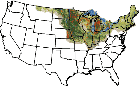
U.S. Geological Survey (USGS) Miscellaneous Investigations Series Map I-1970 is a 1:1,000,000-scale map of Quaternary deposits (including both glacial and glacially related sediments, and any overlying Holocene sediments) compiled for the glaciated area of the United States east of the Rocky Mountains (that is, the area covered by the Laurentide ice sheets). It is a regional synthesis and interpretation of available geologic data derived from about 850 sources of information. The map has four principal geologic components that together provide the first regional three-dimensional view of these deposits. These components are: (1) the surface distribution of Quaternary sediments; (2) the total thickness of Quaternary sediments; (3) significant thin, surficial Quaternary units ("veneers" of sediment overlying the unit generally mapped for a given area); and (4) significant buried Quaternary sediments.
Published in four sheets between 1993 and 1998, Map I-1970 also was released in GIS format (ArcInfo v.7), in 1998. With gradual advances in GIS technology, and owing to continued user requests for the map database, it became incumbent on us to reprocess the database in order to ensure its usefulness in a modern GIS. This publication contains the updated database, organized in ten feature classes in an ESRI Geodatabase.
Regarding the use of this product, as noted in the descriptive text for Map I-1970:
"This map is a regional overview and is intended to supplement the more detailed work on which it is based. Particularly in populated areas, detailed mapping is vital to site-specific planning. In contrast, regional maps such as this serve to place local, detailed mapping in context, to permit the extrapolation of data into unmapped areas, and to depict large-scale regional geologic features and patterns that are beyond the scope of local, detailed mapping. This map is also intended as a regional planning document that can assist in setting priorities for areas in need of more detailed mapping and assessment."
|
First posted March 26, 2012
Part or all of this report is presented in Portable Document Format (PDF); the latest version of Adobe Reader or similar software is required to view it. Download the latest version of Adobe Reader, free of charge. |

