U.S. Geological Survey Data Series 709
|
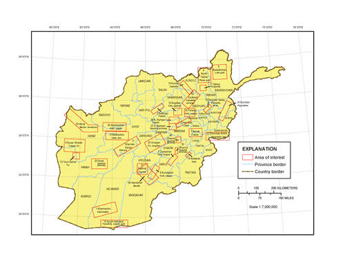
SummaryThe U.S. Geological Survey (USGS), in cooperation with the U.S. Department of Defense Task Force for Business and Stability Operations, prepared databases for mineral-resource target areas in Afghanistan. The purpose of the databases is to (1) provide useful data to ground-survey crews for use in performing detailed assessments of the areas and (2) provide useful information to private investors who are considering investment in a particular area for development of its natural resources. The set of satellite-image mosaics provided in this Data Series (DS) is one such database. Although airborne digital color-infrared imagery was acquired for parts of Afghanistan in 2006, the image data have radiometric variations that preclude their use in creating a consistent image mosaic for geologic analysis. Consequently, image mosaics were created using ALOS (Advanced Land Observation Satellite; renamed Daichi) satellite images, whose radiometry has been well determined (Saunier, 2007a,b). This DS consists of the locally enhanced ALOS image mosaics for each of the 32 mineral project areas (referred to herein as areas of interest), whose locality names, locations, and main mineral occurrences are shown on the index map of Afghanistan (fig. 1). ALOS was launched on January 24, 2006, and provides multispectral images from the AVNIR (Advanced Visible and Near-Infrared Radiometer) sensor in blue (420–500 nanometer, nm), green (520–600 nm), red (610–690 nm), and near-infrared (760–890 nm) wavelength bands with an 8-bit dynamic range and a 10-meter (m) ground resolution. The satellite also provides a panchromatic band image from the PRISM (Panchromatic Remote-sensing Instrument for Stereo Mapping) sensor (520–770 nm) with the same dynamic range but a 2.5-m ground resolution. The image products in this DS incorporate copyrighted data provided by the Japan Aerospace Exploration Agency, but the image processing has altered the original pixel structure and all image values of the JAXA ALOS data, such that original image values cannot be recreated from this DS. As such, the DS products match JAXA criteria for value added products, which are not copyrighted, according to the ALOS end-user license agreement. The selection criteria for the satellite imagery used in our mosaics were images having (1) the highest solar-elevation angles (near summer solstice) and (2) the least cloud, cloud-shadow, and snow cover. The multispectral and panchromatic data were orthorectified with ALOS satellite ephemeris data, a process which is not as accurate as orthorectification using digital elevation models (DEMs); however, the ALOS processing center did not have a precise DEM. As a result, the multispectral and panchromatic image pairs were generally not well registered to the surface and not coregistered well enough to perform resolution enhancement on the multispectral data. Therefore, it was necessary to (1) register the 10-m AVNIR multispectral imagery to a well-controlled Landsat image base, (2) mosaic the individual multispectral images into a single image of the entire area of interest, (3) register each panchromatic image to the registered multispectral image base, and (4) mosaic the individual panchromatic images into a single image of the entire area of interest. The two image-registration steps were facilitated using an automated control-point algorithm developed by the USGS that allows image coregistration to within one picture element. PRISM image orthorectification for one-half of the target areas was performed by the Alaska Satellite Facility, applying its photogrammetric software to PRISM stereo images with vertical control points obtained from the digital elevation database produced by the Shuttle Radar Topography Mission (Farr and others, 2007) and horizontal adjustments based on a controlled Landsat image base (Davis, 2006). Before rectification, the multispectral and panchromatic images were converted to radiance values and then to relative-reflectance values using the methods described in Davis (2006). Mosaicking the multispectral or panchromatic images started with the image with the highest sun-elevation angle and the least atmospheric scattering, which was treated as the standard image. The band-reflectance values of all other multispectral or panchromatic images within the area were sequentially adjusted to that of the standard image by determining band-reflectance correspondence between overlapping images using linear least-squares analysis. The resolution of the multispectral image mosaic was then increased to that of the panchromatic image mosaic using SPARKLE logic, which is described in Davis (2006). Each of the four-band images within each resolution-enhanced image mosaic was individually subjected to a local-area histogram stretch algorithm (described in Davis, 2007), which stretches each band’s picture element based on the digital values of all picture elements within a specified radius that was usually 500 m. The final databases, which are provided in this DS, are three-band, color-composite images of the local-area-enhanced, natural-color data (the blue, green, and red wavelength bands) and color-infrared data (the green, red, and near-infrared wavelength bands). All image data were initially projected and maintained in Universal Transverse Mercator (UTM) map projection using the target area’s local zone (either 41 or 42) and the WGS84 datum. Most final image mosaics were subdivided into overlapping tiles or quadrants because of the large size of the target areas. The image tiles (or quadrants) for each area of interest are provided as embedded geotiff images, which can be read and used by most geographic information system (GIS) and image-processing software. The tiff world files (tfw) are provided, even though they are generally not needed for most software to read an embedded geotiff image. Approximately one-half of the study areas have at least one subarea designated for detailed field investigations; the subareas were extracted from the area’s image mosaic and are provided as separate embedded geotiff images. References CitedDavis, P.A., 2006, Calibrated Landsat ETM+ nonthermal-band image mosaics of Afghanistan: U.S. Geological Survey Open-File Report 2006–1345, 18 p., available at https://pubs.usgs.gov/of/2006/1345/. Davis, P.A., 2007, Landsat ETM+ false-color image mosaics of Afghanistan: U.S. Geological Survey Open-File Report 2007–1029, 22 p., available at https://pubs.usgs.gov/of/2007/1029/. Farr, T.G., Rosen, P.A., Caro, E., Crippen, R., Duren, R., Hensley, S., Kobrick, M., Paller, M., Rodriguez, E., Roth, L., Seal, D., Shaffer, S., Shimada, J., Umland, J., Werner, M., Oskin, M., Burbank, D., and Alsdorf, D., 2007, The Shuttle Radar Topography Mission: Reviews of Geophysics, v. 45, RG2004, 33 p., doi:10.1029/2005RG000183. Peters, S.G., King, T.V.V., Mack, T.J., and Chornack, M.P., eds., and the U.S. Geological Survey Afghanistan Mineral Assessment Team, 2011, Summaries of important areas for mineral investment and production opportunities of nonfuel minerals in Afghanistan: U.S. Geological Survey Open-File Report 2011–1204, 1,810 p. plus appendixes on DVD. (Also available at https://pubs.usgs.gov/of/2011/1204/). Saunier, S., 2007a, Final calibration/validation report, PRISM: GAEL Consultant report, 27 p., accessed April 23, 2012, at http://earth.esa.int/pub/ESA_DOC/ALOS011.pdf. Saunier, S., 2007b, Final calibration/validation report, AVNIR-2: GAEL Consultant report, 25 p., accessed April 23, 2012, at http://earth.esa.int/pub/ESA_DOC/ALOS012.pdf. ChaptersData Series 709–A, Local-Area-Enhanced, 2.5-Meter Resolution Natural-Color and Color-Infrared Satellite-Image Mosaics of the Khanneshin Mineral District in Afghanistan by Philip A. Davis, Laura E. Cagney, Scott A. Arko, and Michelle L. Harbin. Data Series 709–B, Local-Area-Enhanced, 2.5-Meter Resolution Natural-Color and Color-Infrared Satellite-Image Mosaics of the Balkhab Mineral District in Afghanistan by Philip A. Davis and Laura E. Cagney. Data Series 709–C, Local-Area-Enhanced, 2.5-Meter Resolution Natural-Color and Color-Infrared Satellite-Image Mosaics of the Haji-Gak Mineral District in Afghanistan by Philip A. Davis, Laura E. Cagney, Scott A. Arko, and Michelle L. Harbin. Data Series 709–D, Local-Area-Enhanced, 2.5-Meter Resolution Natural-Color and Color-Infrared Satellite-Image Mosaics of the North Takhar Mineral District in Afghanistan by Philip A. Davis and Laura E. Cagney. Data Series 709–E, Local-Area-Enhanced, 2.5-Meter Resolution Natural-Color and Color-Infrared Satellite-Image Mosaics of the Aynak Mineral District in Afghanistan by Philip A. Davis, Laura E. Cagney, Scott A. Arko, and Michelle L. Harbin. Data Series 709–F, Local-Area-Enhanced, 2.5-Meter Resolution Natural-Color and Color-Infrared Satellite-Image Mosaics of the Badakhshan Mineral District in Afghanistan by Philip A. Davis, Scott A. Arko, and Michelle L. Harbin. Data Series 709–G, Local-Area-Enhanced, 2.5-Meter Resolution Natural-Color and Color-Infrared Satellite-Image Mosaics of the Zarkashan Mineral District in Afghanistan by Philip A. Davis and Laura E. Cagney. Data Series 709–H, Local-Area-Enhanced, 2.5-Meter Resolution Natural-Color and Color-Infrared Satellite-Image Mosaics of the Kundalyan Mineral District in Afghanistan by Philip A. Davis, Laura E. Cagney, Scott A. Arko, and Michelle L. Harbin. Data Series 709–I, Local-Area-Enhanced, 2.5-Meter Resolution Natural-Color and Color-Infrared Satellite-Image Mosaics of the Dusar-Shaida Mineral District in Afghanistan by Philip A. Davis, Scott A. Arko, and Michelle L. Harbin. Data Series 709–J, Local-Area-Enhanced, 2.5-Meter Resolution Natural-Color and Color-Infrared Satellite-Image Mosaics of the Tourmaline Mineral District in Afghanistan by Philip A. Davis, Laura E. Cagney, Scott A. Arko, and Michelle L. Harbin. Data Series 709–K, Local-Area-Enhanced, 2.5-Meter Resolution Natural-Color and Color-Infrared Satellite-Image Mosaics of the Kharnak-Kanjar Mineral District in Afghanistan by Philip A. Davis, Scott A. Arko, and Michelle L. Harbin. Data Series 709–L, Local-Area-Enhanced, 2.5-Meter Resolution Natural-Color and Color-Infrared Satellite-Image Mosaics of the Nalbandon Mineral District in Afghanistan by Philip A. Davis and Laura E. Cagney. Data Series 709–M, Local-Area-Enhanced, 2.5-Meter Resolution Natural-Color and Color-Infrared Satellite-Image Mosaics of the Panjsher Valley Mineral District in Afghanistan by Philip A. Davis and Laura E. Cagney. Data Series 709–N, Local-Area-Enhanced, 2.5-Meter Resolution Natural-Color and Color-Infrared Satellite-Image Mosaics of the Katawas Mineral District in Afghanistan by Philip A. Davis and Laura E. Cagney. Data Series 709–O, Local-Area-Enhanced, 2.5-Meter Resolution Natural-Color and Color-Infrared Satellite-Image Mosaics of the South Helmand Mineral District in Afghanistan by Philip A. Davis and Laura E. Cagney. Data Series 709–P, Local-Area-Enhanced, 2.5-Meter Resolution Natural-Color and Color-Infrared Satellite-Image Mosaics of the Baghlan Mineral District in Afghanistan by Philip A. Davis and Laura E. Cagney. Data Series 709–Q, Local-Area-Enhanced, 2.5-Meter Resolution Natural-Color and Color-Infrared Satellite-Image Mosaics of the Takhar Mineral District in Afghanistan by Philip A. Davis and Laura E. Cagney. Data Series 709–R, Local-Area-Enhanced, 2.5-Meter Resolution Natural-Color and Color-Infrared Satellite-Image Mosaics of the Dudkash Mineral District in Afghanistan by Philip A. Davis, Scott A. Arko, and Michelle L. Harbin. Data Series 709–S, Local-Area-Enhanced, 2.5-Meter Resolution Natural-Color and Color-Infrared Satellite-Image Mosaics of the Kunduz Mineral District in Afghanistan by Philip A. Davis, Scott A. Arko, and Michelle L. Harbin. Data Series 709–U, Local-Area-Enhanced, 2.5-Meter Resolution Natural-Color and Color-Infrared Satellite-Image Mosaics of the Bakhud Mineral District in Afghanistan by Philip A. Davis and Laura E. Cagney. Data Series 709–V, Local-Area-Enhanced, 2.5-Meter Resolution Natural-Color and Color-Infrared Satellite-Image Mosaics of the Uruzgan Mineral District in Afghanistan by Philip A. Davis. Data Series 709–W, Local-Area-Enhanced, 2.5-Meter Resolution Natural-Color and Color-Infrared Satellite-Image Mosaics of the Ghunday-Achin Mineral District in Afghanistan by Philip A. Davis, Scott A. Arko, and Michelle L. Harbin. Data Series 709–X, Local-Area-Enhanced, 2.5-Meter Resolution Natural-Color and Color-Infrared Satellite-Image Mosaics of the Nuristan Mineral District in Afghanistan by Philip A. Davis, Laura E. Cagney, Scott A. Arko, and Michelle L. Harbin. Data Series 709–Y, Local-Area-Enhanced, 2.5-Meter Resolution Natural-Color and Color-Infrared Satellite-Image Mosaics of the Ahankashan Mineral District in Afghanistan by Philip A. Davis. Data Series 709–Z, Local-Area-Enhanced, 2.5-Meter Resolution Natural-Color and Color-Infrared Satellite-Image Mosaics of the Kandahar Mineral District in Afghanistan by Philip A. Davis. Data Series 709–AA, Local-Area-Enhanced, 2.5-Meter Resolution Natural-Color and Color-Infrared Satellite-Image Mosaics of the South Bamyan Mineral District in Afghanistan by Philip A. Davis. Data Series 709–BB, Local-Area-Enhanced, 2.5-Meter Resolution Natural-Color and Color-Infrared Satellite-Image Mosaics of the North Bamyan Mineral District in Afghanistan by Philip A. Davis. Data Series 709–CC, Local-Area-Enhanced, 2.5-Meter Resolution Natural-Color and Color-Infrared Satellite-Image Mosaics of the Parwan Mineral District in Afghanistan by Philip A. Davis. Data Series 709–DD, Local-Area-Enhanced, 2.5-Meter Resolution Natural-Color and Color-Infrared Satellite-Image Mosaics of the Ghazni1 Mineral District in Afghanistan by Phillip A. Davis. Data Series 709–EE, Local-Area-Enhanced, 2.5-Meter Resolution Natural-Color and Color-Infrared Satellite-Image Mosaics of the Ghazni2 Mineral District in Afghanistan by Phillip A. Davis. Data Series 709–FF, Local-Area-Enhanced, 2.5-Meter Resolution Natural-Color and Color-Infrared Satellite-Image Mosaics of the Farah Mineral District in Afghanistan by Phillip A. Davis. |
Last modified May 7, 2014
Chapters
This report is available only on the Web. For additional information: Part of this report is presented in Portable Document Format (PDF); the latest version of Adobe Reader or similar software is required to view it. Download the latest version of Adobe Reader, free of charge. |
Davis, P.A., compiler, 2012, Local-area-enhanced, high-resolution natural-color and color-infrared satellite-image mosaics of mineral districts in Afghanistan: U.S. Geological Survey Data Series 709. (Available at https://pubs.usgs.gov/ds/709/.)

![]() U.S. Department of the Interior |
U.S. Geological Survey
U.S. Department of the Interior |
U.S. Geological Survey
URL: http://pubsdata.usgs.gov/pubs/ds/709/index.html
Page Contact Information: GS Pubs Web Contact
Page Last Modified: Monday, 28-Nov-2016 18:56:55 EST