Data Series 720
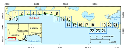
AbstractThese remotely sensed, geographically referenced color-infrared (CIR) imagery and elevation measurements of lidar-derived first-surface (FS) topography datasets were produced by the U.S. Geological Survey (USGS), St. Petersburg Coastal and Marine Science Center, St. Petersburg, Florida, and the National Aeronautics and Space Administration (NASA), Wallops Flight Facility, Virginia. This project provides highly detailed and accurate datasets of a portion of the Louisiana coastline beachface, acquired post-Hurricane Rita on September 27-28 and October 2, 2005. The datasets are made available for use as a management tool to research scientists and natural-resource managers. An innovative airborne lidar instrument originally developed at the National Aeronautics and Space Administration (NASA) Wallops Flight Facility, and known as the Experimental Advanced Airborne Research Lidar (EAARL), was used during data acquisition. The EAARL system is a raster-scanning, waveform-resolving, green-wavelength (532-nanometer) lidar designed to map near-shore bathymetry, topography, and vegetation structure simultaneously. The EAARL sensor suite includes the raster-scanning, water-penetrating full-waveform adaptive lidar, a down-looking red-green-blue (RGB) digital camera, a high-resolution multispectral color-infrared (CIR) camera, two precision dual-frequency kinematic carrier-phase GPS receivers, and an integrated miniature digital inertial measurement unit, which provide for sub-meter georeferencing of each laser sample. The nominal EAARL platform is a twin-engine Cessna 310 aircraft, but the instrument may be deployed on a range of light aircraft. A single pilot, a lidar operator, and a data analyst constitute the crew for most survey operations. This sensor has the potential to make significant contributions in measuring sub-aerial and submarine coastal topography within cross-environmental surveys. Elevation measurements were collected over the survey area using the EAARL system, and the resulting data were then processed using the Airborne Lidar Processing System (ALPS), a custom-built processing system developed in a NASA-USGS collaboration. ALPS supports the exploration and processing of lidar data in an interactive or batch mode. Modules for presurvey flight-line definition, flight-path plotting, lidar raster and waveform investigation, and digital camera image playback have been developed. Processing algorithms have been developed to extract the range to the first and last significant return within each waveform. ALPS is used routinely to create maps that represent submerged or sub-aerial topography. Specialized filtering algorithms have been implemented to determine the "bare earth" under vegetation from a point cloud of last return elevations. For more information about similar projects, please visit the Lidar for Science and Resource Management Website. |
First posted July 19, 2013
For additional information contact: Part or all of this report is presented in Portable Document Format (PDF); the latest version of Adobe Reader or similar software is required to view it. Download the latest version of Adobe Reader, free of charge. |
Bonisteel-Cormier, J.M., Wright, C.W., Fredericks, Xan, Klipp, E.S., Nagle, D.B., Sallenger, A.H., and Brock, J.C., 2013, EAARL coastal topography and imagery–Western Louisiana, post-Hurricane Rita, 2005: first surface: U.S. Geological Survey Data Series 720, 1 DVD, https://pubs.usgs.gov/ds/720.
Purpose
Metadata
Collaborators
Acronyms

![]() U.S. Department of the Interior |
U.S. Geological Survey
U.S. Department of the Interior |
U.S. Geological Survey
URL: http://pubsdata.usgs.gov/pubs/ds/720/index.html
Page Contact Information: GS Pubs Web Contact
Page Last Modified: Monday, 28-Nov-2016 19:15:23 EST

