U.S. Geological Survey Data Series 724
U.S. Geological Survey, St. Petersburg, FL 33701.
U.S. Department of the Interior
U.S. Geological Survey
St. Petersburg Coastal and Marine Science Center
Publications are available from USGS Information Services, Box 25286, Federal Center, Denver, Colo. 80225-0046 (telephone 1-888-ASK-USGS; e-mail: infoservices@usgs.gov).
Page Contents: |
||||
 |
||||
This Digital Versatile Disc (DVD) publication was prepared by an agency of the United States Government. Although these data have been processed successfully on a computer system at the U.S. Geological Survey, no warranty expressed or implied is made regarding the display or utility of the data on any other system, nor shall the act of distribution imply any such warranty. The U.S. Geological Survey shall not be held liable for improper or incorrect use of the data described and (or) contained herein. Reference herein to any specific commercial product, process, or service by trade name, trademark, manufacturer, or otherwise does not constitute or imply its endorsement, recommendation, or favoring by the United States Government or any agency thereof.
This disc is readable on any computing platform that has standard DVD driver software installed. The minimum software requirements are a Web browser, a portable document format (PDF) reader, and a text editor. If you cannot fully access the information on this page, please contact USGS Information Services at infoservices@usgs.gov or 1-888-ASK-USGS.
To access the information contained on this disc, use a Web browser to open the file index.html. This report is divided into seven sections: Acronyms and Abbreviations, Disc Contents, Navigation Data and Maps, Subbottom Profiles, Field Activity Logs, Federal Geographic Data Committee (FGDC) Metadata, and Software. Links at the top and bottom of each page provide access to these sections. This report contains links to the USGS and collaborators or other resources that are only accessible if access to the Internet is available while viewing these documents.
This disc contains a readme (2-KB text file) document, which provides a brief description of the report; a folder containing Society of Exploration Geophysicists (SEG) Y binary data files; Geographic Information System (GIS) files; and all the Hypertext Markup Language (HTML) files, folders, and images used to produce the Web pages included in this report. The Disc Contents page contains a diagram with locations and links to all files and folders contained on this disc.
In September of 2010, the U.S. Geological Survey (USGS), in cooperation with the U.S. Army Corps of Engineers (USACE), conducted a geophysical survey to investigate the geologic controls on barrier island framework of Cat Island, Miss., as part of a broader USGS study on Barrier Island Mapping (BIM). These surveys were funded through the Mississippi Coastal Improvements Program (MsCIP) and the Northern Gulf of Mexico (NGOM) Ecosystem Change and Hazard Susceptibility Project as part of the Holocene Coastal Evolution of the Mississippi-Alabama Region Subtask. This report serves as an archive of unprocessed digital chirp subbottom data, trackline maps, navigation files, GIS files, Field Activity Collection System (FACS) logs, and formal FGDC metadata. Gained (showing a relative increase in signal amplitude) digital images of the seismic profiles are also provided. Refer to the Acronyms page for expansions of acronyms and abbreviations used in this report.
The USGS Saint Petersburg Coastal and Marine Science Center (SPCMSC) assigns a unique identifier to each cruise or field activity. For example, 10BIM04 tells us the data were collected in 2010 during the fourth field activity for that project in that calendar year. Refer to http://walrus.wr.usgs.gov/infobank/programs/html/definition/activity.html for a detailed description of the method used to assign the field activity identification (ID).
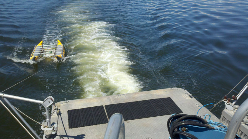
All chirp systems use a signal of continuously varying frequency; the EdgeTech SB-512i system used during this survey produces high-resolution, shallow-penetration (typically less than 50 milliseconds (ms)) profile images of sub-seafloor stratigraphy. The towfish contains a transducer that transmits and receives acoustic energy; it was housed within a float system (built at the SPCMSC), which allows the towfish to be towed at a constant depth of 1.07 meters (m) below the sea surface. As transmitted acoustic energy intersects density boundaries, such as the seafloor or sub-surface sediment layers, some energy is reflected back toward the transducer, received, and recorded by a Personal Computer (PC)-based seismic acquisition system. This process is repeated at regular time intervals (for example, 0.125 seconds (s)), and returned energy is recorded for a specific duration (for example, 50 ms). In this way, a two-dimensional (2-D) vertical image of the shallow geologic structure beneath the ship track is produced. Figure 1 displays the acquisition geometry. Refer to table 1 for a summary of acquisition parameters and table 2 for trackline statistics.
The archived trace data are in standard Society of Exploration Geophysicists (SEG) SEG Y rev. 0 format (Barry and others, 1975); the first 3,200 bytes of the card image header are in American Standard Code for Information Interchange (ASCII) format instead of Extended Binary Coded Decimal Interchange Code (EBCDIC) format. The SEG Y files may be downloaded and processed with commercial or public domain software such as Seismic Unix (SU) (Cohen and Stockwell, 2010). See the How To Download SEG Y Data page for download instructions. The printable profiles provided here are GIF images that were processed and gained using SU software, and they can be viewed from the Profiles page or from links located on the trackline maps; refer to the Software page for links to example SU processing scripts. The SEG Y files are available on the DVD version of this report or on the Web, downloadable via the USGS Coastal and Marine Geoscience Data System (http://cmgds.marine.usgs.gov). The data are also available for viewing using GeoMapApp (http://www.geomapapp.org) and Virtual Ocean (http://www.virtualocean.org) multi-platform open source software.
Detailed information about the navigation system used can be found in table 1 and the FACS logs. To view the trackline maps and navigation files, and for more information about these items, see the Navigation page.
NOTE: Due to system malfunctions, some lines were terminated early or did not have data collected; therefore, no data exist for lines 10i10, 10i23b, 10i62 and 10i77.Funding for this study was provided by the USGS Coastal and Marine Geology Program. We thank R/V G.K. Gilbert captain Dave Bennett of the USGS - St. Petersburg, Fla., for his assistance in data collection. This document was improved by the reviews of Nancy DeWitt (USGS) and Emily Klipp (Jacobs Technology, Inc.) of the USGS - St. Petersburg, Fla.
Disc image credit: Descloitres, Jacques, MODIS Land Rapid Response Team at the NASA Goddard Space Flight Center, 2001, Mississippi.A2001361.1640.250m.jpg. Available on-line at http://visibleearth.nasa.gov/view_rec.php?id=2364.
Barry, K.M., Cavers, D.A., and Kneale, C.W., 1975, Recommended standards for digital tape formats: Geophysics, v. 40, no. 2, p. 344-352. Also available on-line at http://www.seg.org/resources/publications/misc/technical-standards.
Cohen, J.K., and Stockwell, J.W., Jr., 2010, CWP/SU: Seismic Unix Release 41: A free package for seismic research and processing: Center for Wave Phenomena, Colorado School of Mines. Available on-line at http://www.cwp.mines.edu/cwpcodes/.
Zihlman, F.N., 1992, DUMPSEGY V1.0: A program to examine the contents of SEG Y disk-image seismic data: U.S. Geological Survey Open-File Report 92-590, 28 p. Also available on-line at http://pubs.er.usgs.gov/usgspubs/ofr/ofr92590.
Forde, A.S., Dadisman, S.V., Kindinger, J.L., Miselis, J.L., Wiese, D.S., and Buster, N.A., 2012, Archive of digital chirp subbottom profile data collected during USGS cruise 10BIM04 offshore Cat Island, Mississippi, September 2010: U.S. Geological Survey Data Series 724, 2 DVDs.

![]() U.S. Department of the Interior |
U.S. Geological Survey
U.S. Department of the Interior |
U.S. Geological Survey
URL: http://pubsdata.usgs.gov/pubs/ds/724/index.html
Page Contact Information: GS Pubs Web Contact
Page Last Modified: Monday, 28-Nov-2016 19:08:01 EST
