U.S. Geological Survey Data Series 727
U.S. Department of the
Interior
U.S.
Geological Survey
St.
Petersburg Coastal and Marine Science Center
Publications are available from USGS Information Services, Box 25286, Federal Center, Denver, CO 80225-0046 (telephone 1-888-ASK-USGS; e-mail: infoservices@usgs.gov).
| Page Contents: | Study Area: | ||
 |
This publication was prepared by an agency of the United States Government. Although these data have been processed successfully on a computer system at the U.S. Geological Survey, no warranty expressed or implied is made regarding the display or utility of the data on any other system, nor shall the act of distribution imply any such warranty. The U.S. Geological Survey shall not be held liable for improper or incorrect use of the data described and (or) contained herein. Reference herein to any specific commercial product, process, or service by trade name, trademark, manufacturer, or otherwise does not constitute or imply its endorsement, recommendation, or favoring by the United States Government or any agency thereof.
This disc is readable on any computing platform that has standard CD driver software installed. The minimum software requirements are a Web browser, Adobe Reader or a portable document format (PDF) reader, and a text editor. If you cannot fully access the information on this page, please contact USGS Information Services at infoservices@usgs.gov or 1-888-ASK-USGS.
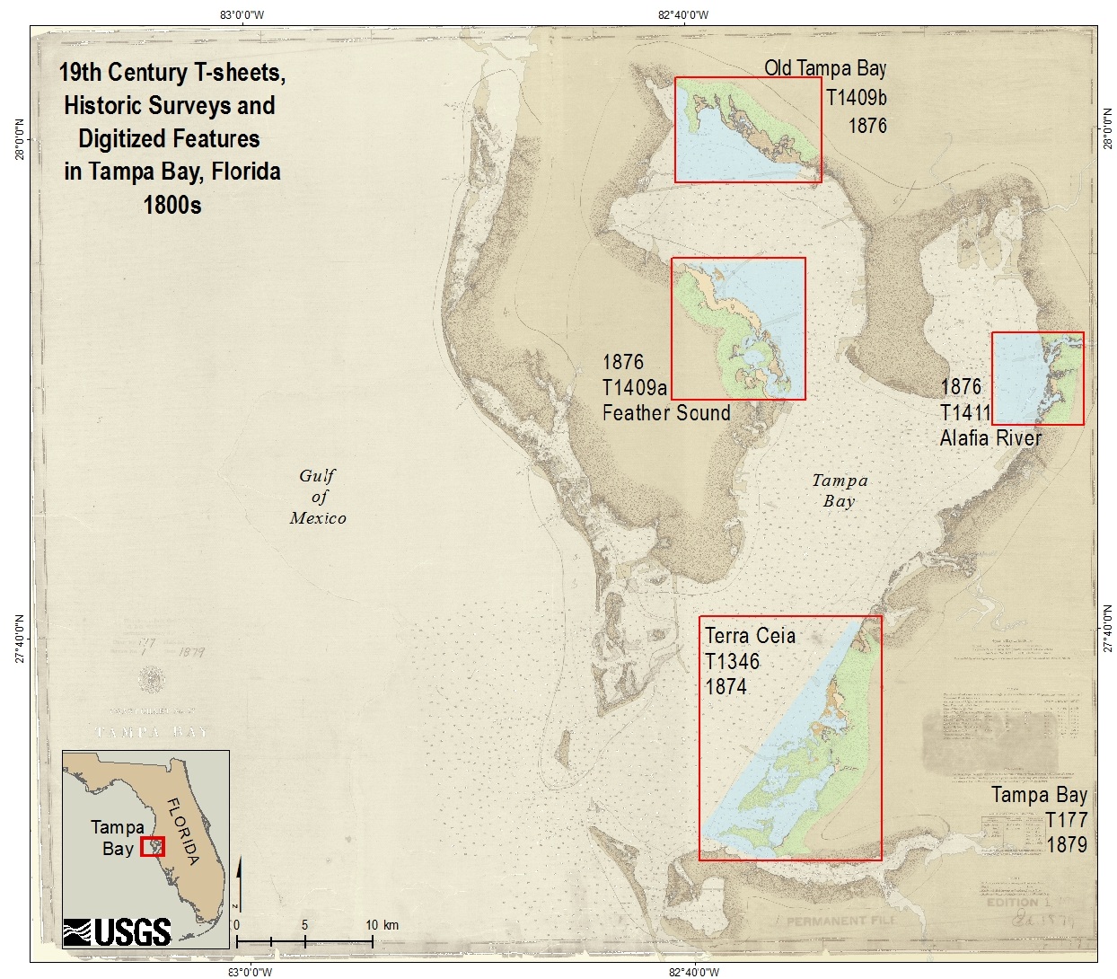
Historic data at four study sites in Tampa Bay, Florida, were prepared from 19th century U.S. Coast and Geodetic Survey (CGS) topographic charts (T-sheets) and Public Land Surveys (PLS). Members of U.S. Geological Survey (USGS) Tampa Bay Wetlands team converted historic surveys to digital geographic formats for Terra Ceia, Alafia River, Feather Sound, and Old Tampa Bay, using previously established methods (Raabe and others, 2004; Raabe and Schwarz, 2007). These data were applied to long-term change assessment (greater than 100 years) by comparing digitized historic coastal features with modern conditions (Raabe and others, 2012).
Four datasets were prepared by the USGS from the historic surveys: (1) four georectified 1:20,000 T-sheet images; (2) vector shapefiles of coastal features digitized from the original T-sheets; (3) vector shapefiles of PLS landscape features and bearing trees surveyed along Township and Range lines (1842-1858); and (4) regional historic maps in digital format. The raster images and vector data document historic coastal conditions in Tampa Bay, depicting the coastal landscape as it appeared in the mid-1800s. Users of the data should be aware that the data reflect survey methods and perspectives from the 19th century. The shoreline and other features may have changed in the intervening years.
Recovery of historic data to a digital setting adresses the need for data integration through time, bridging technical gaps and differences. The goal of this study was to evaluate a marsh-to-mangrove conversion spanning 125 years and the implications for present coastal-resource management (Yates and others, 2011; Raabe and others, 2012). The U.S. Geological Survey in St. Petersburg, Fla., georectified and digitized 1870s T-sheets at four Tampa Bay locations that still supported coastal wetlands in 2000 (table 1). Nineteenth century Public Land Surveys of Township and Range lines were also digitized for each site, as a secondary data source to verify historic landscape features (table 2).
This report is divided into four sections: Acronyms and Abbreviations, Methods, Data, and Federal Geographic Data Committee (FGDC) Metadata. Links at the top and bottom of each page provide access to these sections. This report contains links to the USGS, collaborators, and other available resources if access to the Internet is available while viewing these documents. Geographic Information System (GIS) files, HyperText Markup Language (HTML) files, and images used to produce the Web pages are also included in this report.
To access the information contained on this disc, use a Web browser to open the file index.html.
Our thanks to the reviewers whose efforts improved this data release. Funding for this study was provided by two U.S. Geological Survey programs: the Coastal and Marine Geology Program Tampa Bay Integrated Science Project and the Ecosystems Program. Special thanks to Jordan Sanford and Minami Sakamoto (USGS interns) for help in registering and digitizing the historic surveys.
Raabe, E.A., Roy, L.C., McIvor, C.C., and Gleim, A.D., 2012, Digital recovery of 19th century surveys in Tampa Bay, Florida: Topographic charts and Public Land Surveys: U.S. Geological Survey Data Series 727, 1 CD-ROM.
Raabe, E.A., Roy, L.C., and McIvor, C.C., 2012, Tampa Bay coastal wetlands: Nineteenth to twentieth century tidal marsh-to-mangrove conversion, Estuaries and Coasts, v. 35, no. 5, p. 1145-1162, DOI: 10.1007/s12237-012-9503-1.
Raabe, E.A., and Schwarz, Myra, 2007, Historic conditions of MacDill AFB, Tampa Bay, Florida: Pre-settlement landscape: U.S. Geological Survey Open-File Report 2007-1141, 1 CD-ROM.
Raabe, E.A., Streck, A.E., and Stumpf, R.P., 2004, Historic topographic sheets to satellite imagery: A methodology for evaluating coastal change in Florida's Big Bend tidal marsh: U.S. Geological Survey Open File Report 02-211 (as revised in 2012), available at https://pubs.usgs.gov/of/2002/of02-211.
Yates, K.K., Greening, Holly, and Morrison, Gerold, eds., 2011, Integrating science and resource management in Tampa Bay, Florida: U.S. Geological Survey Circular 1348, available at https://pubs.usgs.gov/circ/1348/.

![]() U.S. Department of the Interior |
U.S. Geological Survey
U.S. Department of the Interior |
U.S. Geological Survey
URL: http://pubsdata.usgs.gov/pubs/ds/727/index.htm
Page Contact Information: GS Pubs Web Contact
Page Last Modified: Monday, 28-Nov-2016 19:05:39 EST
