Data Series 765
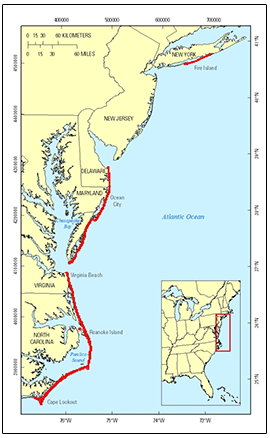
SummaryThis Data Series contains lidar-derived bare-earth (BE) topography, dune elevations, and mean-high-water shoreline position datasets for most sandy beaches for Fire Island, New York, and from Cape Henlopen, Delaware to Cape Lookout, North Carolina. The data were acquired post-Hurricane Sandy, which made landfall as an extratropical cyclone on October 29, 2012. |
First posted May 16, 2013 For additional information contact: Part or all of this report is presented in Portable Document Format (PDF); the latest version of Adobe Reader or similar software is required to view it. Download the latest version of Adobe Reader, free of charge. |
Stockdon, H.F., Doran, K.J., Sopkin, K.L., Smith, K.E.L., and Fredericks, Xan, 2013, Coastal topography–Northeast Atlantic coast, post-hurricane Sandy, 2012: U.S. Geological Survey Data Series 765, https://pubs.usgs.gov/ds/765.
Purpose
Metadata
Collaborators
Acroynyms

![]() U.S. Department of the Interior |
U.S. Geological Survey
U.S. Department of the Interior |
U.S. Geological Survey
URL: http://pubsdata.usgs.gov/pubs/ds/765/index.html
Page Contact Information: GS Pubs Web Contact
Page Last Modified: Monday, 28-Nov-2016 19:12:59 EST

