U.S. Geological Survey Data Series 773
1U.S. Geological Survey, St. Petersburg, FL 33701.
2Florida Geological Survey, Tallahassee, FL 32304.
U.S. Department of the Interior
U.S. Geological Survey
St. Petersburg Coastal and Marine Science Center
Publications are available from USGS Information Services, Box 25286, Federal Center, Denver, CO 80225-0046 (telephone 1-888-ASK-USGS; e-mail: [email protected]).
Page Contents: |
||||
 |
||||
This Digital Versatile Disc (DVD) publication was prepared by an agency of the United States Government. Although these data have been processed successfully on a computer system at the U.S. Geological Survey (USGS), no warranty expressed or implied is made regarding the display or utility of the data on any other system, nor shall the act of distribution imply any such warranty. The USGS shall not be held liable for improper or incorrect use of the data described and (or) contained herein. Reference herein to any specific commercial product, process, or service by trade name, trademark, manufacturer, or otherwise does not constitute or imply its endorsement, recommendation, or favoring by the United States Government or any agency thereof.
This disc is readable on any computing platform that has standard DVD driver software installed. The minimum software requirements are a Web browser, a portable document format (PDF) reader, and a text editor. If you cannot fully access the information on this page, please contact USGS Information Services at [email protected] or 1-888-ASK-USGS.
To access the information contained on this disc, use a Web browser to open the file index.html. This report is divided into seven sections: Acronyms and Abbreviations, Disc Contents, Navigation Data and Maps, Subbottom Profiles, Field Activity Logs, FGDC Metadata, and Software. Links at the top and bottom of each page provide access to these sections. This report contains links to the USGS and collaborators or other resources that are only accessible if access to the Internet is available while viewing these documents.
This disc contains a readme (2-KB text file) document, which provides a brief description of the report; a folder containing Society of Exploration Geophysicists (SEG) SEG Y binary data files; Geographic Information System (GIS) files; and all the Hypertext Markup Language (HTML) files, folders, and images used to produce the Web pages included in this report. The Contents page contains a diagram providing locations and links to all files and folders contained on this disc.
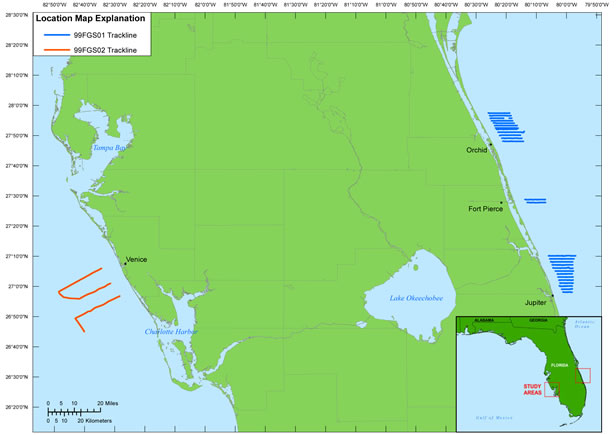
In July (19 - 26) and November (17 - 18) of 1999, the USGS, in cooperation with the Florida Geological Survey (FGS), conducted two geophysical surveys in: (1) the Atlantic Ocean offshore of Florida's east coast from Orchid to Jupiter, FL, and (2) the Gulf of Mexico offshore of Venice, FL (figure 1). This report serves as an archive of unprocessed digital boomer subbottom data, trackline maps, navigation files, GIS files, Field Activity Collection System (FACS) logs, and formal Federal Geographic Data Committee (FGDC) metadata. Filtered and gained (showing a relative increase in signal amplitude) digital images of the subbottom profiles are also provided. Refer to the Acronyms page for explanations of acronyms and abbreviations used in this report.
The USGS St. Petersburg Coastal and Marine Science Center (SPCMSC) assigns a unique identifier to each cruise or field activity. For example, identifiers 99FGS01 and 99FGS02 refer to field data collected in 1999 for cooperative work with the FGS. The numbers 01 and 02 indicate the data were collected during the first and second field activities for that project in that calendar year. Refer to http://walrus.wr.usgs.gov/infobank/programs/html/definition/activity.html for a detailed description of the method used to assign the field activity identification (ID).
The boomer subbottom processing system consists of an acoustic energy source that is made up of capacitors charged to a high voltage and discharged through a transducer in the water. The transducer is towed on a sled floating on the water surface and when discharged emits a short acoustic pulse, or shot, which propagates through the water column and shallow stratigraphy below. The acoustic energy is reflected at density boundaries (such as the seafloor or sediment layers beneath the seafloor), detected by the receiver (a hydrophone streamer), and recorded by a PC-based seismic acquisition system as data traces. This process is repeated at timed intervals (for example, 0.5 s) and recorded for specific intervals of time (for example, 100 ms). In this way, a two-dimensional (2-D) vertical image of the shallow geologic structure beneath the ship track is produced. Figure 2 displays the acquisition geometry. Refer to table 1 for a summary of acquisition parameters, table 2 for 99FGS01 trackline statistics, and table 3 for 99FGS02 trackline statistics.
The archived trace data are in standard SEG Y format (Barry and others, 1975), except an ASCII format is used for the first 3,200 bytes of the card image header instead of the standard EBCDIC format. For a detailed description about the recorded trace headers, refer to the SEG Y Format page. The SEG Y files may be downloaded and processed with commercial or public domain software such as Seismic Unix (SU) (Cohen and Stockwell, 2010). See the How To Download SEG Y Data page for download instructions. The web version of this archive does not contain the SEG Y trace files. These files are very large and would require extremely long download times. To obtain the complete DVD archive, contact USGS Information at 1-888-ASK-USGS or [email protected]. The printable profiles provided here are GIF images that were processed and gained using SU software and can be viewed from the Profiles page or from links located on the trackline map; refer to the Software page for links to example SU processing scripts. The SEG Y files are available on the DVD version of this data series or on the Web, downloadable via the USGS Coastal and Marine Geoscience Data System (http://cmgds.marine.usgs.gov). The data are also available for viewing using GeoMapApp (http://www.geomapapp.org) and Virtual Ocean (http://www.virtualocean.org) multi-platform open source software.
Detailed information about the navigation system used can be found in table 1. To view the trackline maps and navigation files, and for more information about these items, see the Navigation page.
Funding for this study was provided by the USGS Coastal and Marine Geology Program (CMGP) and FGS. This document was improved by the reviews of Ellen Raabe (USGS) and Theresa Burress (Cherokee Nation Technology Solutions) of the USGS - St. Petersburg, FL.
Barry, K.M., Cavers, D.A., and Kneale, C.W., 1975, Recommended standards for digital tape formats: Geophysics, v. 40, no. 2, p. 344-352. Available online at http://www.seg.org/resources/publications/misc/technical-standards.
Cohen, J.K., and Stockwell, J.W., Jr., 2010, CWP/SU: Seismic Unix Release 41: A free package for seismic research and processing: Center for Wave Phenomena, Colorado School of Mines. Available online at http://www.cwp.mines.edu/cwpcodes/.
Zihlman, F.N., 1992, DUMPSEGY V1.0: A program to examine the contents of SEG Y disk-image seismic data: U.S. Geological Survey Open-File Report 92-590, 28 p. Available online at http://pubs.er.usgs.gov/usgspubs/ofr/ofr92590.
Forde, A.S., Dadisman, S.V., Wiese, D.S., and Phelps, D.C., 2013, Archive of Digital boomer subbottom data collected during USGS cruises 99FGS01 and 99FGS02 offshore southeast and s outhwest Florida, July and November, 1999: U.S. Geological Survey Data Series 773, 1 DVD.

![]() U.S. Department of the Interior |
U.S. Geological Survey
U.S. Department of the Interior |
U.S. Geological Survey
URL: http://pubsdata.usgs.gov/pubs/ds/773/title.html
Page Contact Information: GS Pubs Web Contact
Page Last Modified: Monday, 28-Nov-2016 19:15:41 EST
