Bathymetry--Drakes Bay and Vicinity, California

Metadata:

Identification_Information:
Citation:
Citation_Information:
Originator: Peter Dartnell
Originator: Rikk G. Kvitek
Publication_Date: 2014
Title: Bathymetry--Drakes Bay and Vicinity, California
Edition: 1.0
Geospatial_Data_Presentation_Form: GeoTiff
Series_Information:
Series_Name: Data Series
Issue_Identification: DS 781
Publication_Information:
Publication_Place: Reston, VA
Publisher: U.S. Geological Survey
Online_Linkage: https://pubs.usgs.gov/ds/781/
Online_Linkage: Online_Linkage: Larger_Work_Citation:
Citation_Information:
Originator: Nadine E. Golden
Publication_Date: 2013
Title: California State Waters Map Series Data Catalog
Geospatial_Data_Presentation_Form: database
Series_Information:
Series_Name: Data Series
Issue_Identification: DS 781
Publication_Information:
Publication_Place: Reston, VA
Publisher: U.S. Geological Survey
Online_Linkage: https://doi.org/10.3133/ds781
Online_Linkage: https://pubs.usgs.gov/ds/781/
Description:
Abstract:
This part of DS 781 presents data for the bathymetry map of Drakes Bay and Vicinity map area, California. The raster data file for the bathymetry map is included in "Bathymetry_DrakesBay.zip," which is accessible from https://pubs.usgs.gov/ds/781/DrakesBay/data_catalog_DrakesBay.html. These data accompany the pamphlet and map sheets of Watt, J.T., Dartnell, P., Golden, N.E., Greene, H.G., Erdey, M.D., Cochrane, G.R., Johnson, S.Y., Hartwell, S.R., Kvitek, R.G., Manson, M.W., Endris, C.A., Dieter, B.E., Sliter, R.W., Krigsman, L.M., Lowe, E.N., and Chin, J.L. (J.T. Watt and S.A. Cochran, eds.), 2015, California State Waters Map Series—Drakes Bay and Vicinity, California: U.S. Geological Survey Open-File Report 2015–1041, pamphlet 36 p., 10 sheets, scale 1:24,000, https://doi.org/10.3133/ofr20151041.
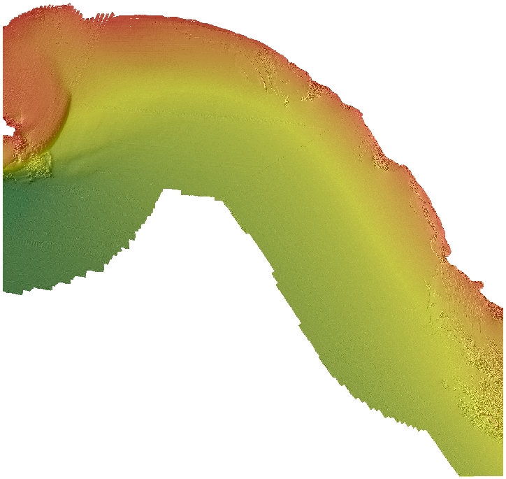
The bathymetry map of Drakes Bay and Vicinity map area, California, was generated from bathymetry data collected by California State University, Monterey Bay (CSUMB), and by Fugro Pelagos. Mapping was completed between 2007 and 2010, using a combination of 200-kHz and 400-kHz Reson 7125, and 244-kHz Reson 8101 multibeam echosounders, as well as 468-kHz SEA SWATHPlus interferometric system. These mapping missions combined to collect bathymetry from about the 10-m isobath to beyond the 3-nautical-mile limit of California's State Waters. NOTE: the horizontal datum of the bathymetry data (NAD83) differs from the horizontal datum of other layers in this data series (WGS84). Some bathymetry grids within this map were projected horizontally from WGS84 to NAD83 using Esri tools to be more consistent with the vertical reference of the North American Vertical Datum of 1988 (NAVD88). These data are not intended for navigational purposes.
Purpose:
These data are intended for science researchers, students, policy makers, and the general public. These data can be used with geographic information systems or other software to identify bathymetric features.
Supplemental_Information:
Any use of trade, product, or firm names is for descriptive purposes only and does not imply endorsement by the U.S. Government.
Although this Federal Geographic Data Committee-compliant metadata file is intended to document the data set in nonproprietary form, as well as in Esri format, this metadata file may include some Esri-specific terminology.
Time_Period_of_Content:
Time_Period_Information:
Range_of_Dates/Times:
Beginning_Date: 2007
Ending_Date: 2010
Currentness_Reference: ground condition
Status:
Progress: Complete
Maintenance_and_Update_Frequency: As needed
Spatial_Domain:
Bounding_Coordinates:
West_Bounding_Coordinate: -122.97
East_Bounding_Coordinate: -122.76
North_Bounding_Coordinate: 38.03
South_Bounding_Coordinate: 37.88
Keywords:
Theme:
Theme_Keyword_Thesaurus: USGS Metadata Identifier
Theme_Keyword: USGS:3dd26fd3-6bdd-4e16-8473-4672601ada58
Theme:
Theme_Keyword_Thesaurus: Global Change Master Directory (GCMD)
Theme_Keyword: Bathymetry
Theme_Keyword: Seafloor Topography
Theme:
Theme_Keyword_Thesaurus: ISO 19115 Topic Category
Theme_Keyword: geoscientificInformation
Theme_Keyword: environment
Theme_Keyword: oceans
Theme_Keyword: imageryBaseMapsEarthCover
Theme:
Theme_Keyword_Thesaurus: Data Categories for Marine Planning
Theme_Keyword: distributions
Theme_Keyword: bathymetry and elevation
Theme:
Theme_Keyword_Thesaurus: Marine Realms Information Bank (MRIB) keywords
Theme_Keyword: multibeam echo sounder
Theme_Keyword: seabed
Theme:
Theme_Keyword_Thesaurus: USGS Thesaurus
Theme_Keyword: sonar methods
Theme_Keyword: interferometric sonar
Theme_Keyword: bathymetry measurement
Theme_Keyword: bathymetry
Theme_Keyword: marine geophysics
Theme_Keyword: maps and atlases
Theme_Keyword: geospatial datasets
Theme:
Theme_Keyword_Thesaurus: Coastal and Marine Ecological Classification Standard (CMECS)
Theme_Keyword: Marine Nearshore Subtidal
Theme_Keyword: Marine Offshore Subtidal
Theme_Keyword: Transform Continental Margin
Theme_Keyword: Continental/Island Shelf
Theme_Keyword: Rock Substrate
Theme_Keyword: Unconsolidated Mineral Substrate
Place:
Place_Keyword_Thesaurus: Geographic Names Information System (GNIS)
Place_Keyword: Pacific Ocean
Place_Keyword: State of California
Place_Keyword: Drakes Bay
Place_Keyword: Marin County
Place:
Place_Keyword_Thesaurus: Coastal and Marine Ecological Classification Standard (CMECS)
Place_Keyword: Northern California Ecoregion
Stratum:
Stratum_Keyword_Thesaurus: Coastal and Marine Ecological Classification Standard (CMECS)
Stratum_Keyword: Substrate
Access_Constraints: none
Use_Constraints:
USGS-authored or produced data and information are in the public domain from the U.S. Government and are freely redistributable with proper metadata and source attribution. Please recognize and acknowledge the U.S. Geological Survey as the originator(s) of the dataset and in products derived from these data. This information is not intended for navigation purposes.
Point_of_Contact:
Contact_Information:
Contact_Organization_Primary:
Contact_Organization:
U.S. Geological Survey, Pacific Coastal and Marine Science Center
Contact_Person: PCMSC Science Data Coordinator
Contact_Address:
Address_Type: mailing and physical
Address: 2885 Mission Street
City: Santa Cruz
State_or_Province: CA
Postal_Code: 95060-5792
Country: US
Contact_Voice_Telephone: 831-427-4747
Contact_Electronic_Mail_Address: pcmsc_data@usgs.gov
Browse_Graphic:
Browse_Graphic_File_Name: Browse_Graphic_File_Description: Bathymetry map of Drakes Bay and Vicinity.
Browse_Graphic_File_Type: JPEG
Native_Data_Set_Environment:
Microsoft Windows Server 2008 R2 Version 6.1 (Build 7601) Service Pack 1; ESRI ArcCatalog 10.0
Cross_Reference:
Citation_Information:
Originator: Janet T. Watt
Originator: Peter Dartnell
Originator: Nadine E. Golden
Originator: H. Gary Greene
Originator: Mercedes E. Erdey
Originator: Guy R. Cochrane
Originator: Samuel Y. Johnson
Originator: Stephen R. Hartwell
Originator: Rikk G. Kvitek
Originator: Michael W. Manson
Originator: Charles A. Endris
Originator: Bryan E. Dieter
Originator: Ray W. Sliter
Originator: Lisa M. Krigsman
Originator: Erik N. Lowe
Originator: John L. Chin
Publication_Date: 2018
Title:
California State Waters Map Series--Drakes Bay and Vicinity, California
Geospatial_Data_Presentation_Form: pamphlet and map sheets
Series_Information:
Series_Name: Open-File Report
Issue_Identification: 2015-1041
Publication_Information:
Publication_Place: Reston, VA
Publisher: U.S. Geological Survey
Online_Linkage: https://doi.org/10.3133/ofr20151041
Data_Quality_Information:
Attribute_Accuracy:
Attribute_Accuracy_Report: Not applicable for raster data.
Logical_Consistency_Report: Unspecified
Completeness_Report: Complete
Positional_Accuracy:
Horizontal_Positional_Accuracy:
Horizontal_Positional_Accuracy_Report:
Horizontal_Positional_Accuracy_Report: Estimated to be no less than 2 m, owing to water depth and total propagated uncertainties of the mapping systems, which include sonar system, position and motion compensation system, and navigation, as well as data processing that includes sounding cleaning, gridding, and datum transformations.
Vertical_Positional_Accuracy:
Vertical_Positional_Accuracy_Report:
Vertical_Positional_Accuracy_Report: Estimated to be no less than 20 cm, owing to water depth and total propagated uncertainties of the mapping systems, which include sonar system, position and motion compensation system, and navigation, as well as data processing that includes sounding cleaning, gridding, and datum transformations.
Lineage:
Process_Step:
Process_Description:
During the Fugro Pelagos and CSUMB mapping missions, an Applanix Position and Motion Compensation System for Marine Vessels (POS/MV, 320, v4) was used to accurately position the vessels during data collection, and it also accounted for vessels motion such as heave, pitch, and roll (position accuracy, ±2 m; pitch, roll, and heading accuracy, ±0.02 degrees; heave accuracy, ±5%, or 5 cm). KGPS altitude data (Fugro Pelagos, StarFix HP and XP units; CSUMB, NavCom 2050) were used to account for tide cycle fluctuations and sound velocity profiles were collected with an Applied Microsystems SVPlus sound velocimeter. Soundings were corrected for vessel motion using the Applanix POS/MV data, for variations in water-column sound velocity using the AM SVPlus data, and for variations in water height (tides) using vertical-position data from the KGPS receivers.
Process_Date: 2010
Process_Contact:
Contact_Information:
Contact_Person_Primary:
Contact_Person: Carrie K. Bretz
Contact_Organization: Seafloor Mapping Lab, California State Univ. Monterey Bay
Contact_Position: Projects manager, GIS and metadata supervisor
Contact_Address:
Address_Type: mailing and physical address
Address: 100 Campus Center, Bldg 13
City: Seaside
State_or_Province: CA
Postal_Code: 93955
Country: USA
Contact_Voice_Telephone: (831) 582-4197
Contact_Electronic_Mail_Address: cbretz@csumb.edu
Process_Step:
Process_Description:
California Seafloor Mapping Project 2-m-resolution bathymetry data within this map area were downloaded from http://seafloor.csumb.edu/SFMLwebDATA.htm.
Process_Date: 2012
Process_Step:
Process_Description:
Merge all bathymetry data into 2-m-resolution bathymetry grid and clip to the Drakes Bay and Vicinity, California, map boundary.
Process_Date: 2012
Process_Step:
Process_Description:
Added Distribution_Information section to metadata to facilitate data download.
Process_Date: 20171005
Process_Contact:
Contact_Information:
Contact_Organization_Primary:
Contact_Organization: U.S. Geological Survey
Contact_Person: Alan O. Allwardt
Contact_Position: Contractor -- Information Specialist
Contact_Address:
Address_Type: mailing and physical address
Address: 2885 Mission Street
City: Santa Cruz
State_or_Province: CA
Postal_Code: 95060
Contact_Voice_Telephone: 831-460-7551
Contact_Facsimile_Telephone: 831-427-4748
Contact_Electronic_Mail_Address: aallwardt@usgs.gov
Process_Step:
Process_Description:
Keywords section of metadata optimized for discovery in USGS Coastal and Marine Geology Data Catalog.
Process_Date: 20171005
Process_Contact:
Contact_Information:
Contact_Organization_Primary:
Contact_Organization: U.S. Geological Survey
Contact_Person: Alan O. Allwardt
Contact_Position: Contractor -- Information Specialist
Contact_Address:
Address_Type: mailing and physical address
Address: 2885 Mission Street
City: Santa Cruz
State_or_Province: CA
Postal_Code: 95060
Contact_Voice_Telephone: 831-460-7551
Contact_Facsimile_Telephone: 831-427-4748
Contact_Electronic_Mail_Address: aallwardt@usgs.gov
Process_Step:
Process_Description:
Added keywords from Coastal and Marine Ecological Classification Standard (CMECS) to metadata.
Process_Date: 20180426
Process_Contact:
Contact_Information:
Contact_Organization_Primary:
Contact_Organization: U.S. Geological Survey
Contact_Person: Alan O. Allwardt
Contact_Position: Contractor -- Information Specialist
Contact_Address:
Address_Type: mailing and physical address
Address: 2885 Mission Street
City: Santa Cruz
State_or_Province: CA
Postal_Code: 95060
Contact_Voice_Telephone: 831-460-7551
Contact_Facsimile_Telephone: 831-427-4748
Contact_Electronic_Mail_Address: aallwardt@usgs.gov
Process_Step:
Process_Description:
Metadata was modified to bring up to current USGS PCMSC standards. USGS Thesaurus and keywords were added, and Process Steps were refined. Minor typos were corrected. No data information was changed.
Process_Date: 20180510
Process_Contact:
Contact_Information:
Contact_Person_Primary:
Contact_Person: Susan A Cochran
Contact_Organization:
U.S. Geological Survey, Pacific Coastal and Marine Science Center
Contact_Position: Geologist
Contact_Address:
Address_Type: mailing and physical address
Address: 2885 Mission Street
City: Santa Cruz
State_or_Province: CA
Postal_Code: 95060-5792
Country: USA
Contact_Voice_Telephone: (831) 460-7545
Contact_Electronic_Mail_Address: scochran@usgs.gov
Process_Step:
Process_Description:
Information for accompanying Open-File Report added to Abstract and Cross Reference sections. Point of Contact information was updated. Details about different Network Resource Name links was given in the Access Instructions section. Phone number for Metadata Contact was corrected. No data information was changed.
Process_Date: 20180907
Process_Contact:
Contact_Information:
Contact_Person_Primary:
Contact_Person: Susan A Cochran
Contact_Organization:
U.S. Geological Survey, Pacific Coastal and Marine Science Center
Contact_Address:
Address_Type: mailing and physical
Address: 2885 Mission St.
City: Santa Cruz
State_or_Province: CA
Postal_Code: 95060
Country: United States
Contact_Voice_Telephone: 831-460-7545
Contact_Electronic_Mail_Address: scochran@usgs.gov
Process_Step:
Process_Description:
Edited metadata to add keywords section with USGS persistent identifier as theme keyword. No data were changed.
Process_Date: 20201019
Process_Contact:
Contact_Information:
Contact_Organization_Primary:
Contact_Organization: U.S. Geological Survey
Contact_Person: VeeAnn A. Cross
Contact_Position: Marine Geologist
Contact_Address:
Address_Type: Mailing and Physical
Address: 384 Woods Hole Road
City: Woods Hole
State_or_Province: MA
Postal_Code: 02543-1598
Contact_Voice_Telephone: 508-548-8700 x2251
Contact_Facsimile_Telephone: 508-457-2310
Contact_Electronic_Mail_Address: vatnipp@usgs.gov
Process_Step:
Process_Description:
Edited metadata to correct onlink tag information. No data were changed. The metadata available from a harvester may supersede metadata bundled within a download file. Users are advised to compare the metadata date of this file to any similar file to ensure they are using the most recent version.
Process_Date: 20220215
Process_Contact:
Contact_Information:
Contact_Person_Primary:
Contact_Person: Susan A Cochran
Contact_Organization:
U.S. Geological Survey, Pacific Coastal and Marine Science Center
Contact_Address:
Address_Type: mailing and physical
Address: 2885 Mission St.
City: Santa Cruz
State_or_Province: CA
Postal_Code: 95060
Country: United States
Contact_Voice_Telephone: 831-460-7545
Contact_Electronic_Mail_Address: scochran@usgs.gov
Spatial_Data_Organization_Information:
Direct_Spatial_Reference_Method: Raster
Raster_Object_Information:
Raster_Object_Type: Grid Cell
Row_Count: 8392
Column_Count: 8871
Vertical_Count: 1
Spatial_Reference_Information:
Horizontal_Coordinate_System_Definition:
Planar:
Grid_Coordinate_System:
Grid_Coordinate_System_Name: Universal Transverse Mercator
Universal_Transverse_Mercator:
UTM_Zone_Number: 10
Transverse_Mercator:
Scale_Factor_at_Central_Meridian: 0.9996
Longitude_of_Central_Meridian: -123.00000
Latitude_of_Projection_Origin: 0.00000
False_Easting: 500000.0
False_Northing: 0.00
Planar_Coordinate_Information:
Planar_Coordinate_Encoding_Method: coordinate pair
Coordinate_Representation:
Abscissa_Resolution: 2.0
Ordinate_Resolution: 2.0
Planar_Distance_Units: Meters
Geodetic_Model:
Horizontal_Datum_Name: NAD83
Ellipsoid_Name: GRS80
Semi-major_Axis: 6378137.00
Denominator_of_Flattening_Ratio: 298.257223563
Entity_and_Attribute_Information:
Overview_Description:
Entity_and_Attribute_Overview:
The complete Drakes Bay and Vicinity bathymetry data was originally archived as an Esri grid with the following attributes:
Cell size = 2.0
Number of rows = 8392
Number of columns = 8871

Data type = floating point

Boundary
Xmin = 502947
Xmax = 520689
Ymin = 4192361
Ymax = 4209145

Statistics
Minimum value = -62.3
Maximum value = -0.07
Mean = -33.8
Standard deviation = 13.5

Coordinate system description
Projection  UTM
Zone  10
Datum  NAD83
Vertical Datum  NAVD88
Units  meter
Entity_and_Attribute_Detail_Citation: none
Distribution_Information:
Distributor:
Contact_Information:
Contact_Organization_Primary:
Contact_Organization: U.S. Geological Survey
Contact_Address:
Address_Type: mailing and physical address
Address: 345 Middlefield Rd
City: Menlo Park
State_or_Province: CA
Postal_Code: 94025-3561
Country: USA
Contact_Voice_Telephone: (650) 329-4309
Resource_Description:
The .zip file (https://pubs.usgs.gov/ds/781/DrakesBay/data/Bathymetry_DrakesBay.zip) includes the .tfw, .tif, .tif.aux.xml, and .tif.ovr files, as well as FGDC-compliant metadata for the Bathymetry data layer in the Drakes Bay and Vicinity region of California.
Distribution_Liability:
Unless otherwise stated, all data, metadata and related materials are considered to satisfy the quality standards relative to the purpose for which the data were collected. Although these data and associated metadata have been reviewed for accuracy and completeness and approved for release by the U.S. Geological Survey (USGS), no warranty expressed or implied is made regarding the display or utility of the data on any other system or for general or scientific purposes, nor shall the act of distribution constitute any such warranty.
Standard_Order_Process:
Digital_Form:
Digital_Transfer_Information:
Format_Name: GeoTiff
Format_Version_Number: ArcMap (version 10.0, ESRI, 2011)
Format_Specification:
Raster data layer is registered TIFF image in the UTM Zone 10 coordinate system.
Format_Information_Content:
The .zip file for the TIFF image includes the image (.tif), the world registration file (.tfw), and FGDC-compliant metadata.
File_Decompression_Technique: WinZip
Transfer_Size: 35.3
Digital_Transfer_Option:
Online_Option:
Computer_Contact_Information: Access_Instructions:
The first link will begin a direct download of the data. The second link is a landing page on which all of the downloadable data for a particular region are listed. The third link is a landing page for the entire data catalog.
Fees: none
Technical_Prerequisites:
The downloadable data file has been compressed with the "zip" command and can be unzipped with Winzip (or other tool) on Windows systems. To utilize these data, the user must have software capable of uncompressing the WinZip file and importing and viewing an Esri ArcMap TIFF. Users should download the ArcGIS Project File, DrakesBayGIS.mxd.zip, a compressed (with the "zip" command) version of the ArcMap document (.mxd) that has all the data layers loaded in the table of contents for “Drakes Bay and Vicinity“ and has all the data symbolized as on the map sheets. Download and save this ArcGIS project file, including all data layers, to the directory the user has created for this GIS.
Metadata_Reference_Information:
Metadata_Date: 20220215
Metadata_Contact:
Contact_Information:
Contact_Organization_Primary:
Contact_Organization:
U.S. Geological Survey, Pacific Coastal and Marine Science Center
Contact_Person: PCMSC Science Data Coordinator
Contact_Address:
Address_Type: mailing and physical
Address: 2885 Mission Street
City: Santa Cruz
State_or_Province: CA
Postal_Code: 95060-5792
Country: US
Contact_Voice_Telephone: 831-427-4747
Contact_Electronic_Mail_Address: pcmsc_data@usgs.gov
Metadata_Standard_Name: Content Standard for Digital Geospatial Metadata
Metadata_Standard_Version: FGDC-STD-001-1998
Metadata_Time_Convention: local time

Generated by mp version 2.9.51 on Tue Feb 15 09:14:03 2022