Seafloor character--Drakes Bay and Vicinity, California

Metadata:

Identification_Information:
Citation:
Citation_Information:
Originator: Mercedes D. Erdey
Originator: Guy R. Cochrane
Publication_Date: 2014
Title: Seafloor character--Drakes Bay and Vicinity, California
Geospatial_Data_Presentation_Form: GeoTiff
Series_Information:
Series_Name: Data Series
Issue_Identification: DS 781
Publication_Information:
Publication_Place: Reston, VA
Publisher: U.S. Geological Survey
Online_Linkage: https://pubs.usgs.gov/ds/781/
Online_Linkage: Online_Linkage: Larger_Work_Citation:
Citation_Information:
Originator: Nadine E. Golden
Publication_Date: 2013
Title: California State Waters Map Series Data Catalog
Geospatial_Data_Presentation_Form: database
Series_Information:
Series_Name: Data Series
Issue_Identification: DS 781
Publication_Information:
Publication_Place: Reston, VA
Publisher: U.S. Geological Survey
Online_Linkage: https://doi.org/10.3133/ds781
Online_Linkage:
Description:
Abstract:
This part of DS 781 presents the seafloor-character map of the Drakes Bay and Vicinity map area, California (raster data file is included in "SeafloorCharacter_DrakesBay.zip," which is accessible from https://pubs.usgs.gov/ds/781/DrakesBay/data_catalog_DrakesBay.html). These data accompany the pamphlet and map sheets of Watt, J.T., Dartnell, P., Golden, N.E., Greene, H.G., Erdey, M.D., Cochrane, G.R., Johnson, S.Y., Hartwell, S.R., Kvitek, R.G., Manson, M.W., Endris, C.A., Dieter, B.E., Sliter, R.W., Krigsman, L.M., Lowe, E.N., and Chin, J.L. (J.T. Watt and S.A. Cochran, eds.), 2015, California State Waters Map Series—Drakes Bay and Vicinity, California: U.S. Geological Survey Open-File Report 2015–1041, pamphlet 36 p., 10 sheets, scale 1:24,000, https://doi.org/10.3133/ofr20151041.
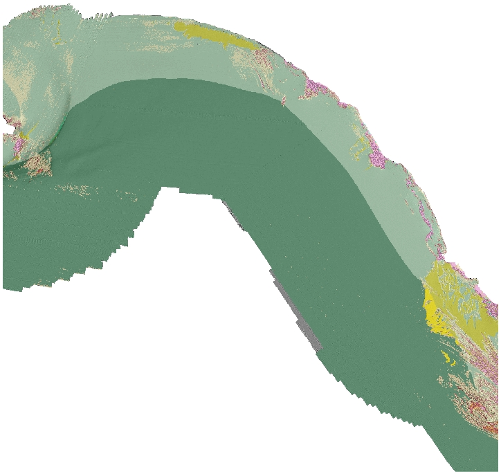
This raster-format seafloor-character map shows four substrate classes of Drakes Bay and Vicinity, California. The substrate classes mapped in this area have been further divided into the following California Marine Life Protection Act depth zones and slope classes: Depth Zone 2 (intertidal to 30 m), Depth Zone 3 (30 to 100 m), Slope Class 1 (0 degrees - 5 degrees), and Slope Class 2 (5 degrees - 30 degrees). Depth Zone 1 (intertidal), Depth Zone 4 (100 to 200 m), Depth Zone 5 (greater than 200 m), and Slope Classes 3-4 (greater than 30 degrees) are not present in the region covered by this block. The map is created using a supervised classification method described by Cochrane (2008).
References Cited:
California Department of Fish and Game, 2008, California Marine Life Protection Act master plan for marine protected areas; Revised draft: California Department of Fish and Game, accessed April 5 2011, at http://www.dfg.ca.gov/mlpa/masterplan.asp.
Cochrane, G.R., 2008, Video-supervised classification of sonar data for mapping seafloor habitat, in Reynolds, J.R., and Greene, H.G., eds., Marine habitat mapping technology for Alaska: Fairbanks, University of Alaska, Alaska Sea Grant College Program, p. 185-194, accessed April 5, 2011, at http://doc.nprb.org/web/research/research%20pubs/615_habitat_mapping_workshop/Individual%20Chapters%20High-Res/Ch13%20Cochrane.pdf.
Sappington, J.M., Longshore, K.M., and Thompson, D.B., 2007, Quantifying landscape ruggedness for animal habitat analysis--A case study using bighorn sheep in the Mojave Desert: Journal of Wildlife Management, v. 71, p. 1419-1426.
Purpose:
These data are intended for science researchers, students, policy makers, and the general public. These data can be used with geographic information systems or other software to identify local seafloor character.
Supplemental_Information:
Any use of trade, product, or firm names is for descriptive purposes only and does not imply endorsement by the U.S. Government.
Although this Federal Geographic Data Committee-compliant metadata file is intended to document the data set in nonproprietary form, as well as in Esri format, this metadata file may include some Esri-specific terminology.
Time_Period_of_Content:
Time_Period_Information:
Range_of_Dates/Times:
Beginning_Date: 2007
Ending_Date: 2010
Currentness_Reference: ground condition
Status:
Progress: Complete
Maintenance_and_Update_Frequency: As needed
Spatial_Domain:
Bounding_Coordinates:
West_Bounding_Coordinate: -122.97
East_Bounding_Coordinate: -122.76
North_Bounding_Coordinate: 38.03
South_Bounding_Coordinate: 37.88
Keywords:
Theme:
Theme_Keyword_Thesaurus: USGS Metadata Identifier
Theme_Keyword: USGS:cdd4d959-1149-4b5b-ad8b-cdb130a95d6c
Theme:
Theme_Keyword_Thesaurus: Global Change Master Directory (GCMD)
Theme_Keyword: Bathymetry
Theme_Keyword: Seafloor Topography
Theme_Keyword: Acoustic Reflectivity
Theme:
Theme_Keyword_Thesaurus: ISO 19115 Topic Category
Theme_Keyword: geoscientificInformation
Theme_Keyword: environment
Theme_Keyword: oceans
Theme_Keyword: imageryBaseMapsEarthCover
Theme:
Theme_Keyword_Thesaurus: Marine Realms Information Bank (MRIB) keywords
Theme_Keyword: seabed
Theme_Keyword: multibeam echo sounder
Theme_Keyword: video observation
Theme_Keyword: photographic sampling
Theme:
Theme_Keyword_Thesaurus: Data Categories for Marine Planning
Theme_Keyword: distributions
Theme_Keyword: substrate
Theme_Keyword: bathymetry and elevation
Theme_Keyword: physical habitats and geomorphology
Theme:
Theme_Keyword_Thesaurus: USGS Thesaurus
Theme_Keyword: sonar methods
Theme_Keyword: image mosaics
Theme_Keyword: interferometric sonar
Theme_Keyword: marine geophysics
Theme_Keyword: sea-floor characteristics
Theme_Keyword: sea-floor acoustic reflectivity
Theme_Keyword: bathymetry measurement
Theme_Keyword: bathymetry
Theme_Keyword: videos
Theme_Keyword: underwater photography
Theme_Keyword: ecosystems
Theme_Keyword: maps and atlases
Theme_Keyword: geospatial datasets
Theme:
Theme_Keyword_Thesaurus: Coastal and Marine Ecological Classification Standard (CMECS)
Theme_Keyword: Marine Nearshore Subtidal
Theme_Keyword: Marine Offshore Subtidal
Theme_Keyword: Transform Continental Margin
Theme_Keyword: Continental/Island Shelf
Theme_Keyword: Rock Substrate
Theme_Keyword: Unconsolidated Mineral Substrate
Place:
Place_Keyword_Thesaurus: Geographic Names Information System (GNIS)
Place_Keyword: Pacific Ocean
Place_Keyword: State of California
Place_Keyword: Northern California
Place_Keyword: Drakes Bay
Place:
Place_Keyword_Thesaurus: Coastal and Marine Ecological Classification Standard (CMECS)
Place_Keyword: Northern California Ecoregion
Stratum:
Stratum_Keyword_Thesaurus: Coastal and Marine Ecological Classification Standard (CMECS)
Stratum_Keyword: Substrate
Access_Constraints: none
Use_Constraints:
USGS-authored or produced data and information are in the public domain from the U.S. Government and are freely redistributable with proper metadata and source attribution. Please recognize and acknowledge the U.S. Geological Survey as the originator(s) of the dataset and in products derived from these data. This information is not intended for navigation purposes.
Point_of_Contact:
Contact_Information:
Contact_Organization_Primary:
Contact_Organization:
U.S. Geological Survey, Pacific Coastal and Marine Science Center
Contact_Person: PCMSC Science Data Coordinator
Contact_Address:
Address_Type: mailing and physical
Address: 2885 Mission Street
City: Santa Cruz
State_or_Province: CA
Postal_Code: 95060-5792
Country: US
Contact_Voice_Telephone: 831-427-4747
Contact_Electronic_Mail_Address: pcmsc_data@usgs.gov
Browse_Graphic:
Browse_Graphic_File_Name: Browse_Graphic_File_Description: Seafloor character of Drakes Bay and Vicinity map area
Browse_Graphic_File_Type: JPEG
Cross_Reference:
Citation_Information:
Originator: Janet T. Watt
Originator: Peter Dartnell
Originator: Nadine E. Golden
Originator: H. Gary Greene
Originator: Mercedes E. Erdey
Originator: Guy R. Cochrane
Originator: Samuel Y. Johnson
Originator: Stephen R. Hartwell
Originator: Rikk G. Kvitek
Originator: Michael W. Manson
Originator: Charles A. Endris
Originator: Bryan E. Dieter
Originator: Ray W. Sliter
Originator: Lisa M. Krigsman
Originator: Erik N. Lowe
Originator: John L. Chin
Publication_Date: 2018
Title:
California State Waters Map Series--Drakes Bay and Vicinity, California
Geospatial_Data_Presentation_Form: pamphlet and map sheets
Series_Information:
Series_Name: Open-File Report
Issue_Identification: 2015-1041
Publication_Information:
Publication_Place: Reston, VA
Publisher: U.S. Geological Survey
Online_Linkage: https://doi.org/10.3133/ofr20151041
Data_Quality_Information:
Attribute_Accuracy:
Attribute_Accuracy_Report: Pixel resolution is 2 m
Logical_Consistency_Report:
Classification was done on the basis of training samples delineated by interpreter. The classification was performed using mathematical algorithms then hand-edited by the interpreter to remove noise.
Completeness_Report:
Total coverage for the survey area is 100%. Survey area is defined by coverage of both the multibeam bathymetry and backscatter datasets.
Positional_Accuracy:
Horizontal_Positional_Accuracy:
Horizontal_Positional_Accuracy_Report:
Positional information reflects the position of the camera and was collected using a still photo camera, WAAS-enabled GSP unit, recording at between 1 to 2 nm. DGPS (WAAS) accuracy for position is less than 3 meters. (From Garmin GPSMAP 76C/76CS Specifications, M01-10108-00, Rev0304, <https://http://www8.garmin.com/specs/GPSMAP76C_76CSspec.pdf>).
Lineage:
Source_Information:
Source_Citation:
Citation_Information:
Originator: Peter Dartnell
Originator: Rikk G. Kvitek
Originator: Carrie K. Bretz
Publication_Date: 2013
Title: Bathymetry--Drakes Bay and Vicinity, California
Geospatial_Data_Presentation_Form: raster digital data
Series_Information:
Series_Name: Data Series
Issue_Identification: DS 781
Publication_Information:
Publication_Place: Reston, VA
Publisher: U.S. Geological Survey
Other_Citation_Details:
See metadata for bathymetry ("Bathymetry_DrakesBay_metadata.txt") in DS 781 for source data and postprocessing/reprocessing information.
Online_Linkage:
Type_of_Source_Media: digital file of gridded bathymetry data (ArcInfo GRID)
Source_Time_Period_of_Content:
Time_Period_Information:
Range_of_Dates/Times:
Beginning_Date: 2006
Ending_Date: 2009
Source_Currentness_Reference: ground condition
Source_Citation_Abbreviation: bathymetry
Source_Contribution: Gridded bathymetry data (2-meter resolution)
Source_Information:
Source_Citation:
Citation_Information:
Originator: Peter Dartnell
Originator: Rikk G. Kvitek
Publication_Date: 2013
Title: Backscatter--Drakes Bay and Vicinity, California
Geospatial_Data_Presentation_Form: raster digital data
Series_Information:
Series_Name: Data Series
Issue_Identification: DS 781
Publication_Information:
Publication_Place: Reston, VA
Publisher: U.S. Geological Survey
Other_Citation_Details:
See metadata for backscatter datasets ("BackscatterA_8101_DrakesBay_metadata.txt", "BackscatterB_Swath_DrakesBay_metadata.txt" and "BackscatterC_7125_DrakesBay_metadata.txt") in DS 781 for amplitude source data and postprocessing/reprocessing information.
Online_Linkage: Online_Linkage: Online_Linkage:
Type_of_Source_Media: digital file of gridded amplitude data (ArcInfo GRID)
Source_Time_Period_of_Content:
Time_Period_Information:
Range_of_Dates/Times:
Beginning_Date: 2006
Ending_Date: 2007
Source_Currentness_Reference: ground condition
Source_Citation_Abbreviation: backscatter
Source_Contribution: Gridded backscatter amplitude data (2-meter resolution)
Source_Information:
Source_Citation:
Citation_Information:
Originator: Brian Edwards
Originator: Eleyne Phillips
Originator: Nadine Golden
Originator: Lisa Krigsman
Originator: Pete Dartnell
Publication_Date: 2012
Title: F307NC_video_observations
Edition: Version 1.0, 2012
Series_Information:
Series_Name: Data Series
Issue_Identification: DS 781
Publication_Information:
Publication_Place: Reston, VA
Publisher: U.S. Geological Survey
Other_Citation_Details:
See metadata for F307NC video observations ("f307nc_video_observations_metadata.txt") in DS 781 for source data and postprocessing/reprocessing information.
Online_Linkage:
Type_of_Source_Media: vector digital data
Source_Time_Period_of_Content:
Time_Period_Information:
Range_of_Dates/Times:
Beginning_Date: 20070927
Ending_Date: 20071011
Source_Currentness_Reference: ground condition
Source_Citation_Abbreviation: imagery
Source_Contribution:
seafloor interpretations from underwater video and sediment samples
Process_Step:
Process_Description:
The seafloor-character map was produced using video-supervised maximum likelihood classification of the bathymetry and intensity of return from sonar systems. The classification was supervised using signatures defined by hand-drawn polygons located through sediment samples and video-observation ground truth data by applying methodology described in Cochrane (2008). The two variants used in this classification were backscatter intensity and derivative rugosity. Rugosity measures terrain ruggedness as the variation in three-dimensional orientation of grid cells within a neighborhood. Vector analysis is used to calculate the dispersion of vectors normal (orthogonal) to grid cells within the specified neighborhood. This method effectively captures variability in slope and aspect into a single measure. Ruggedness values in the output raster map can range from 0 (no terrain variation) to 1 (complete terrain variation). The calculation was performed using the Terrain Ruggedness (VRM) tool (for details, see Sappington and others, 2007).
Classes I, II and III values were delineated using multivariate analysis. Class IV (mobile sedimentary features) values were determined on the basis of visual characteristics using both bathymetry and backscatter (slight depression in the seafloor, very high backscatter return). The resulting map (gridded at 2 m) was cleaned by hand to remove data-collection artifacts (for example trackline nadir). Editing was performed in Photoshop, where individual pixels were selected and values adjusted to remove noise. Selection occurred without antialiasing, and the resulting grid was identical but for the edited pixels. The four seafloor classes were then colored to indicate which of the five California MLPA depth zones they are located in: Depth Zone 2 (intertidal to 30 m), Depth Zone 3 (30 to 100 m), Depth Zone 4 (100 to 200 m), or Depth Zone 5 (greater than 200 m). These were further subdivided into one of the following slope classes: Slope Class 1 (0 degrees - 5 degrees), Slope Class 2 (5 degrees - 30 degrees), Slope Class 3 (30 degrees - 60 degrees), or Slope Class 4 (60 degrees - 90 degrees). Depth Zone 1 (intertidal), Depth Zone 4-5 (greater than 100 m), and Slope Classes 3-4 (greater than 30 degrees) are not present in the Drakes Bay and Viciniy region.
Source_Used_Citation_Abbreviation: bathymetry
Source_Used_Citation_Abbreviation: backscatter
Source_Used_Citation_Abbreviation: imagery
Process_Date: 201302
Process_Step:
Process_Description:
Added Distribution_Information section to metadata to facilitate data download.
Process_Date: 20171005
Process_Contact:
Contact_Information:
Contact_Organization_Primary:
Contact_Organization: U.S. Geological Survey
Contact_Person: Alan O. Allwardt
Contact_Position: Contractor -- Information Specialist
Contact_Address:
Address_Type: mailing and physical address
Address: 2885 Mission Street
City: Santa Cruz
State_or_Province: CA
Postal_Code: 95060
Contact_Voice_Telephone: 831-460-7551
Contact_Facsimile_Telephone: 831-427-4748
Contact_Electronic_Mail_Address: aallwardt@usgs.gov
Process_Step:
Process_Description:
Keywords section of metadata optimized for discovery in USGS Coastal and Marine Geology Data Catalog.
Process_Date: 20171005
Process_Contact:
Contact_Information:
Contact_Organization_Primary:
Contact_Organization: U.S. Geological Survey
Contact_Person: Alan O. Allwardt
Contact_Position: Contractor -- Information Specialist
Contact_Address:
Address_Type: mailing and physical address
Address: 2885 Mission Street
City: Santa Cruz
State_or_Province: CA
Postal_Code: 95060
Contact_Voice_Telephone: 831-460-7551
Contact_Facsimile_Telephone: 831-427-4748
Contact_Electronic_Mail_Address: aallwardt@usgs.gov
Process_Step:
Process_Description:
Added keywords from Coastal and Marine Ecological Classification Standard (CMECS) to metadata.
Process_Date: 20180426
Process_Contact:
Contact_Information:
Contact_Organization_Primary:
Contact_Organization: U.S. Geological Survey
Contact_Person: Alan O. Allwardt
Contact_Position: Contractor -- Information Specialist
Contact_Address:
Address_Type: mailing and physical address
Address: 2885 Mission Street
City: Santa Cruz
State_or_Province: CA
Postal_Code: 95060
Contact_Voice_Telephone: 831-460-7551
Contact_Facsimile_Telephone: 831-427-4748
Contact_Electronic_Mail_Address: aallwardt@usgs.gov
Process_Step:
Process_Description:
Metadata was modified to bring up to current USGS PCMSC standards. USGS Thesaurus and keywords were added, and Process Steps were refined. Minor typos were corrected. No data information was changed.
Process_Date: 20180515
Process_Contact:
Contact_Information:
Contact_Person_Primary:
Contact_Person: Susan A Cochran
Contact_Organization:
U.S. Geological Survey, Pacific Coastal and Marine Science Center
Contact_Position: Geologist
Contact_Address:
Address_Type: mailing and physical address
Address: 2885 Mission Street
City: Santa Cruz
State_or_Province: CA
Postal_Code: 95060-5792
Country: USA
Contact_Voice_Telephone: (831) 460-7545
Contact_Electronic_Mail_Address: scochran@usgs.gov
Process_Step:
Process_Description:
Information for accompanying Open-File Report added to Abstract and Cross Reference sections. Point of Contact information was updated. Details about different Network Resource Name links was given in the Access Instructions section. Phone number for Metadata Contact was corrected. No data information was changed.
Process_Date: 20180907
Process_Contact:
Contact_Information:
Contact_Person_Primary:
Contact_Person: Susan A Cochran
Contact_Organization:
U.S. Geological Survey, Pacific Coastal and Marine Science Center
Contact_Address:
Address_Type: mailing and physical
Address: 2885 Mission St.
City: Santa Cruz
State_or_Province: CA
Postal_Code: 95060
Country: United States
Contact_Voice_Telephone: 831-460-7545
Contact_Electronic_Mail_Address: scochran@usgs.gov
Process_Step:
Process_Description:
Edited metadata to add keywords section with USGS persistent identifier as theme keyword. No data were changed.
Process_Date: 20201019
Process_Contact:
Contact_Information:
Contact_Organization_Primary:
Contact_Organization: U.S. Geological Survey
Contact_Person: VeeAnn A. Cross
Contact_Position: Marine Geologist
Contact_Address:
Address_Type: Mailing and Physical
Address: 384 Woods Hole Road
City: Woods Hole
State_or_Province: MA
Postal_Code: 02543-1598
Contact_Voice_Telephone: 508-548-8700 x2251
Contact_Facsimile_Telephone: 508-457-2310
Contact_Electronic_Mail_Address: vatnipp@usgs.gov
Process_Step:
Process_Description:
Edited metadata to correct onlink tag information. No data were changed. The metadata available from a harvester may supersede metadata bundled within a download file. Users are advised to compare the metadata date of this file to any similar file to ensure they are using the most recent version.
Process_Date: 20220215
Process_Contact:
Contact_Information:
Contact_Person_Primary:
Contact_Person: Susan A Cochran
Contact_Organization:
U.S. Geological Survey, Pacific Coastal and Marine Science Center
Contact_Address:
Address_Type: mailing and physical
Address: 2885 Mission St.
City: Santa Cruz
State_or_Province: CA
Postal_Code: 95060
Country: United States
Contact_Voice_Telephone: 831-460-7545
Contact_Electronic_Mail_Address: scochran@usgs.gov
Spatial_Data_Organization_Information:
Direct_Spatial_Reference_Method: Raster
Raster_Object_Information:
Raster_Object_Type: Pixel
Row_Count: 8398
Column_Count: 8846
Vertical_Count: 1
Spatial_Reference_Information:
Horizontal_Coordinate_System_Definition:
Planar:
Map_Projection:
Map_Projection_Name: WGS 1984 UTM Zone 10N
Transverse_Mercator:
Scale_Factor_at_Central_Meridian: 0.9996
Longitude_of_Central_Meridian: -123.0
Latitude_of_Projection_Origin: 0.0
False_Easting: 500000.0
False_Northing: 0.0
Planar_Coordinate_Information:
Planar_Coordinate_Encoding_Method: coordinate pair
Coordinate_Representation:
Abscissa_Resolution: 2
Ordinate_Resolution: 2
Planar_Distance_Units: Meter
Geodetic_Model:
Horizontal_Datum_Name: D WGS 1984
Ellipsoid_Name: WGS 1984
Semi-major_Axis: 6378137.0
Denominator_of_Flattening_Ratio: 298.257223563
Entity_and_Attribute_Information:
Detailed_Description:
Entity_Type:
Entity_Type_Label: SeafloorCharacter_OffshoreSanFrancisco
Entity_Type_Definition:
The geotiff attributes include VALUE - code for the seafloor character classes, COUNT - number of pixels, SLOPE - slope classes, DEPTH_ZONE - depth zones, SUBSTRATE - substrate classes, SUBST_DESC - short description of substrate classes, and FULL_DESC - detailed description of substrate classes. The shapefile can be added to any Esri ArcMap project.
Entity_Type_Definition_Source: Esri
Attribute:
Attribute_Label: Rowid
Attribute_Definition: Internal feature number.
Attribute_Definition_Source: Esri
Attribute_Domain_Values:
Unrepresentable_Domain:
Sequential unique whole numbers that are automatically generated.
Attribute:
Attribute_Label: VALUE
Attribute_Definition:
This seafloor-character class was produced using video-supervised maximum-likelihood classification of the bathymetry and backscatter (intensity of return) signals from sonar systems. Derivative roughness (rugosity) and backscatter intensity were used as variants in the classification. The resulting four substrate classes (1-4) were divided into the Depth Zones (see Attribute: DEPTH_ZONE) by adding to the original grid value in increments of 10. Depth Zone 2, add 0 to grid value; Depth Zone 3, add 10 to grid value; Depth Zone 4, add 20 to grid value; and Depth Zone 5, add 30 to grid value. The resulting grid was further classified into Slope Classes (see Attribute: SLOPE) by adding to the classified raster values (including depth zones) in increments of 50. Slope Class 1, add 0 to grid value; Slope Class 2, add 50 to grid value; Slope Class 3, add 100 to grid value; and Slope Class 4, add 150 to grid value.
Attribute_Definition_Source: Esri
Attribute_Domain_Values:
Range_Domain:
Range_Domain_Minimum: 1
Range_Domain_Maximum: 63
Attribute_Units_of_Measure: Integers 1 - 63
Attribute:
Attribute_Label: COUNT
Attribute_Definition:
The number of pixels (2m x 2m size grid cell) represented in each seafloor class (see Attribute: VALUE).
Attribute_Definition_Source: Esri
Attribute_Domain_Values:
Range_Domain:
Range_Domain_Minimum: 2961
Range_Domain_Maximum: 2293313
Attribute_Units_of_Measure: Integers 2961 - 2293313 pixel count.
Attribute:
Attribute_Label: SLOPE
Attribute_Definition:
The slope zones for the final seafloor-character map grid were identified on the basis of the smoothed bathymetry grid. The smoothing was done by applying focal statistics to the original bathymetry grid. The tool uses a moving window and calculates the mean value of the central pixel within a circular neighborhood of 20 m radius along the whole raster map. The resulting raster map represents a smoothed value highlighting overall trends and eliminates local varieties in the terrain (such as higher slopes along rock outcrops). Slope class values are: 1 (flat; 0 degrees to 5 degrees), 2 (sloping; 5 degrees to 30 degrees), 3 (steeply sloping; 30 degrees to 60 degrees), or 4 (vertical; 60 degrees to 90 degrees), or 5 (overhang; greater than 90 degrees).
Attribute_Definition_Source: U.S. Geological Survey
Attribute_Domain_Values:
Range_Domain:
Range_Domain_Minimum: 1
Range_Domain_Maximum: 2
Attribute_Units_of_Measure:
Integer value 1 and 2 representing slope classes as described above.
Attribute:
Attribute_Label: DEPTH_ZONE
Attribute_Definition:
The depth zones for the final seafloor-character map grid were identified on the basis of the smoothed bathymetry grid. The smoothing was done by applying focal statistics to the original bathymetry grid. The tool uses a moving window and calculates the mean value of the central pixel within a circular neighborhood of 20 m radius along the whole raster map. The resulting raster map represents a smoothed value highlighting overall trends and eliminates local varieties in the terrain (such as varying depths along rock outcrops). Depth Zone values are: Depth Zone 1, intertidal; Depth Zone 2, intertidal to 30 m; Depth Zone 3, 30 to 100 m; Depth Zone 4, 100 to 200 m; and Depth Zone 5, deeper than 200 m (California Department of Fish and Game, 2008).
Attribute_Definition_Source: U.S. Geological Survey
Attribute_Domain_Values:
Range_Domain:
Range_Domain_Minimum: 2
Range_Domain_Maximum: 3
Attribute_Units_of_Measure:
Integer values 2-3 representing slope classes as described above.
Attribute:
Attribute_Label: SUBSTRATE
Attribute_Definition:
Coded values of the substrate classes. Class 1, Fine- to medium-grained smooth sediment; Class 2, Mixed smooth sediment and rock; Class 3, Rock and boulder, rugose; Class 4, Medium- to coarse- grained sediment
Attribute_Definition_Source: U.S. Geological Survey
Attribute_Domain_Values:
Range_Domain:
Range_Domain_Minimum: 1
Range_Domain_Maximum: 4
Attribute_Units_of_Measure:
Integer values 1-4 representing substrate classes as described above.
Attribute:
Attribute_Label: SUBST_DESC
Attribute_Definition:
Summary description of the four substrate classes coded by the attribute SUBSTRATE.
Attribute_Definition_Source: U.S. Geological Survey
Attribute_Domain_Values:
Unrepresentable_Domain: Names are in text form, maximum length: 50
Attribute:
Attribute_Label: FULL_DESC
Attribute_Definition:
Detailed description of the four substrate classes coded by the attribute SUBSTRATE.
Attribute_Definition_Source: U.S. Geological Survey
Attribute_Domain_Values:
Unrepresentable_Domain: Names are in text form, maximum length: 250
Distribution_Information:
Distributor:
Contact_Information:
Contact_Organization_Primary:
Contact_Organization: U.S. Geological Survey
Contact_Address:
Address_Type: mailing and physical address
Address: 345 Middlefield Rd
City: Menlo Park
State_or_Province: CA
Postal_Code: 94025-3561
Country: USA
Contact_Voice_Telephone: (650) 329-4309
Resource_Description:
The .zip file (https://pubs.usgs.gov/ds/781/DrakesBay/data/SeafloorCharacter_DrakesBay.zip) includes the .tfw, .tif, .tif.aux.xml, and .tif.ovr files, as well as FGDC-compliant metadata for the Seafloor Character data layer in the Drakes Bay and Vicinity region of California.
Distribution_Liability:
Unless otherwise stated, all data, metadata and related materials are considered to satisfy the quality standards relative to the purpose for which the data were collected. Although these data and associated metadata have been reviewed for accuracy and completeness and approved for release by the U.S. Geological Survey (USGS), no warranty expressed or implied is made regarding the display or utility of the data on any other system or for general or scientific purposes, nor shall the act of distribution constitute any such warranty.
Standard_Order_Process:
Digital_Form:
Digital_Transfer_Information:
Format_Name: GeoTiff
Format_Version_Number: ArcMap (version 10.0, ESRI, 2011)
Format_Specification:
Raster data layer is registered TIFF image in the UTM Zone 10 coordinate system.
Format_Information_Content:
The .zip file for the TIFF image includes the image (.tif), the world registration file (.tfw), and FGDC-compliant metadata.
File_Decompression_Technique: WinZip
Transfer_Size: 1.4
Digital_Transfer_Option:
Online_Option:
Computer_Contact_Information: Access_Instructions:
The first link will begin a direct download of the data. The second link is a landing page on which all of the downloadable data for a particular region are listed. The third link is a landing page for the entire data catalog.
Fees: none
Technical_Prerequisites:
The downloadable data file has been compressed with the "zip" command and can be unzipped with Winzip (or other tool) on Windows systems. To utilize these data, the user must have software capable of uncompressing the WinZip file and importing and viewing an Esri ArcMap TIFF. Users should download the ArcGIS Project File, DrakesBayGIS.mxd.zip, a compressed (with the "zip" command) version of the ArcMap document (.mxd) that has all the data layers loaded in the table of contents for “Drakes Bay and Vicinity“ and has all the data symbolized as on the map sheets. Download and save this ArcGIS project file, including all data layers, to the directory the user has created for this GIS.
Metadata_Reference_Information:
Metadata_Date: 20220215
Metadata_Contact:
Contact_Information:
Contact_Organization_Primary:
Contact_Organization:
U.S. Geological Survey, Pacific Coastal and Marine Science Center
Contact_Person: PCMSC Science Data Coordinator
Contact_Address:
Address_Type: mailing and physical
Address: 2885 Mission Street
City: Santa Cruz
State_or_Province: CA
Postal_Code: 95060-5792
Country: US
Contact_Voice_Telephone: 831-427-4747
Contact_Electronic_Mail_Address: pcmsc_data@usgs.gov
Metadata_Standard_Name: Content Standard for Digital Geospatial Metadata
Metadata_Standard_Version: FGDC-STD-001-1998
Metadata_Time_Convention: local time

Generated by mp version 2.9.51 on Tue Feb 15 09:14:27 2022