Habitat--Offshore of Bodega Head, California

Metadata:

Identification_Information:
Citation:
Citation_Information:
Originator: Bryan E. Dieter
Originator: H. Gary Greene
Originator: Charles A. Endris
Publication_Date: 2014
Title: Habitat--Offshore of Bodega Head, California
Geospatial_Data_Presentation_Form: vector digital data
Series_Information:
Series_Name: Data Series
Issue_Identification: DS 781
Publication_Information:
Publication_Place: Reston, VA
Publisher: U.S. Geological Survey
Online_Linkage: https://doi.org/10.3133/ds781
Online_Linkage: Larger_Work_Citation:
Citation_Information:
Originator: Nadine E. Golden
Publication_Date: 2013
Title: California State Waters Map Series Data Catalog
Geospatial_Data_Presentation_Form: database
Series_Information:
Series_Name: Data Series
Issue_Identification: DS 781
Publication_Information:
Publication_Place: Reston, VA
Publisher: U.S. Geological Survey
Online_Linkage: https://doi.org/10.3133/ds781
Description:
Abstract:
This part of DS 781 presents data for the habitat map of the seafloor of the Offshore of Bodega Head map area, California. The vector data file is included in "Habitat_OffshoreBodegaHead.zip," which is accessible from https://pubs.usgs.gov/ds/781/OffshoreBodegaHead/data_catalog_OffshoreBodegaHead.html. These data accompany the pamphlet and map sheets of Johnson, S.Y., Dartnell, P., Golden, N.E., Hartwell, S.R., Erdey, M.D., Greene, H.G., Cochrane, G.R., Kvitek, R.G., Manson, M.W., Endris, C.A., Dieter, B.E., Watt, J.T., Krigsman, L.M., Sliter, R.W., Lowe, E.N., and Chin, J.L. (S.Y. Johnson and S.A. Cochran, eds.), 2015, California State Waters Map Series—Offshore of Bodega Head, California: U.S. Geological Survey Open-File Report 2015–1140, pamphlet 39 p., 10 sheets, scale 1:24,000, https://doi.org/10.3133/ofr20151140.
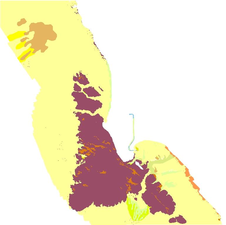
Potential marine benthic habitat maps were constructed using multibeam echosounder (MBES) bathymetry and backscatter data. The habitats were based on substrate types and documented or "ground truthed" using underwater video images and seafloor samples obtained by the USGS. These maps display various habitat types that range from flat, soft, unconsolidated sediment-covered seafloor to hard, deformed (folded), or highly rugose and differentially eroded bedrock exposures.
Purpose:
To expand geologic mapping to the seafloor within the California's State Waters, to update coastal geologic mapping, and to contribute to a uniform regional geologic database, which can be used geographic information systems. Additionally, to provide a geologic map for the public and geoscience community to aid in assessments and mitigation of geologic hazards in the Drakes Bay coastal region and to provide sufficient geologic information for land-use and land-management decisions both onshore and offshore. This information is not intended for navigational purposes.
Supplemental_Information:
References Cited:
Greene, H.G., Bizzarro, J.J., O'Connell, V.M., and Brylinsky, C.K., 2007, Construction of digital potential marine benthic habitat maps using a coded classification scheme and its application, in Todd, B.J., and Greene, H.G., eds., Mapping the seafloor for habitat characterization: Geological Association of Canada Special Paper 47, p. 141-155.
Greene, H.G., Yoklavich, M.M., Starr, R.M., O'Connell, V.M., Wakefield, W.W., Sullivan, D.E., McRea, J.E., Jr., and Cailliet, G.M., 1999, A classification scheme for deep seafloor habitats: Oceanologica Acta, v. 22, no. 6, p. 663-678.
Additional information about the field activity from which these data were derived is available online at:
https://cmgds.marine.usgs.gov/fan_info.php?fan=l908NC
Any use of trade, product, or firm names is for descriptive purposes only and does not imply endorsement by the U.S. Government.
Although this Federal Geographic Data Committee-compliant metadata file is intended to document the data set in nonproprietary form, as well as in Esri format, this metadata file may include some Esri-specific terminology.
Time_Period_of_Content:
Time_Period_Information:
Single_Date/Time:
Calendar_Date: 2014
Currentness_Reference: Publication Date
Status:
Progress: Complete
Maintenance_and_Update_Frequency: none planned
Spatial_Domain:
Bounding_Coordinates:
West_Bounding_Coordinate: -123.17
East_Bounding_Coordinate: -122.97
North_Bounding_Coordinate: 38.41
South_Bounding_Coordinate: 38.25
Keywords:
Theme:
Theme_Keyword_Thesaurus: USGS Metadata Identifier
Theme_Keyword: USGS:d23628e9-ddd5-4ab3-8ff5-beeb7f5d2a80
Theme:
Theme_Keyword_Thesaurus: ISO 19115 Topic Category
Theme_Keyword: geoscientificInformation
Theme_Keyword: environment
Theme_Keyword: oceans
Theme_Keyword: imageryBaseMapsEarthCover
Theme:
Theme_Keyword_Thesaurus: None
Theme_Keyword: Fisheries
Theme_Keyword: Ecosystem
Theme_Keyword: U.S. Geological Survey
Theme_Keyword: USGS
Theme_Keyword: Coastal and Marine Hazards and Resources
Theme_Keyword: CMHRP
Theme_Keyword: Pacific Coastal and Marine Science Center
Theme_Keyword: PCMSC
Theme:
Theme_Keyword_Thesaurus: Data Categories for Marine Planning
Theme_Keyword: distributions
Theme_Keyword: physical habitats and geomorphology
Theme_Keyword: habitat
Theme:
Theme_Keyword_Thesaurus: Marine Realms Information Bank (MRIB) keywords
Theme_Keyword: seabed
Theme_Keyword: habitats
Theme_Keyword: benthos
Theme:
Theme_Keyword_Thesaurus: USGS Thesaurus
Theme_Keyword: sea-floor characteristics
Theme_Keyword: habitats
Theme_Keyword: benthos
Theme_Keyword: ecosystems
Theme:
Theme_Keyword_Thesaurus: Coastal and Marine Ecological Classification Standard (CMECS)
Theme_Keyword: Marine Nearshore Subtidal
Theme_Keyword: Marine Offshore Subtidal
Theme_Keyword: Transform Continental Margin
Theme_Keyword: Continental/Island Shelf
Theme_Keyword: Rock Substrate
Theme_Keyword: Unconsolidated Mineral Substrate
Place:
Place_Keyword_Thesaurus: Geographic Names Information System (GNIS)
Place_Keyword: Pacific Ocean
Place_Keyword: State of California
Place_Keyword: Bodega Bay
Place_Keyword: Sonoma County
Place_Keyword: Salmon Creek
Place:
Place_Keyword_Thesaurus: Coastal and Marine Ecological Classification Standard (CMECS)
Place_Keyword: Northern California Ecoregion
Stratum:
Stratum_Keyword_Thesaurus: Coastal and Marine Ecological Classification Standard (CMECS)
Stratum_Keyword: Substrate
Access_Constraints: none
Use_Constraints:
USGS-authored or produced data and information are in the public domain from the U.S. Government and are freely redistributable with proper metadata and source attribution. Please recognize and acknowledge the Center for Habitat Studies, Moss Landing Marine Laboratories, and the U.S. Geological Survey as the originator(s) of the dataset and in products derived from these data. This information is not intended for navigation purposes.
Point_of_Contact:
Contact_Information:
Contact_Organization_Primary:
Contact_Organization:
U.S. Geological Survey, Pacific Coastal and Marine Science Center
Contact_Person: PCMSC Science Data Coordinator
Contact_Address:
Address_Type: mailing and physical
Address: 2885 Mission Street
City: Santa Cruz
State_or_Province: CA
Postal_Code: 95060-5792
Country: US
Contact_Voice_Telephone: 831-427-4747
Contact_Electronic_Mail_Address: pcmsc_data@usgs.gov
Browse_Graphic:
Browse_Graphic_File_Name: Browse_Graphic_File_Description: Benthic habitat offshore Bodega Head.
Browse_Graphic_File_Type: JPEG
Native_Data_Set_Environment:
Microsoft Windows 7 Version 6.1 (Build 7601) Service Pack 1; ESRI ArcGIS 10.0.3.3600
Cross_Reference:
Citation_Information:
Originator: Johnson, S.Y.
Originator: Dartnell, P.
Originator: Golden, N.E.
Originator: Hartwell, S.R.
Originator: Erdey, M.D.
Originator: Greene, H.G.
Originator: Cochrane, G.R.
Originator: Kvitek, R.G.
Originator: Manson, M.W.
Originator: Endris, C.A.
Originator: Dieter, B.E.
Originator: Watt, J.T.
Originator: Krisgman, L.M.
Originator: Sliter, R.W.
Originator: Lowe, E.N.
Originator: Chin, J.L.
Publication_Date: 2015
Title:
California State Waters Map Series--Offshore of Bodega Head, California
Series_Information:
Series_Name: Open-File Report
Issue_Identification: 2015-1140
Publication_Information:
Publication_Place: Reston, VA
Publisher: U.S. Geological Survey
Online_Linkage: https://doi.org/10.3133/ofr20151140
Data_Quality_Information:
Logical_Consistency_Report:
Map elements were visually checked for overshoots, undershoots, duplicate features, polygon closure, and other errors by the lead authors and by the GIS technician(s) who created the digital database. Review drafts of the map were reviewed internally by at least two other geologists for consistency with basic geologic principles and general conformity to USGS mapping standards.
Completeness_Report:
Contact authors for information about omissions, selection criteria, generalization, definitions used, and other rules used to derive the data set.
Positional_Accuracy:
Horizontal_Positional_Accuracy:
Horizontal_Positional_Accuracy_Report:
Interpretation and polygon delineation of habitats performed at scales from 1:2000 to 1:5000
Lineage:
Source_Information:
Source_Citation:
Citation_Information:
Originator: Peter Dartnell
Originator: Rikk G. Kvitek
Publication_Date: 2014
Title: Bathymetry--Offshore of Bodega Head, California
Geospatial_Data_Presentation_Form: raster digital data
Series_Information:
Series_Name: Data Series
Issue_Identification: DS 781
Publication_Information:
Publication_Place: Reston, VA
Publisher: U.S. Geological Survey
Other_Citation_Details:
See metadata for bathymetry ("Bathymetry_OffshoreBodegaHead_metadata.txt") in DS 781 for source data and postprocessing/reprocessing information.
Online_Linkage:
Type_of_Source_Media: digital file of gridded bathymetry data (ArcInfo GRID)
Source_Time_Period_of_Content:
Time_Period_Information:
Range_of_Dates/Times:
Beginning_Date: 2007
Ending_Date: 2010
Source_Currentness_Reference: ground condition
Source_Citation_Abbreviation: bathymetry
Source_Contribution: Gridded bathymetry data (2-meter resolution)
Source_Information:
Source_Citation:
Citation_Information:
Originator: Peter Dartnell
Originator: Rikk G. Kvitek
Publication_Date: 2014
Title: Backscatter--Offshore of Bodega Head, California
Geospatial_Data_Presentation_Form: raster digital data
Series_Information:
Series_Name: Data Series
Issue_Identification: DS 781
Publication_Information:
Publication_Place: Reston, VA
Publisher: U.S. Geological Survey
Other_Citation_Details:
See metadata for backscatter datasets ("BackscatterA_8101_OffshoreBodegaHead_metadata.txt", "BackscatterB_7125_OffshoreBodegaHead_metadata.txt" and "BackscatterC_Swath_OffshoreBodegaHead.txt") in DS 781 for amplitude source data and postprocessing/reprocessing information.
Online_Linkage: Online_Linkage: Online_Linkage:
Type_of_Source_Media: digital file of gridded amplitude data (ArcInfo GRID)
Source_Time_Period_of_Content:
Time_Period_Information:
Range_of_Dates/Times:
Beginning_Date: 2007
Ending_Date: 2010
Source_Currentness_Reference: ground condition
Source_Citation_Abbreviation: backscatter
Source_Contribution: Gridded backscatter amplitude data (2-meter resolution)
Source_Information:
Source_Citation:
Citation_Information:
Originator: Brian Edwards
Originator: Eleyne Phillips
Originator: Nadine Golden
Originator: Lisa Krigsman
Originator: Pete Dartnell
Publication_Date: 2014
Title: L908NC_video_observations
Series_Information:
Series_Name: Data Series
Issue_Identification: DS 781
Publication_Information:
Publication_Place: Reston, VA
Publisher: U.S. Geological Survey
Other_Citation_Details:
See metadata for L0908NC video observations ("l908nc_video_observations_metadata.txt") in DS 781 for source data and postprocessing/reprocessing information.
Online_Linkage:
Type_of_Source_Media: vector digital data
Source_Time_Period_of_Content:
Time_Period_Information:
Range_of_Dates/Times:
Beginning_Date: 20080811
Ending_Date: 20080822
Source_Currentness_Reference: ground condition
Source_Citation_Abbreviation: imagery
Source_Contribution:
seafloor interpretations from underwater video and sediment samples
Process_Step:
Process_Description:
Data used for the creation of the potential marine benthic habitat interpretation consists of multibeam bathymetry, acoustic backscatter, sediment samples, camera-sled imagery, and existing geologic and seafloor interpretive maps. All data were compiled and displayed for interpretation using ESRI ArcGIS software, ArcMap v.10.0. The process consists of editing a shapefile within ArcMap, beginning with the construction of polygons to delineate benthic features. A benthic feature is an area with common characteristics which can be characterized as a single potential habitat type. The boundaries and extents of these features were determined from the bathymetric data. In general, interpretations were made at scales between 1:2,000 and 1:5,000. The USGS kindly provided the Center for Habitat Studies with a geodatabase consisting of feature datasets delineating geologic features and attributes for Drakes Bay and vicinity. Some of the delineated polygons were preserved as part of the potential marine benthic habitat characterization. However, the Greene and others (2007) code was used in attributing the dataset and additional polygons were added using the methods outlined below. High-resolution multibeam sonar data in the form of bathymetric depth grids (seafloor digital elevation models, referred to as the "bathymetry") were the primary data used in the interpretation of potential habitat types. Shaded-relief imagery ("hillshade") allows for visualization of the terrain and interpretation of submarine landforms. On the basis of these hillshades, areas of rock were identified by their often sharply defined edges and high relative relief; these may be contiguous outcrops, isolated parts of outcrop protruding through sediment cover (pinnacles), or isolated boulders. Although these types of features can be confidently characterized as exposed rock, it is not uncommon to find areas within or around the rocky feature that appear to be covered by a thin veneer of sediment. These areas are identified as "mixed" induration, containing both rock and sediment. Broad areas of the seafloor lacking sharp and angular characteristics are considered to be sediment. Sedimentary features may contain erosional or depositional characteristics recognizable in the bathymetry, such as dynamic bedforms (dunes or sand waves). General morphologic features such as scours, mounds, and depressions were also identified using the hillshade imagery. The combination of acoustic backscatter data and "ground truthed" sediment samples were used to delineate seafloor sediment types within areas identified as "soft (s)" induration. Initially, ground truth data, in the form of grab sample descriptions and average grain size measurements, were categorized into four grain-size categories: mud (m), muddy sand (s/m), sand (s), and sandy gravel (s/g). Backscatter data was then classified into four intensity categories (low, med, high, very high) that are assumed to correspond to relative grain sizes. The aim was to develop an intensity classification of the seafloor that correlated with the data collected from the sediment samples. Thus, the combination of remotely observed data (acoustic backscatter) and directly observed data (sediment grab samples) translates to higher confidence in our ability to interpret broad areas of the seafloor. Nonetheless, we caution against using our sediment type interpretations as anything more than "best-guess" because of the following issues: characterization of contiguous sediment bodies is a difficult procedure because even small areas can exhibit a wide spectrum of backscatter-intensity values that lack distinct boundaries; backscatter intensity can be affected by depth, vegetation, water column conditions, and seafloor relief; and directly observed sediment data, in the form of sediment samples, represents a very small area relative to remotely observed data, requiring broad areas of interpolation.
Source_Used_Citation_Abbreviation: bathymetry
Source_Used_Citation_Abbreviation: backscatter
Source_Used_Citation_Abbreviation: imagery
Process_Date: 2014
Process_Step:
Process_Description:
Added Distribution_Information section to metadata to facilitate data download.
Process_Date: 20171005
Process_Contact:
Contact_Information:
Contact_Organization_Primary:
Contact_Organization: U.S. Geological Survey
Contact_Person: Alan O. Allwardt
Contact_Position: Contractor -- Information Specialist
Contact_Address:
Address_Type: mailing and physical address
Address: 2885 Mission Street
City: Santa Cruz
State_or_Province: CA
Postal_Code: 95060
Contact_Voice_Telephone: 831-460-7551
Contact_Facsimile_Telephone: 831-427-4748
Contact_Electronic_Mail_Address: aallwardt@usgs.gov
Process_Step:
Process_Description:
Keywords section of metadata optimized for discovery in USGS Coastal and Marine Geology Data Catalog.
Process_Date: 20171005
Process_Contact:
Contact_Information:
Contact_Organization_Primary:
Contact_Organization: U.S. Geological Survey
Contact_Person: Alan O. Allwardt
Contact_Position: Contractor -- Information Specialist
Contact_Address:
Address_Type: mailing and physical address
Address: 2885 Mission Street
City: Santa Cruz
State_or_Province: CA
Postal_Code: 95060
Contact_Voice_Telephone: 831-460-7551
Contact_Facsimile_Telephone: 831-427-4748
Contact_Electronic_Mail_Address: aallwardt@usgs.gov
Process_Step:
Process_Description:
Added keywords from Coastal and Marine Ecological Classification Standard (CMECS) to metadata.
Process_Date: 20180426
Process_Contact:
Contact_Information:
Contact_Organization_Primary:
Contact_Organization: U.S. Geological Survey
Contact_Person: Alan O. Allwardt
Contact_Position: Contractor -- Information Specialist
Contact_Address:
Address_Type: mailing and physical address
Address: 2885 Mission Street
City: Santa Cruz
State_or_Province: CA
Postal_Code: 95060
Contact_Voice_Telephone: 831-460-7551
Contact_Facsimile_Telephone: 831-427-4748
Contact_Electronic_Mail_Address: aallwardt@usgs.gov
Process_Step:
Process_Description:
Edited metadata to add keywords section with USGS persistent identifier as theme keyword. No data were changed.
Process_Date: 20201019
Process_Contact:
Contact_Information:
Contact_Organization_Primary:
Contact_Organization: U.S. Geological Survey
Contact_Person: VeeAnn A. Cross
Contact_Position: Marine Geologist
Contact_Address:
Address_Type: Mailing and Physical
Address: 384 Woods Hole Road
City: Woods Hole
State_or_Province: MA
Postal_Code: 02543-1598
Contact_Voice_Telephone: 508-548-8700 x2251
Contact_Facsimile_Telephone: 508-457-2310
Contact_Electronic_Mail_Address: vatnipp@usgs.gov
Process_Step:
Process_Description:
Edited metadata to fix validation errors and to bring it up to FGDC CSDGM current standards based on data release policies for USGS Coastal and Marine Hazards and Resources Program (CMHRP). No data were changed. The metadata available from a harvester may supersede metadata bundled within a download file. Users are advised to compare the metadata dates to determine which metadata file is most recent.
Process_Date: 20220725
Process_Contact:
Contact_Information:
Contact_Organization_Primary:
Contact_Organization: U.S. Geological Survey
Contact_Person: Susan Cochran
Contact_Position: Geologist
Contact_Address:
Address_Type: Mailing and Physical
Address: 2885 Mission Street
City: Santa Cruz
State_or_Province: CA
Postal_Code: 95060
Contact_Voice_Telephone: 831-460-7545
Contact_Electronic_Mail_Address: scochran@usgs.gov
Spatial_Data_Organization_Information:
Direct_Spatial_Reference_Method: Vector
Point_and_Vector_Object_Information:
SDTS_Terms_Description:
SDTS_Point_and_Vector_Object_Type: GT-polygon composed of chains
Point_and_Vector_Object_Count: 963
Spatial_Reference_Information:
Horizontal_Coordinate_System_Definition:
Planar:
Map_Projection:
Map_Projection_Name: WGS 1984 UTM Zone 10N
Transverse_Mercator:
Scale_Factor_at_Central_Meridian: 0.9996
Longitude_of_Central_Meridian: -123.0
Latitude_of_Projection_Origin: 0.0
False_Easting: 500000.0
False_Northing: 0.0
Planar_Coordinate_Information:
Planar_Coordinate_Encoding_Method: coordinate pair
Coordinate_Representation:
Abscissa_Resolution: 2
Ordinate_Resolution: 2
Planar_Distance_Units: Meter
Geodetic_Model:
Horizontal_Datum_Name: D WGS 1984
Ellipsoid_Name: WGS 1984
Semi-major_Axis: 6378137.0
Denominator_of_Flattening_Ratio: 298.257223563
Entity_and_Attribute_Information:
Detailed_Description:
Entity_Type:
Entity_Type_Label: Habitat_OffshoreBodegaHead
Entity_Type_Definition: Polygons representing habitat map units
Entity_Type_Definition_Source: This report
Attribute:
Attribute_Label: OBJECTID
Attribute_Definition: Internal feature number.
Attribute_Definition_Source: ESRI
Attribute_Domain_Values:
Unrepresentable_Domain:
Sequential unique whole numbers that are automatically generated.
Attribute:
Attribute_Label: Shape
Attribute_Definition: Feature geometry.
Attribute_Definition_Source: ESRI
Attribute_Domain_Values:
Unrepresentable_Domain: Coordinates defining the features.
Attribute:
Attribute_Label: Hab_Code
Attribute_Definition: Habitat code
Attribute_Definition_Source: Center for Habitat Studies, Greene and others (1999, 2007)
Attribute_Domain_Values:
Unrepresentable_Domain: Names are in text form, maximum length: 25
Attribute:
Attribute_Label: Hab_Type
Attribute_Definition: Habitat type
Attribute_Definition_Source: Center for Habitat Studies, Greene and others (1999, 2007)
Attribute_Domain_Values:
Unrepresentable_Domain: Names are in text form, maximum length: 100
Attribute:
Attribute_Label: Mega_ID
Attribute_Definition: Megahabitat ID code
Attribute_Definition_Source: Center for Habitat Studies, Greene and others (1999, 2007)
Attribute_Domain_Values:
Unrepresentable_Domain: Names are in text form, maximum length: 10
Attribute:
Attribute_Label: Mega
Attribute_Definition: Megahabitat description
Attribute_Definition_Source: Center for Habitat Studies, Greene and others (1999, 2007)
Attribute_Domain_Values:
Unrepresentable_Domain: Names are in text form, maximum length: 35
Attribute:
Attribute_Label: Ind_ID
Attribute_Definition: Seafloor induration ID code
Attribute_Definition_Source: Center for Habitat Studies, Greene and others (1999, 2007)
Attribute_Domain_Values:
Unrepresentable_Domain: Names are in text form, maximum length: 10
Attribute:
Attribute_Label: Ind
Attribute_Definition: Seafloor induration description
Attribute_Definition_Source: Center for Habitat Studies, Greene and others (1999, 2007)
Attribute_Domain_Values:
Unrepresentable_Domain: Names are in text form, maximum length: 35
Attribute:
Attribute_Label: Sed_ID
Attribute_Definition: Sediment ID code
Attribute_Definition_Source: Center for Habitat Studies, Greene and others (1999, 2007)
Attribute_Domain_Values:
Unrepresentable_Domain: Names are in text form, maximum length: 10
Attribute:
Attribute_Label: Sed
Attribute_Definition: Sediment description
Attribute_Definition_Source: Center for Habitat Studies, Greene and others (1999, 2007)
Attribute_Domain_Values:
Unrepresentable_Domain: Names are in text form, maximum length: 35
Attribute:
Attribute_Label: Mes_Mac_ID
Attribute_Definition: Meso/Macro-habitat ID code
Attribute_Definition_Source: Center for Habitat Studies, Greene and others (1999, 2007)
Attribute_Domain_Values:
Unrepresentable_Domain: Names are in text form, maximum length: 15
Attribute:
Attribute_Label: Mes_Mac
Attribute_Definition: Meso/Macro-habitat description
Attribute_Definition_Source: Center for Habitat Studies, Greene and others (1999, 2007)
Attribute_Domain_Values:
Unrepresentable_Domain: Names are in text form, maximum length: 50
Attribute:
Attribute_Label: Mod_ID
Attribute_Definition: Habitat modifier ID code
Attribute_Definition_Source: Center for Habitat Studies, Greene and others (1999, 2007)
Attribute_Domain_Values:
Unrepresentable_Domain: Names are in text form, maximum length: 15
Attribute:
Attribute_Label: Mod
Attribute_Definition: Habitat modifier description
Attribute_Definition_Source: Center for Habitat Studies, Greene and others (1999, 2007)
Attribute_Domain_Values:
Unrepresentable_Domain: Names are in text form, maximum length: 50
Attribute:
Attribute_Label: Hab_Desc
Attribute_Definition: Habitat Description
Attribute_Definition_Source: Center for Habitat Studies, Greene and others (1999, 2007)
Attribute_Domain_Values:
Unrepresentable_Domain: Names are in text form, maximum length: 200
Attribute:
Attribute_Label: Area
Attribute_Definition: Polygon area in meters
Attribute_Definition_Source: ESRI Calculate Geometry (Area in square meters) tool
Attribute_Domain_Values:
Range_Domain:
Range_Domain_Minimum: 34.819099
Range_Domain_Maximum: 62299230.1744
Attribute_Units_of_Measure: Float values in square meters
Distribution_Information:
Distributor:
Contact_Information:
Contact_Organization_Primary:
Contact_Organization: U.S. Geological Survey
Contact_Address:
Address_Type: mailing and physical address
Address: 345 Middlefield Rd
City: Menlo Park
State_or_Province: CA
Postal_Code: 94025-3561
Country: USA
Contact_Voice_Telephone: (650) 329-4309
Resource_Description:
The .zip file (Habitat_OffshoreBodegaHead.zip) includes the .aux, .dbf, .shp, .shx, .sbx, and .sbn files, as well as FGDC-compliant metadata for the habitats data layer of Offshore Bodega Head, California.
Distribution_Liability:
Unless otherwise stated, all data, metadata and related materials are considered to satisfy the quality standards relative to the purpose for which the data were collected. Although these data and associated metadata have been reviewed for accuracy and completeness and approved for release by the U.S. Geological Survey (USGS), no warranty expressed or implied is made regarding the display or utility of the data on any other system or for general or scientific purposes, nor shall the act of distribution constitute any such warranty.
Standard_Order_Process:
Digital_Form:
Digital_Transfer_Information:
Format_Name: shapefile
Format_Version_Number: ArcMap (version 10.0, ESRI, 2011)
Format_Specification:
Point, line, and polygon features are in shapefile format and are projected in UTM Zone 10 coordinates.
Format_Information_Content:
The .zip file includes the .aux, .dbf, .shp, .shx, .sbx, and .sbn files, as well as FGDC-compliant metadata for the habitats data layer of Drakes Bay and vicinity, California.
File_Decompression_Technique: WinZip
Transfer_Size: 0.6
Digital_Transfer_Option:
Online_Option:
Computer_Contact_Information: Access_Instructions:
The first link will begin a direct download of the data. The second link is a landing page on which all of the downloadable data for a particular region are listed. The third link is a landing page for the entire data catalog.
Fees: none
Metadata_Reference_Information:
Metadata_Date: 20220725
Metadata_Contact:
Contact_Information:
Contact_Organization_Primary:
Contact_Organization:
U.S. Geological Survey, Pacific Coastal and Marine Science Center
Contact_Person: PCMSC Science Data Coordinator
Contact_Address:
Address_Type: mailing and physical
Address: 2885 Mission Street
City: Santa Cruz
State_or_Province: CA
Postal_Code: 95060-5792
Country: US
Contact_Voice_Telephone: 831-427-4747
Contact_Electronic_Mail_Address: pcmsc_data@usgs.gov
Metadata_Standard_Name: Content Standard for Digital Geospatial Metadata
Metadata_Standard_Version: FGDC-STD-001-1998
Metadata_Time_Convention: local time

Generated by mp version 2.9.52 on Mon Jul 25 22:35:52 2022