Folds--Offshore of San Gregorio Map Area, California

Metadata also available as - [Outline] - [Parseable text] - [XML]

Frequently anticipated questions:


What does this data set describe?

Title: Folds--Offshore of San Gregorio Map Area, California
Abstract:
This part of SIM 3306 presents data for the folds for the geologic and geomorphic map (see sheet 10, SIM 3306) of the Offshore of San Gregorio map area, California. The vector data file is included in "Folds_OffshoreSanGregorio.zip," which is accessible from <https://pubs.usgs.gov/ds/781/OffshoreSanGregorio/data_catalog_OffshoreSanGregorio.html>.
The offshore San Gregorio map area lies about 15 to 25 km southwest of the San Andreas Fault, the dominant structure in the distributed transform boundary between the North American and Pacific plates. The map area straddles the right-lateral San Gregorio Fault zone, a prominent structure west of the San Andreas Fault in the broader San Andreas Fault system. The San Gregorio Fault zone occurs predominantly in the offshore and extends 400 km from Point Conception on the south to Bolinas and Point Reyes on the north (Dickinson and others, 2005), coming onland at coastal promontories such as Pescadero Point in the map area and Pillar Point, a few km north of Half Moon Bay (sheet 9). In the offshore, the San Gregorio Fault system forms a distributed shear zone about 2 to 4 km wide that includes two main diverging fault strands. The western strand (also known as the Frijoles Fault) extends offshore from Pescadero Point. The eastern strand (also known as the Coastways Fault or Seal Cove Fault), is mostly onshore in this map area. Cumulative lateral slip on the San Gregorio Fault zone is thought to range from 4 to 10 mm/yr in this region (U.S. Geological Survey, 2010). The western strand of the San Gregorio Fault zone (i.e., Frijoles Fault) forms the eastern boundary of the Pigeon Point high.
References Cited
Dickinson, W.R., Ducea, M., Rosenberg, L.I., Greene, H.G., Graham, S.A., Clark, J.C., Weber, G.E., Kidder, S., Ernst, W.G., and Brabb, E.E., 2005, Net dextral slip, Neogene San Gregorio-Hosgri fault zone, coastal California: Geologic evidence and tectonic implications: Geological Society of America Special Paper 391, 43 p.
Supplemental_Information:
Map political location: San Mateo County, California Compilation scale: 1:24,000 Base maps used are hillshades generated from IfSAR, LiDAR, and multibeam mapping both onshore and offshore (see sheet 2, SIM 3306, for more information).
  1. How should this data set be cited?

    Watt, J.T., Greene, H.G., Hartwell, S.R., Endris, C.A., Ross, S.L., Phillips, E.L., and Dieter, B.E., 2013, Folds--Offshore of San Gregorio Map Area, California:.

    This is part of the following larger work.

    Cochrane, Guy R., Dartnell, Peter, Greene, H. Gary, Watt, Janet T., Golden, Nadine E., Endris, Charles A., Phillips, Eleyne L., Hartwell, Stephen R., Johnson, Samuel Y., Kvitek, Rikk G., Erdey, Mercedes D., Bretz, Carrie .K., Mansion, Michael W., Sliter, Ray W., Ross, Stephanie L., Dieter, Brian E., and Chin, John L., 2014, California State Waters Map Series--Offshore of San Gregorio Map Area, California: Scientific Investigations Map SIM 3306, U.S. Geological Survey, Reston, VA.

    Online Links:

  2. What geographic area does the data set cover?

    West_Bounding_Coordinate: -122.492163
    East_Bounding_Coordinate: -122.401585
    North_Bounding_Coordinate: 37.391508
    South_Bounding_Coordinate: 37.229776

  3. What does it look like?

    <https://pubs.usgs.gov/ds/781/OffshoreSanGregorio/images/Folds_OffshoreSanGregorio.jpg> (JPEG)
    Folds offshore San Gregorio.

  4. Does the data set describe conditions during a particular time period?

    Beginning_Date: 2007
    Ending_Date: 2010
    Currentness_Reference: ground condition

  5. What is the general form of this data set?

    Geospatial_Data_Presentation_Form: vector digital data

  6. How does the data set represent geographic features?

    1. How are geographic features stored in the data set?

      This is a Vector data set. It contains the following vector data types (SDTS terminology):

      • String

    2. What coordinate system is used to represent geographic features?

      The map projection used is WGS 1984 UTM Zone 10N.

      Projection parameters:
      Scale_Factor_at_Central_Meridian: 0.9996
      Longitude_of_Central_Meridian: -123.0
      Latitude_of_Projection_Origin: 0.0
      False_Easting: 500000.0
      False_Northing: 0.0

      Planar coordinates are encoded using coordinate pair
      Abscissae (x-coordinates) are specified to the nearest 0.0001
      Ordinates (y-coordinates) are specified to the nearest 0.0001
      Planar coordinates are specified in Meter

      The horizontal datum used is D WGS 1984.
      The ellipsoid used is WGS 1984.
      The semi-major axis of the ellipsoid used is 6378137.0.
      The flattening of the ellipsoid used is 1/298.257223563.

  7. How does the data set describe geographic features?

    Folds
    lines representing mapped folds (Source: This report)

    FID
    Internal feature number. (Source: ESRI)

    Sequential unique whole numbers that are automatically generated.

    Shape
    Feature geometry. (Source: ESRI)

    Coordinates defining the features.

    FGDCRefNo
    FGDC Digital Cartographic Standard for geologic map symbolization (Source: This report)

    text field containing the reference number for the FGDC Digital Cartographic Standard for geologic map symbolization

    Shape_Length
    Length of feature in internal units. (Source: ESRI)

    Positive real numbers that are automatically generated.


Who produced the data set?

  1. Who are the originators of the data set? (may include formal authors, digital compilers, and editors)

  2. Who also contributed to the data set?

  3. To whom should users address questions about the data?

    USGS Pacific Coastal and Marine Science Center
    Attn: Stephen Hartwell
    Geologist
    400 Natural Bridges Drive
    Santa Cruz, CA 95060
    USA

    (831) 460-7814 (voice)
    (831) 427-4748 (FAX)
    shartwell@usgs.gov


Why was the data set created?

To expand geologic mapping to the seafloor within the California's State Waters, to update coastal geologic mapping, and to contribute to a uniform regional geologic database. Additionally, to provide a geologic map for the public and geoscience community to aid in assessments and mitigation of geologic hazards in the San Gregorio coastal region and to provide sufficient geologic information for land-use and land-management decisions both onshore and offshore. This information is not intended for navigational purposes


How was the data set created?

  1. From what previous works were the data drawn?

    S-15-10-NC (source 1 of 2)
    U.S. Geological Survey (USGS) , Coastal and Marine Geology Program (CMGP), 2013, Seismic-reflection data acquisition data of field activity S-15-10-NC in offshore Pescadero from 08/02/2010 to 08/04/2010: U.S. Geological Survey (USGS) , Coastal and Marine Geology (CMG), Menlo Park, CA.

    Online Links:

    Type_of_Source_Media: ASCII lat/long shot point files
    Source_Contribution:
    Digital seismic data used to interpret subsurface geologic structure

    F-2-07-NC (source 2 of 2)
    U.S. Geological Survey (USGS) , Coastal and Marine Geology Program (CMGP), 2013, Geophysical data of field activity F-2-07-NC in Ano Nuevo to San Francisco from 03/22/2007 to 04/06/2007: U.S. Geological Survey (USGS) , Coastal and Marine Geology (CMG), Menlo Park, CA.

    Online Links:

    Type_of_Source_Media: ASCII lat/long shot point files
    Source_Contribution:
    Digital seismic data used to interpret subsurface geologic structure

  2. How were the data generated, processed, and modified?

    Date: 2010 (process 1 of 2)
    Folds were mapped onto shot lines based on the latitude and longitude of seismic picks from field activity S-15-10-NC.

    Date: 2011 (process 2 of 2)
    Folds were mapped onto shot lines based on the latitude and longitude of seismic picks from field activity F-2-07-NC.

  3. What similar or related data should the user be aware of?


How reliable are the data; what problems remain in the data set?

  1. How well have the observations been checked?

  2. How accurate are the geographic locations?

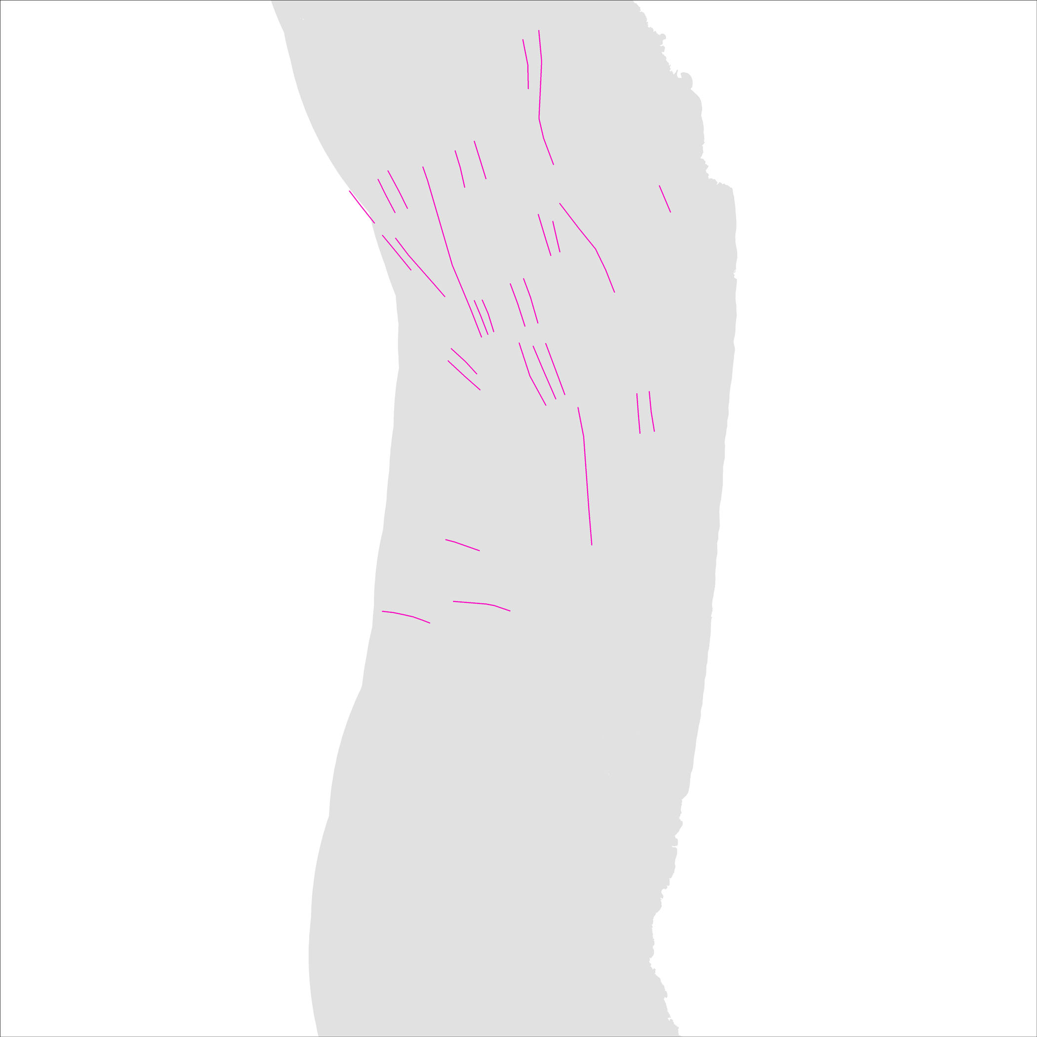
    Folds were primarily mapped by interpretation of seismic reflection profile data (see sheet 8, SIM 3306).
    Folds lines were digitized by heads-up screen digitization on to shot point picks from seismic line navigation data - each shot point has an associated lat/long in the survey data. Error is introduced from layback, as well as from interpretation of oblique features, so horizontal accuracy of fault and fold location is estimated to be on the order of 10 to 20 meters.

  3. How accurate are the heights or depths?

  4. Where are the gaps in the data? What is missing?

    Data are complete: no offshore features that could be accurately identified and represented at the compilation scale of 1:24,000 were eliminated or generalized. The smallest area represented is approximately 100 square meters. All geospatial database elements are attributed.

  5. How consistent are the relationships among the observations, including topology?

    Map elements were visually checked for overshoots, undershoots, duplicate features, and other errors by the lead authors and by the GIS technician(s) who created the digital database. Review drafts of the map were reviewed internally by at least two other geologists for consistency with basic geologic principles and general conformity to USGS mapping standards.


How can someone get a copy of the data set?

Are there legal restrictions on access or use of the data?

Access_Constraints:
If physical samples or materials are available, constraints on their on-site access are described in "WR CMG Sample Distribution Policy" at URL: <http://walrus.wr.usgs.gov/infobank/programs/html/main/sample-dist-policy.html>
Use_Constraints:
This information is not intended for navigational purposes.
Read and fully comprehend the metadata prior to data use. Uses of these data should not violate the spatial resolution of the data. Where these data are used in combination with other data of different resolution, the resolution of the combined output will be limited by the lowest resolution of all the data.
Acknowledge the U.S. Geological Survey in products derived from these data. Share data products developed using these data with the U.S. Geological Survey.
This database has been approved for release and publication by the Director of the USGS. Although this database has been subjected to rigorous review and is substantially complete, the USGS reserves the right to revise the data pursuant to further analysis and review. Furthermore, it is released on condition that neither the USGS nor the United States Government may be held liable for any damages resulting from its authorized or unauthorized use.
Although this Federal Geographic Data Committee-compliant metadata file is intended to document these data in nonproprietary form, as well as in ArcInfo format, this metadata file may include some ArcInfo-specific terminology.


Who wrote the metadata?

Dates:
Last modified: 2013
Metadata author:
U.S. Geological Survey, Coastal and Marine Geology Program
Attn: Stephen R. Hartwell
400 Natural Bridges Drive
Santa Cruz, CA 95060-5792
US

831-460-7814 (voice)
831-427-4748 (FAX)
shartwell@usgs.gov

Metadata standard:
FGDC Content Standard for Digital Geospatial Metadata (FGDC-STD-001-1998)