Isopachs--Salt Point to Drakes Bay, California

Metadata also available as - [Questions & Answers] - [Parseable text] - [XML]

Metadata:


Identification_Information:
Citation:
Citation_Information:
Originator: Samuel Y. Johnson
Originator: Stephen R. Hartwell
Originator: Janet T. Watt
Originator: Ray W. Sliter
Publication_Date: 2014
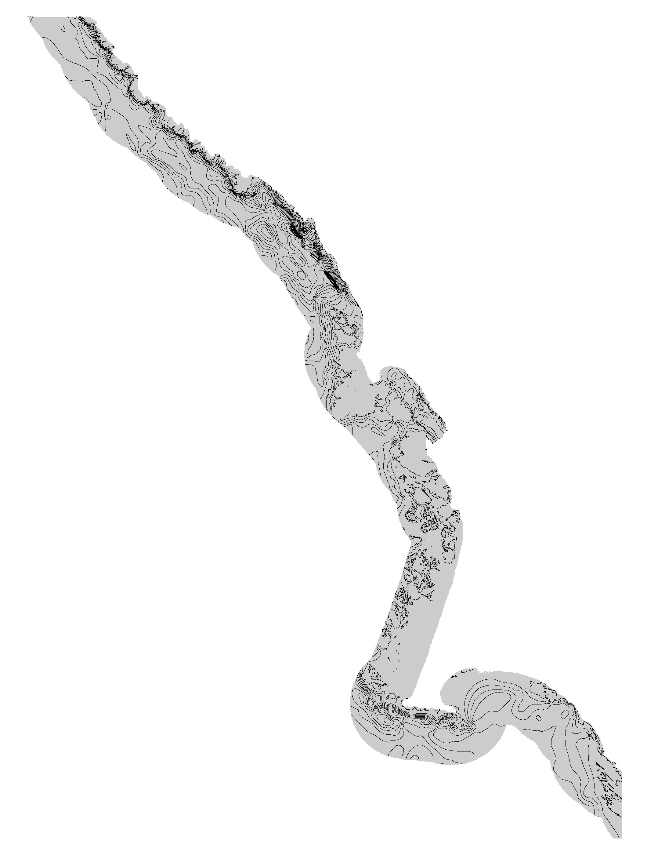
Title: Isopachs--Salt Point to Drakes Bay, California
Geospatial_Data_Presentation_Form: Vector digital data
Larger_Work_Citation:
Citation_Information:
Originator: Nadine E. Golden
Publication_Date: 2013
Title: California State Waters Map Series Data Catalog
Geospatial_Data_Presentation_Form: database
Series_Information:
Series_Name: Data Series
Issue_Identification: DS 781
Publication_Information:
Publication_Place: Reston, VA
Publisher: U.S. Geological Survey
Online_Linkage: <https://pubs.usgs.gov/ds/781/>

Description:
Abstract:

This part of DS 781 presents data for the isopachs for the Salt Point to Drakes Bay, California, region. The vector data file is included in "Isopachs_SaltPointToDrakesBay.zip," which is accessible from <https://pubs.usgs.gov/ds/781/SaltPointToDrakesBay/data_catalog_SaltPointToDrakesBay.html>.
As part of the USGS's California Seafloor Mapping Program, a 20-m grid ofsediment thickness for the seafloor within the 3-nautical-mile limit of California's State Waters between Salt Point and Drakes Bay was generated from seismic-reflection data collected in 2009 (USGS activity (S-8-09-NC) supplemented with outcrop and geologic structure from sheet DS 781. The resulting grid covers an area of approximately 600 sq km. The volume of sediment accumulated since the Last Glacial Maximum is approximately 9,000 million cubic meters. Contours at 2.5-meter intervals were derived from this grid.
Purpose:
These data are intended for science researchers, students, policy makers, and the general public. This information is not intended for navigational purposes. The data can be used with geographic information systems (GIS) software to display geologic and oceanographic information.

Supplemental_Information:
Sediment thickness and volume within each of the map areas
 Salt Point    38.639622 38.479620 -123.482704 -123.278809
 Fort Ross     38.556494 38.396794 -123.305678 -123.102404
 Bodega Bay    38.411542 38.252067 -123.172536 -122.969899
 Tomales Point 38.255180 38.095716 -123.097226 -122.895023
 Point Reyes   38.098263 37.938810 -123.094511 -122.892742
 Drakes Bay    38.038192 37.878737 -122.966411 -122.764735

   -----sediment thickness--------
                  Area            Volume
  Map block      (sq km)  Mean  (million cu m)
  Salt Point      117     12.5      1464
  Fort Ross       100     21.5      2157
  Bodega Bay      128      8.5      1084
  Tomales Point   108      2.1       230
  Point Reyes     175      7.9      1387
  Drakes Bay       89      5.3       476
Additional information about the field activities from which this data set was derived are available online at
 <http://walrus.wr.usgs.gov/infobank/s/s809nc/html/s-8-09-nc.meta.html>
Any use of trade, product, or firm names is for descriptive purposes only and does not imply endorsement by the U.S. Government.
Although this Federal Geographic Data Committee-compliant metadata file is intended to document the data set in nonproprietary form, as well as in ArcInfo format, this metadata file may include some ArcInfo-specific terminology.
Time_Period_of_Content:
Time_Period_Information:
Single_Date/Time:
Calendar_Date: 2009
Currentness_Reference: ground condition
Status:
Progress: Complete
Maintenance_and_Update_Frequency: None planned
Spatial_Domain:
Bounding_Coordinates:
West_Bounding_Coordinate: -123.473993
East_Bounding_Coordinate: -122.762732
North_Bounding_Coordinate: 38.640196
South_Bounding_Coordinate: 37.868433
Keywords:
Theme:
Theme_Keyword_Thesaurus: None
Theme_Keyword: marine geology
Theme_Keyword: coastal geology
Theme_Keyword: sediment thickness
Theme_Keyword: sediment isopach
Theme_Keyword: seismic-reflection data
Theme:
Theme_Keyword_Thesaurus: ISO 19115 Topic Category
Theme_Keyword: environment
Theme_Keyword: geoscientificInformation
Theme_Keyword: oceans
Place:
Place_Keyword_Thesaurus: Geographic Names Information System
Place_Keyword: Pacific Ocean
Place_Keyword: State of California
Place_Keyword: Bodega Bay
Place_Keyword: Marin County
Place_Keyword: Sonoma County
Place_Keyword: Point Reyes
Access_Constraints:
If physical samples or materials are available, constraints on their on-site access are described in "WR CMG Sample Distribution Policy" at URL: <http://walrus.wr.usgs.gov/infobank/programs/html/main/sample-dist-policy.html>
Use_Constraints:
This information is not intended for navigational purposes.

Read and fully comprehend the metadata prior to data use. Uses of these data should not violate the spatial resolution of the data. Where these data are used in combination with other data of different resolution, the resolution of the combined output will be limited by the lowest resolution of all the data.

Acknowledge the U.S. Geological Survey in products derived from these data. Share data products developed using these data with the U.S. Geological Survey.

This database has been approved for release and publication by the Director of the USGS. Although this database has been subjected to rigorous review and is substantially complete, the USGS reserves the right to revise the data pursuant to further analysis and review. Furthermore, it is released on condition that neither the USGS nor the United States Government may be held liable for any damages resulting from its authorized or unauthorized use.

Although this Federal Geographic Data Committee-compliant metadata file is intended to document these data in nonproprietary form, as well as in ArcInfo format, this metadata file may include some ArcInfo-specific terminology.
Point_of_Contact:
Contact_Information:
Contact_Organization_Primary:
Contact_Organization: U.S. Geological Survey, Coastal and Marine Geology Program
Contact_Person: Stephen Hartwell
Contact_Position: Geologist
Contact_Address:
Address_Type: physical address
Address: 400 Natural Bridges Drive
City: Santa Cruz
State_or_Province: CA
Postal_Code: 95060
Country: USA
Contact_Voice_Telephone: (831) 460-7814
Contact_Facsimile_Telephone: (831) 427-4748
Contact_Electronic_Mail_Address: shartwell@usgs.gov
Browse_Graphic:
Browse_Graphic_File_Name:
<https://pubs.usgs.gov/ds/781/SaltPointToDrakesBay/images/Isopachs_SaltPointToDrakesBay.jpg>
Browse_Graphic_File_Description: map of sediment thickness contours
Browse_Graphic_File_Type: JPEG
Native_Data_Set_Environment:
Microsoft Windows Server 2008 R2 Version 6.1 (Build 7601) Service Pack 1; ESRI ArcCatalog 10.0

Data_Quality_Information:
Attribute_Accuracy:
Attribute_Accuracy_Report:
Data points are approximately 1 m apart along tracklines and 1000-2000 m apart between tracks. 50-m cell size for interpolation is better supported along track than between.
Logical_Consistency_Report: All vector geometry and attributes present.
Completeness_Report:
Sediment thickness data points exported from Seisworks profiling software were processed within the California 3-nmi limit.
Positional_Accuracy:
Horizontal_Positional_Accuracy:
Horizontal_Positional_Accuracy_Report:
The chirp sonar instrument is deployed under the research vessel with about 10m of variation in position. The sparker position may vary as much as 20m from the navigation reference on the vessel.
Vertical_Positional_Accuracy:
Vertical_Positional_Accuracy_Report:
Estimated to be approximately 1 m, along the track lines where data is well constrained, but may be much greater in areas where interpolation occurred.
Lineage:
Source_Information:
Source_Citation:
Citation_Information:
Originator:
U.S. Geological Survey (USGS) , Coastal and Marine Geology Program (CMGP)
Publication_Date: 2013
Title:
Seismic-reflection data acquisition data of field activity S-8-09-NC Stinson Beach to point Arena 09/08/2009 to 09/30/2009
Publication_Information:
Publication_Place: Menlo Park, CA
Publisher:
U.S. Geological Survey (USGS) , Coastal and Marine Geology (CMG)
Online_Linkage: <http://walrus.wr.usgs.gov/infobank/gos/s-8-09-nc.fmeta.xml>
Online_Linkage:
<http://walrus.wr.usgs.gov/infobank/s/s809nc/html/s-8-09-nc.meta.html>
Type_of_Source_Media: ASCII lat/long shot point files
Source_Time_Period_of_Content:
Time_Period_Information:
Range_of_Dates/Times:
Beginning_Date: 20090908
Ending_Date: 20090930
Source_Currentness_Reference: ground condition
Source_Citation_Abbreviation: S-8-09-NC
Source_Contribution:
Digital seismic data used to interpret subsurface geologic structure
Process_Step:
Process_Description:
Chirp and sparker seismic-reflection data from USGS field activity S-8-09-NC were imported to SEISWORKS.
Process_Date: 2013
Process_Step:
Process_Description:
Seabed and depth to Last Glacial Maximum horizons digitized in Seisworks.
Process_Date: 2013
Process_Step:
Process_Description:
Data exported and converted with 1500m/sec velocity in water and 1600 m/sec velocity in sediment.
Process_Date: 2013
Process_Step:
Process_Description:
X, Y locations and sediment thickness value Z imported to ArcGIS format as points, interpolated to preliminary surface with TopoRaster. Supplemental manually generated contours were combined for secondary calculation.
Process_Date: 2013
Process_Step:
Process_Description: Sediment thickness grid contoured at 2.5-meter intervals.
Process_Date: 2013

Spatial_Data_Organization_Information:
Direct_Spatial_Reference_Method: Vector
Point_and_Vector_Object_Information:
SDTS_Terms_Description:
SDTS_Point_and_Vector_Object_Type: String
Point_and_Vector_Object_Count: 1147

Spatial_Reference_Information:
Horizontal_Coordinate_System_Definition:
Planar:
Grid_Coordinate_System:
Grid_Coordinate_System_Name: Universal Transverse Mercator
Universal_Transverse_Mercator:
UTM_Zone_Number: 10
Transverse_Mercator:
Scale_Factor_at_Central_Meridian: 0.999600
Longitude_of_Central_Meridian: -117.000000
Latitude_of_Projection_Origin: 0.000000
False_Easting: 500000.000000
False_Northing: 0.000000
Planar_Coordinate_Information:
Planar_Coordinate_Encoding_Method: row and column
Coordinate_Representation:
Abscissa_Resolution: 20.000000
Ordinate_Resolution: 20.000000
Planar_Distance_Units: meters
Geodetic_Model:
Horizontal_Datum_Name: D_WGS_1984
Ellipsoid_Name: WGS_1984
Semi-major_Axis: 6378137.000000
Denominator_of_Flattening_Ratio: 298.257224

Entity_and_Attribute_Information:
Detailed_Description:
Entity_Type:
Entity_Type_Label: isopachs
Entity_Type_Definition: lines of equal thickness
Entity_Type_Definition_Source: standard sedimentology
Attribute:
Attribute_Label: FID
Attribute_Definition: Internal feature number.
Attribute_Definition_Source: ESRI
Attribute_Domain_Values:
Unrepresentable_Domain:
Sequential unique whole numbers that are automatically generated.
Attribute:
Attribute_Label: Shape
Attribute_Definition: Feature geometry.
Attribute_Definition_Source: ESRI
Attribute_Domain_Values:
Unrepresentable_Domain: Coordinates defining the features.
Attribute:
Attribute_Label: ID
Attribute_Definition: sequential feature number
Attribute_Definition_Source: this study
Attribute_Domain_Values:
Unrepresentable_Domain: sequential feature numbers
Attribute:
Attribute_Label: CONTOUR
Attribute_Definition: line of equal thickness
Attribute_Definition_Source: this study
Attribute_Domain_Values:
Unrepresentable_Domain: thickness measure
Attribute:
Attribute_Label: Type
Attribute_Definition: Type of contour
Attribute_Definition_Source: This report
Attribute_Domain_Values:
Enumerated_Domain:
Enumerated_Domain_Value: Index
Enumerated_Domain_Value_Definition: Contour at 10m interval
Enumerated_Domain_Value_Definition_Source: This report
Attribute_Domain_Values:
Enumerated_Domain:
Enumerated_Domain_Value: Intermediate
Enumerated_Domain_Value_Definition: Contours at 2.5m interval
Enumerated_Domain_Value_Definition_Source: This report

Distribution_Information:
Distributor:
Contact_Information:
Contact_Organization_Primary:
Contact_Organization: U.S. Geological Survey, Coastal and Marine Geology Program
Contact_Person: Stephen Hartwell
Contact_Position: Geologist
Contact_Address:
Address_Type: physical address
Address: 400 Natural Bridges Drive
City: Santa Cruz
State_or_Province: CA
Postal_Code: 95060
Country: USA
Contact_Voice_Telephone: (831) 460-7814
Contact_Facsimile_Telephone: (831) 427-4748
Contact_Electronic_Mail_Address: shartwell@usgs.gov
Distribution_Liability:
These databases, identified as isopachs for the Salt Point to Drakes Bay Region, California have been approved for release and publication by the U.S. Geological Survey (USGS). Although these databases have been subjected to rigorous review and are substantially complete, the USGS reserves the right to revise the data pursuant to further analysis and review. Furthermore, it is released on condition that neither the USGS nor the United States Government may be held liable for any damages resulting from its authorized or unauthorized use.
Although these data have been processed successfully on a computer system at the U.S. Geological Survey (USGS), no warranty expressed or implied is made regarding the display or utility of the data on any other system or for general or scientific purposes, nor shall the act of distribution constitute any such warranty. The USGS or the U.S. Government shall not be held liable for improper or incorrect use of the data described and/or contained herein.
Reference herein to any specific commercial product, process, or service by trade name, trademark, manufacturer, or otherwise does not constitute or imply its endorsement, recommendation, or favoring by the United States Government or any agency thereof.
These data are not intended for navigational use.
Standard_Order_Process:
Digital_Form:
Digital_Transfer_Information:
Format_Name: ZIP
Format_Information_Content:
File Isopachs_SaltPointToDrakesBay.zip contains ESRI Shapefile, Isopachs_SaltPointToDrakesBay, with associated files created by ArcGIS.
Transfer_Size: 3.5 MB
Digital_Transfer_Option:
Online_Option:
Computer_Contact_Information:
Network_Address:
Network_Resource_Name:
<https://pubs.usgs.gov/ds/781/SaltPointToDrakesBay/data/Isopachs_SaltPointToDrakesBay.zip>
Fees: none

Metadata_Reference_Information:
Metadata_Date: 2013
Metadata_Review_Date: 2013
Metadata_Contact:
Contact_Information:
Contact_Organization_Primary:
Contact_Organization: U.S. Geological Survey, Coastal and Marine Geology Program
Contact_Person: Stephen Hartwell
Contact_Position: Geologist
Contact_Address:
Address_Type: physical address
Address: 400 Natural Bridges Drive
City: Santa Cruz
State_or_Province: CA
Postal_Code: 95060
Country: USA
Contact_Voice_Telephone: (831) 460-7814
Contact_Facsimile_Telephone: (831) 427-4748
Contact_Electronic_Mail_Address: shartwell@usgs.gov
Metadata_Standard_Name: FGDC Content Standards for Digital Geospatial Metadata
Metadata_Standard_Version: FGDC-STD-001-1998
Metadata_Time_Convention: local time
Metadata_Extensions:
Online_Linkage: <http://www.esri.com/metadata/esriprof80.html>
Profile_Name: ESRI Metadata Profile

Generated by mp version 2.9.16 on Wed Oct 15 14:10:38 2014