Data Series 793
AbstractThe U.S. Geological Survey (USGS) in cooperation with the Harris-Galveston Subsidence District, City of Houston, Fort Bend Subsidence District, Lone Star Groundwater Conservation District, and Brazoria County Groundwater Conservation District has produced a series of annual reports depicting groundwater-level altitudes in the Chicot, Evangeline, and Jasper aquifers of the Gulf Coast aquifer system in the Houston-Galveston region, Texas. To produce these annual reports, contours of equal water-level altitudes are created from water levels measured between December and March of each year from groundwater wells screened completely within one of these three aquifers. Information obtained from maps published in the annual series of USGS reports and geospatial datasets of water-level altitude contours used to create the annual series of USGS reports were compiled into a comprehensive geodatabase. The geospatial compilation contains 88 datasets from previously published contour maps showing water-level altitudes for each primary aquifer of the Gulf Coast aquifer system, 37 for the Chicot (1977–2013), 37 for the Evangeline aquifer (1977–2013), and 14 for the Jasper aquifer (2000–13). Maps were georeferenced and digitized where existing geographic information system (GIS) data were unavailable (1977–89, 1991, 1995–99). Existing GIS data available for 1990, 1992–94, and 2000–13 were included in the geodatabase. The feature classes were organized into three feature datasets by principal aquifer: Chicot, Evangeline, and Jasper aquifers.
IntroductionContours of water-level altitude were produced each year from 1977 to 2013 in the Houston-Galveston region—an area consisting of Harris, Galveston, Fort Bend, Waller, and Montgomery Counties and adjacent parts of Brazoria, Grimes, Walker, San Jacinto, Liberty, and Chambers Counties (fig. 1). For this report, information obtained from maps published in the annual series of USGS reports and geospatial datasets of water-level altitude contours used to create the annual series of USGS reports were compiled into a comprehensive geodatabase. The geospatial compilation contains 88 datasets from previously published contour maps showing water-level altitudes for each primary aquifer of the Gulf Coast aquifer system—the Chicot, Evangeline, and Jasper aquifers.
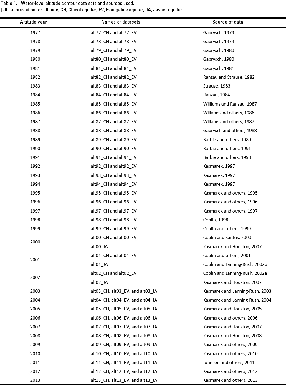
Purpose and ScopeThis report documents geospatial water-level altitude data in a geodatabase for the Chicot, Evangeline, and Jasper aquifers of the Gulf Coast aquifer system in the Houston-Galveston region, Texas. The water-level altitude data documented in this report were previously used to make annual reports depicting groundwater-level altitudes in the Chicot (1977–2013), Evangeline (1977–2013), and Jasper (2000–13) aquifers. The geospatial information in the geodatabase pertains to groundwater-level changes and groundwater altitudes in Harris, Fort Bend, and Montgomery Counties, Texas from 1977 to 2013. MethodsWater-level data were obtained by calibrated steel tape, air line, or electric water-level tape or from reported data by company well operators. The water-level altitudes used to construct the maps showing water-level altitude for the Chicot, Evangeline, and Jasper aquifers were calculated by subtracting the water-level measurement from the value of land-surface altitude for each well (point). These data were then imported into a geographic information system (GIS) by using approved and standard procedures to create contours of equal water-level altitude with intervals that vary from 25, 50, or 100 feet. Datasets and their corresponding publication are listed in table 1. Scanned images of the maps were obtained for each year of data with no existing GIS data (1977–89, 1991, 1995–99). These scanned images were then georeferenced to latitude and longitude tick marks and vector data of roads and political boundaries in the projection of Universal Transverse Mercator (UTM) Zone 15, units meters, North American Datum of 1927 (NAD27). The contours were digitized, and attribute values were added for the altitude of each contour. The completed datasets of contours were entered into the geodatabase, creating a comprehensive dataset. Existing GIS data for 1990, 1992–94, and 2000–13 were assembled and loaded into the geodatabase. The feature classes were organized into three feature datasets by principal aquifer: Chicot, Evangeline, and Jasper aquifers. To facilitate compatibility with different software platforms, all of the data compiled for the geodatabase are also provided in Environmental Systems Research Institute shapefile format.
Cited ReferencesBarbie, D.L., Coplin, L.S., and Bonnet, C.W., 1989, Approximate altitude of water levels in wells in the Chicot and Evangeline aquifers in the Houston area, Texas, spring 1989: U.S. Geological Survey Open-File Report 89–237, 2 sheets. Barbie, D.L., Coplin, L.S., and Locke, G.L., 1991, Approximate altitude of water levels in wells in the Chicot and Evangeline aquifers in the Houston area, Texas, January–February 1990: U.S. Geological Survey, Open-File Report 91–240, 2 sheets. Barbie, D.L., Kasmarek, M.C., and Campodonico, A.C., 1993, Approximate altitude of water levels in wells completed in the Chicot and Evangeline aquifers in the Houston area, Texas, January–February 1991: U.S. Geological Survey Open-File Report 93–075, 2 sheets. Coplin, L.S., 1998, Water-level altitudes 1998, water-level changes 1977–98 and 1997–98, and compaction 1973–97 in the Chicot and Evangeline aquifers, Houston-Galveston region, Texas: U.S. Geological Survey Open-File Report 98–096, 8 sheets. Coplin, L.S., Houston, N.A., and Brown, D.W., 2001, Water-level altitudes 2001, water-level changes 1977–2001 and 2000–2001, and compaction 1973–2000 in the Chicot and Evangeline aquifers, Houston-Galveston region, Texas: U.S. Geological Survey Open-File Report 01–094, 8 sheets. Coplin, L.S., and Lanning-Rush, Jennifer, 2002a, Water-level altitudes 2002 and water-level changes in the Chicot, Evangeline, and Jasper aquifers and compaction 1973–2001 in the Chicot and Evangeline aquifers, Houston-Galveston region, Texas: U.S. Geological Survey Open-File Report 02–134, 15 sheets. Coplin, L.S., and Lanning-Rush, Jennifer, 2002b, Water-level altitudes in the Jasper aquifer, greater Houston area, Texas, January–February 2001: U.S. Geological Survey Open-File Report 02–137, p. 1, 1 sheet. Coplin, L.S., and Santos, H.X., 2000, Water-level altitudes 1999, water-level changes 1977–99 and 1998–99, and compaction 1973–98 in the Chicot and Evangeline aquifers, Houston-Galveston region, Texas: U.S. Geological Survey Open-File Report 00–094, 8 sheets. Coplin, L.S., Santos, H.X., and East, J.W., 1999, Water-level altitudes 1999, water-level changes 1977–99 and 1998–99, and compaction 1973–98 in the Chicot and Evangeline aquifers; Houston-Galveston region, Texas: U.S. Geological Survey Open-File Report 99–178, 8 sheets. Gabrysch, R.K., 1979, Approximate altitude of water levels in wells in the Chicot and Evangeline aquifers in the Houston area, spring 1977 and spring 1978: U.S. Geological Survey Open-File Report 79–334, 4 sheets. Gabrysch, R.K., 1980, Approximate altitude of water levels in wells in the Chicot and Evangeline aquifers in the Houston area, Texas, spring 1979 and spring 1980: U.S. Geological Survey Open-File Report 80–579, 4 sheets. Gabrysch, R.K., 1981, Approximate altitude and water levels in wells in the Chicot and Evangeline aquifers in the Houston area, Texas, spring 1981: U.S. Geological Survey Open-File Report 81–676, 2 sheets. Gabrysch, R.K., Ranzau, C.E., Jr., and Coplin, L.S., 1988, Approximate altitude of water levels in wells in the Chicot and Evangeline aquifers in the Houston area, Texas, spring 1988: U.S. Geological Survey Open-File Report 88–334, 2 sheets. Johnson, M.R., Ramage, J.K., and Kasmarek, M.C., 2011, Water-level altitudes 2011 and water-level changes in the Chicot, Evangeline, and Jasper aquifers and compaction 1973–2010 in the Chicot and Evangeline aquifers, Houston-Galveston region, Texas: U.S. Geological Survey Scientific Investigations Map 3174, 17 p., 16 sheets. Kasmarek, M.C., 1997, Water-level altitudes in wells completed in the Chicot and Evangeline aquifers, Houston-Galveston region, Texas, January–February 1992, 1993, and 1994: U.S. Geological Survey Open-File Report 97–786, 6 sheets. Kasmarek, M.C., Coplin, L.S., and Santos, H.X., 1996, Water-level altitudes 1996, water-level changes 1977–96 and 1995–96, and compaction 1973–95 in the Chicot and Evangeline aquifers, Houston-Galveston region, Texas: U.S. Geological Survey Open-File Report 96–163, 8 sheets. Kasmarek, M.C., Coplin, L.S., and Santos, H.X., 1997, Water-level altitudes 1997, water-level changes 1977–97 and 1996–97, and compaction 1973–96 in the Chicot and Evangeline aquifers, Houston-Galveston region, Texas: U.S. Geological Survey Open-File Report 97–181, 8 sheets. Kasmarek, M.C., Coplin, L.S., and Santos, H.X., 1995, Water-level altitudes 1995, water-level changes 1977–95 and 1994–95, and compaction 1973–94 in the Chicot and Evangeline aquifers, Houston-Galveston region, Texas: U.S. Geological Survey Open-File Report 95–182, 8 sheets. Kasmarek, M.C., and Houston, N.A., 2005, Water-level altitudes 2005 and water-level changes in the Chicot, Evangeline, and Jasper aquifers and compaction 1973–2004 in the Chicot and Evangeline aquifers, Houston-Galveston region, Texas: U.S. Geological Survey Open-File Report 04–1128, 15 sheets. Kasmarek, M.C., and Houston, N.A., 2007, Water-level altitudes 2007 and water-level changes in the Chicot, Evangeline, and Jasper aquifers and compaction 1973–2006 in the Chicot and Evangeline aquifers, Houston-Galveston region, Texas: U.S. Geological Survey Scientific Investigations Map 2968, 159 p., 18 sheets. Kasmarek, M.C., and Houston, N.A., 2008, Water-level altitudes 2008 and water-level changes in the Chicot, Evangeline, and Jasper aquifers and compaction 1973–2008 in the Chicot and Evangeline aquifers, Houston-Galveston region, Texas: U.S. Geological Survey Scientific Investigations Map 2008–3031, 4 p., 17 sheets. Kasmarek, M.C., Houston, N.A., and Brown, D.W., 2006, Water-level altitudes 2006 and water-level changes in the Chicot, Evangeline, and Jasper aquifers and compaction 1973–2005 in the Chicot and Evangeline aquifers, Houston-Galveston region, Texas: U.S. Geological Survey Open-File Report 06–1079, 15 sheets. Kasmarek, M.C., Houston, N.A., and Ramage, J.K., 2009, Water-level altitudes 2009 and water-level changes in the Chicot, Evangeline, and Jasper aquifers and compaction 1973–2008 in the Chicot and Evangeline aquifers, Houston-Galveston region, Texas: U.S. Geological Survey Scientific Investigations Map 3081, 3 p., 16 sheets, 2 appendixes. Kasmarek, M.C., and Lanning-Rush, Jennifer, 2003, Water-level altitudes 2003 and water-level changes in the Chicot, Evangeline, and Jasper aquifers and compaction 1973–2002 in the Chicot and Evangeline aquifers, Houston-Galveston region, Texas: U.S. Geological Survey Open-File Report 03–109, 15 sheets. Kasmarek, M.C., and Lanning-Rush, Jennifer, 2004, Water-level altitudes 2004 and water-level changes in the Chicot, Evangeline, and Jasper aquifers and compaction 1973–2003 in the Chicot and Evangeline aquifers, Houston-Galveston region, Texas: U.S. Geological Survey Open-File Report 04–1084, 13 sheets. Kasmarek, M.C., Johnson, M.R., and Ramage, J.K., 2010, Water-level altitudes 2010 and water-level changes in the Chicot, Evangeline, and Jasper aquifers and compaction 1973–2009 in the Chicot and Evangeline aquifers, Houston-Galveston region, Texas: U.S. Geological Survey Scientific Investigations Map 3138, 17 p., 16 sheets, 1 appendix. Kasmarek, M.C., Johnson, M.R., and Ramage, J.K., 2012, Water-level altitudes 2012 and water-level changes in the Chicot, Evangeline, and Jasper aquifers and compaction 1973–2011 in the Chicot and Evangeline aquifers, Houston-Galveston region, Texas: U.S. Geological Survey Scientific Investigations Map 3230, 18 p., 16 sheets, 1 appendix. Kasmarek, M.C., Johnson, M.R., and Ramage, J.K., 2013, Water-level altitudes 2013 and water-level changes in the Chicot, Evangeline, and Jasper aquifers and compaction 1973–2012 in the Chicot and Evangeline aquifers, Houston-Galveston region, Texas: U.S. Geological Survey Scientific Investigations Map 3263, 19 p., 16 sheets. Ranzau, C.E., Jr., 1984, Approximate altitude of water levels in wells in the Chicot and Evangeline aquifers in the Houston area, Texas, spring 1984: U.S. Geological Survey Open-File Report 84–436, 2 sheets. Ranzau, C.E., Jr., and Strause, J.L., 1982, Approximate altitude of water levels in wells in the Chicot and Evangeline aquifers in the Houston area, Texas, spring 1982: U.S. Geological Survey Open-File Report 82–559, 2 sheets. Strause, J.L., 1983, Approximate altitude of water levels in wells in the Chicot and Evangeline aquifers in the Houston area, Texas, spring 1983: U.S. Geological Survey Open-File Report 83–529, 2 sheets. Williams, J.F., III, Lind, W.B., and Coplin, L.S., 1987, Approximate altitude of water levels in wells in the Chicot and Evangeline aquifers in the Houston area, Texas, spring 1987: U.S. Geological Survey Open-File Report 87–233, 2 sheets. Williams, J.F., III, and Ranzau, C.E., Jr., 1987, Ground-water withdrawals and changes in ground-water levels, ground-water quality, and land-surface subsidence in the Houston District, Texas 1980–84: U.S. Geological Survey Water Resources Investigation Report 87–4153, 4 sheets. Williams, J.F., III, Ranzau, C.E., Jr., and Coplin, L.S., 1986, Approximate altitude of water levels in wells in the Chicot and Evangeline aquifers in the Houston area, Texas, spring 1986: U.S. Geological Survey Open-File Report 86–306, 2 sheets. |
First posted September 24, 2013
For additional information contact: Part or all of this report is presented in Portable Document Format (PDF); the latest version of Adobe Reader or similar software is required to view it. Download the latest version of Adobe Reader, free of charge. |
||||||||||||||||||||||||||||||||
Johnson, M.R. and Ellis, R.H.H., 2013, Geospatial compilation of historical water-level altitudes in the Chicot and Evangeline aquifers 1977–2013 and Jasper aquifer 2000–13 in the Gulf Coast aquifer system, Houston-Galveston Region, Texas: U.S. Geological Survey Data Series 793, https://pubs.usgs.gov/ds/793/.

![]() U.S. Department of the Interior |
U.S. Geological Survey
U.S. Department of the Interior |
U.S. Geological Survey
URL: http://pubsdata.usgs.gov/pubs/ds/793/index.html
Page Contact Information: GS Pubs Web Contact
Page Last Modified: Monday, 28-Nov-2016 19:25:53 EST

