Data Series 99
A GIS Library of Multibeam Data for Massachusetts Bay and the Stellwagen Bank National Marine Sanctuary, Offshore of Boston, Massachusetts, USGS DS 99; Version 1.0
|
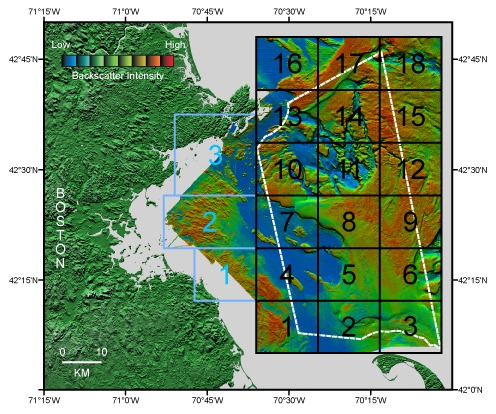
Figure 1b. Boundaries of Stellwagen Bank (1-18 in black) and western Massachusetts Bay (1-3 in blue) map series quadrangles superimposed on shaded relief topography colored by backscatter intensity. The boundary of the Stellwagen Bank National Marine Sanctuary is shown in white.
Download Adobe Reader to read PDF documents. |
Any use of trade names is for descriptive purposes only and does not imply endorsement by the U.S. Government.

![]() U.S. Department of the Interior |
U.S. Geological Survey
U.S. Department of the Interior |
U.S. Geological Survey
URL: http://pubsdata.usgs.gov/pubs/ds/99/webpages/fig1b.html
Page Contact Information: GS Pubs Web Contact
Page Last Modified: Monday, 16-Sep-2024 11:26:31 EDT