Fact Sheet 096-95
|
In 1971, the near-failure of a dam during a magnitude 6.7 earthquake forced 80,000 people to evacuate their residences. In 1994, the replacement dam survived an almost identical earthquake with little damage. Underlying this progress in designing critical structures are years of research on the powerful shaking during large earthquakes.
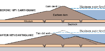
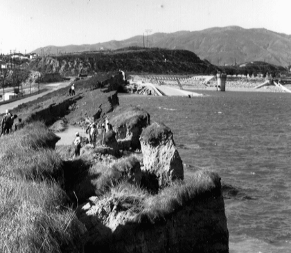
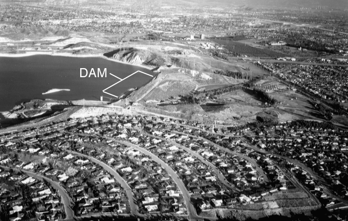 (Click on image for a full size version - 352K) (Click on image for a full size version - 352K)Perched above the densely populated San Fernando Valley, the Lower San Fernando Dam--predecessor to the Los Angeles Dam--holds a large reservoir, 1.6 miles long and as much as 130 feet deep. Severe damage of the dam during the 1971 San Fernando earthquake forced residents to evacuate homes in a 6-mile-long area down the valley. The reservoir was the terminus of the main aqueduct system for Los Angeles, which supplied 80% of the city's water. Aerial view looking northeast. Moments after the San Fernando earthquake of 1971, only a thin dirt wall stood between 80,000 people in the San Fernando Valley of southern California and 15 million tons of water poised behind a heavily damaged dam. The 142-foot-high Lower San Fernando Dam was perilously close to failure. At any moment a strong aftershock could have triggered a disaster. As it was, residents in an 11-square-mile area were forced to evacuate, while the water behind the earthen dam was lowered, a process that took 3 days. Damage from the magnitude 6.7 shock was so heavy that the dam could not be repaired to safely hold its water supply in the event of another large earthquake. A replacement dam was needed--one designed to withstand strong ground shaking associated with earthquakes expected in the area. The story of the new, safer design begins with years of research on ground motion. Throughout earthquake-prone regions of the United States, scientists record ground motion during strong earthquakes. By studying these records, scientists can estimate the severity of shaking that is likely to occur during future earthquakes. Engineers then can use these estimates to design structures better able to resist expected levels of shaking. Such cooperation among scientists and engineers is crucial to reducing fatalities, injuries, and property damage. The design of the new Los Angeles Dam is a case in point. In studying records of strong shaking from the 1971 shock and other shocks, U.S. Geological Survey (USGS) scientists realized that shaking near the epicenter of an earthquake is much stronger than had been recognized previously. Hence, they recommended the new dam be designed to withstand shaking about three times stronger than that assumed in design studies prior to USGS consultation. The recommendations were met with skepticism at first, because critical structures were being designed for lower levels of shaking at that time. Inasmuch as the new dam was to be financed with federal disaster assistance funds, the higher estimates of shaking were used in its design. 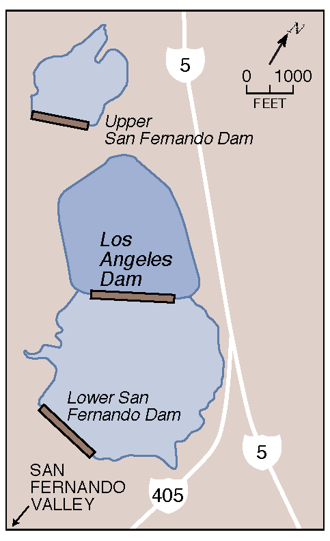 (Click on image for a full size version - 14K) (Click on image for a full size version - 14K)The Los Angeles Dam and Reservoir lie between the storm water retention basins formed by the old Lower and Upper San Fernando Dams. The new $33 million Los Angeles Dam and Reservoir was built in 1975-76 about 3,000 feet up the valley from the old Lower San Fernando Dam. However, the old dam was not dismantled. Instead, it was reconstructed--though not to meet the USGS shaking estimates--to provide a holding basin for storm water and to back up the new dam. 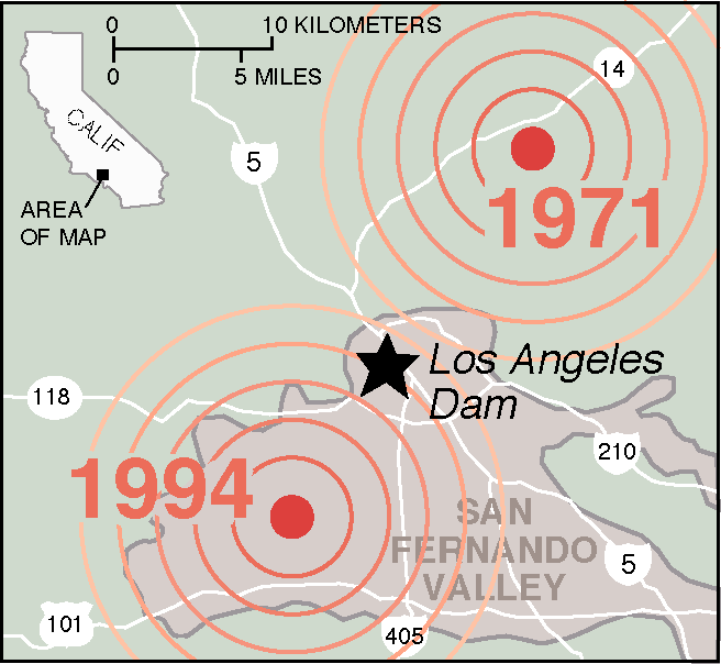 (Click on image for a full size version - 26K) (Click on image for a full size version - 26K)The Los Angeles/San Fernando damsite (star) lies between the 1971 San Fernando and 1994 Northridge earthquakes (dots). Two decades later, the 1994 Northridge earthquake put the Los Angeles Dam to the test. The Northridge earthquake was almost equal in magnitude to the previous San Fernando earthquake. Ground shaking was very strong, with amplitudes among the highest ever recorded but consistent with the USGS estimates. Yet the dam showed only minor deformation and superficial cracking. Despite the intense shaking, the crest of the dam moved only 1 inch sideways and settled only 3.5 inches. In contrast, the Lower San Fernando Dam again suffered heavily. Cracking and movement seriously damaged the upstream slope. Had the old dam been holding as much water as it had in 1971, the damage would have been far greater--at least equaling that from the 1971 earthquake.  (Click on image for a full size version - 329K) (Click on image for a full size version - 329K)The 1994 Northridge earthquake cracked the surface pavement on the upstream slope of the Los Angeles Dam. Overall, the dam, designed to withstand severe shaking, suffered very little damage. (Courtesy of Los Angeles Department of Water and Power.) Better protection of U.S. citizens from earthquake catastrophes is no accident. It comes from major advances in earthquake science, improved understanding of how structures perform during earthquakes, and enhanced construction practices. This story shows the differences in performance of two structures during nearly identical earthquakes. The Los Angeles Dam, designed to withstand severe shaking anticipated by USGS scientists, remained intact during the Northridge earthquake. In contrast, the Lower San Fernando Dam, which was built to lower shaking standards and with 1912-1915 construction methods, suffered major damage during both the 1971 and 1994 earthquakes. This success story focuses on dams. But other critical structures--such as nuclear powerplants, bridges, and hospitals--are also being built more strongly today to resist the violent shaking that is now recognized to accompany large earthquakes. |
For additional information, contact: Part or all of this report is presented in Portable Document Format (PDF). For best results viewing and printing PDF documents, it is recommended that you download the documents to your computer and open them with Adobe Reader. PDF documents opened from your browser may not display or print as intended. Download the latest version of Adobe Reader, free of charge. More information about viewing, downloading, and printing report files can be found here. |
Page, R.A., Boore, D.M., and Yerkes, R.F., 1995, The Los Angeles Dam story: U.S. Geological Survey Fact Sheet 096–95. (Available at https://pubs.usgs.gov/fs/1995/0096/.)

![]() U.S. Department of the Interior |
U.S. Geological Survey
U.S. Department of the Interior |
U.S. Geological Survey
URL: http://pubsdata.usgs.gov/pubs/fs/1995/0096/index.html
Page Contact Information: GS Pubs Web Contact
Page Last Modified: Wednesday, 10-May-2017 19:43:25 EDT