Fact Sheet 166-95
|
Almost 75 percent of Utah's population lives near the Wasatch Fault. Earth
scientists have shown that this fault has repeatedly experienced strong
earthquakes of magnitude 7 or larger and will continue to do so in the
future. Efforts to increase public awareness of earthquake hazards in Utah
have resulted in residents and community leaders taking actions that will
save lives and reduce damage in future earthquakes.
When the first trail-weary Mormon settlers arrived in the Salt Lake area of Utah in 1847, they proclaimed it to be "the place." They did not know, however, that the spectacular landscapes of the Wasatch Range and adjacent valleys had been largely shaped by numerous powerful earthquakes. The people of Utah were first publicly informed of the danger that threatens them in 1883 in the Salt Lake Tribune, when G.K. Gilbert of the U.S. Geological Survey (USGS) warned that future violent earthquakes on the Wasatch Fault could be disastrous for the growing towns the settlers had built. 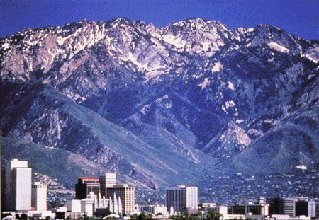 (Click on image for a full size version - 117K) (Click on image for a full size version - 117K)The Wasatch Fault cuts along the base of the abrupt mountain front rising behind the buildings of downtown Salt Lake City. Movement on this fault has uplifted the Wasatch Range to form a spectacular backdrop for Utah's three largest cities. (Courtesy of the Salt Lake Convention and Visitors Bureau.) Although residents of Utah have so far been spared the disaster that Gilbert foresaw more than a century ago, several earthquakes of magnitude 7 or larger have struck other areas between the Rocky Mountains and the Sierra Nevada in that time. The most recent of these occurred in 1983 near Borah Peak, Idaho, and once again reminded the people of Utah of the potential for catastrophic earthquakes in their state. At about the same time, the USGS Earthquake Hazards Reduction Program launched a full-scale study of this earthquake threat, and the residents of Utah began to increase their planning for a catastrophic earthquake on the Wasatch Fault. 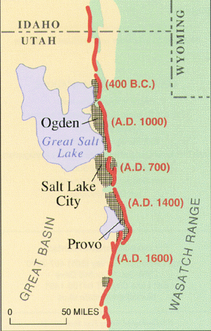 (Click on image for a full size version - 82K) (Click on image for a full size version - 82K)Earthquakes on the Wasatch Fault threaten the urban areas of Utah (hachured). About 75% of the State's 2 million people live within 15 miles of one of the fault's several segments (red). Dates indicate approximately when the most recent strong (magnitude greater than 6.5) earthquake occurred on a fault segment. By the late 1980's, scientists from the USGS, the Utah Geological Survey, the University of Utah, and other cooperating institutions had learned that:
To ensure that this new knowledge was effectively used to reduce earthquake losses, the USGS supported geologists to work with the planning departments of four Utah counties. These geologists prepared maps that show where ground failures (fracturing, slumping, and sliding) from Wasatch Fault earthquakes are expected to be most severe. Such hazard maps assist public officials in evaluating requests for construction approval and urban planners in recommending suitable land-use practices.  (Click on image for a full size version - 99K) (Click on image for a full size version - 99K)The historic Salt Lake City and County Building has been made safer from earthquakes by a state-of-the-art engineering technique called base isolation. Rubber pads used in the technique have been installed beneath this 101-year-old unreinforced masonry structure to cushion it from earthquake shaking. (Courtesy of the Salt Lake Convention and Visitors Bureau.) Using the information provided by scientists, Utah residents and their representatives have embarked on several courses of action to prepare for earthquakes. They have:
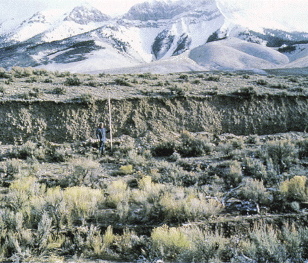 (Click on image for a full size version - 167K) (Click on image for a full size version - 167K)More than 6 feet was added to this fault scarp by vertical movement in the 1983 Borah Peak, Idaho, earthquake (magnitude 7.3). Because the region affected was sparsely populated, the earthquake caused only two deaths and about $10 million of damage. An earthquake of similar magnitude on the Wasatch Fault in Utah would affect heavily populated urban areas and could have much more severe consequences. Although no powerful earthquake has occurred on the Wasatch Fault for the past 150 years, future such events are certain. In the past decade, the people of Utah have become more aware of the threat of a catastrophic earthquake. Strong bonds between residents, their church communities, and public agencies have created an effective network for disaster preparation unequaled in the United States. Taking action today reduces the loss of life and property in future earthquakes. The Utah experience exemplifies what can be achieved in earthquake-prone regions of the United States through the cooperation of scientists and engineers, government, and the local community. |
For additional information, contact: Part or all of this report is presented in Portable Document Format (PDF). For best results viewing and printing PDF documents, it is recommended that you download the documents to your computer and open them with Adobe Reader. PDF documents opened from your browser may not display or print as intended. Download the latest version of Adobe Reader, free of charge. More information about viewing, downloading, and printing report files can be found here. |
Machette, M.N., and Brown, W.M., 1995, Utah braces for the future: U.S. Geological Survey Fact Sheet 166–95, 2 p. (Available at https://pubs.usgs.gov/fs/1995/0166/.)

![]() U.S. Department of the Interior |
U.S. Geological Survey
U.S. Department of the Interior |
U.S. Geological Survey
URL: http://pubsdata.usgs.gov/pubs/fs/1995/0166/index.html
Page Contact Information: GS Pubs Web Contact
Page Last Modified: Wednesday, 10-May-2017 19:08:11 EDT
