Fact Sheet 167-95
|
In this century, major earthquakes in the United States have damaged or
destroyed numerous buildings, bridges, and other structures. By monitoring
how structures respond to earthquakes and applying the knowledge gained,
scientists and engineers are improving the ability of structures to survive
major earthquakes. Many lives and millions of dollars have already been saved
by this ongoing research.
 (Click on image for a full size version - 216K) (Click on image for a full size version - 216K)The Transamerica Pyramid in San Francisco, built to withstand earthquakes, swayed more than 1 foot but was not damaged in the 1989 Loma Prieta, California, earthquake. On October 17, 1989, the magnitude 7.1 Loma Prieta earthquake struck the Santa Cruz Mountains in central California. Sixty miles away, in downtown San Francisco, the occupants of the Transamerica Pyramid were unnerved as the 49-story office building shook for more than a minute. U.S. Geological Survey (USGS) instruments, installed years earlier, showed that the top floor swayed more than 1 foot from side to side. However, no one was seriously injured, and the Transamerica Pyramid was not damaged. This famous San Francisco landmark had been designed to withstand even greater earthquake stresses, and that design worked as planned during the earthquake. 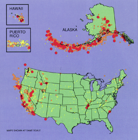 (Click on image for a full size version - 128K) (Click on image for a full size version - 128K)Earthquakes are a widespread hazard in the United States. Colors show magnitudes of historical earthquakes: red, 7 or greater; orange, 5.5 to 7; yellow, 4.5 to 5.5. The U.S. Geological Survey operates instruments in many structures in the seismically active areas shown. These instruments measure how structures respond to earthquake shaking. Designing and building large structures is always a challenge, and that challenge is compounded when they are built in earthquake-prone areas. More than 60 deaths and about $ 6 billion in property damage resulted from the Loma Prieta earthquake. As earth scientists learn more about ground motion during earthquakes and structural engineers use this information to design stronger buildings, such loss of life and property can be reduced. To design structures that can withstand earthquakes, engineers must understand the stresses caused by shaking. To this end, scientists and engineers place instruments in structures and nearby on the ground to measure how the structures respond during an earthquake to the motion of the ground beneath. Every time a strong earthquake occurs, the new information gathered enables engineers to refine and improve structural designs and building codes. In 1984 the magnitude 6.2 Morgan Hill, California, earthquake shook the West Valley College campus, 20 miles away. Instruments in the college gymnasium showed that its roof was so flexible that in a stronger or closer earthquake the building might be severely damaged, threatening the safety of occupants. At that time, these flexible roof designs were permitted by the Uniform Building Code (a set of standards used in many states). Many industrial facilities nationwide were built with such roofs. 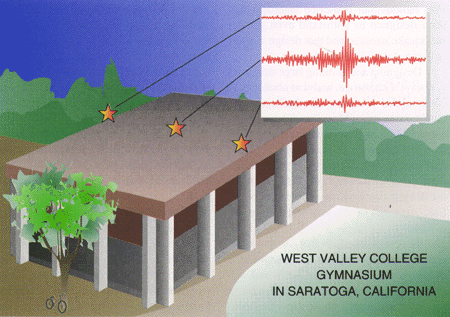 (Click on image for a full size version - 82K) (Click on image for a full size version - 82K)Seismic records (upper right) obtained during the 1984 Morgan Hill, California, earthquake led to an improvement in the Uniform Building Code (a set of standards used in many states). The center of the gym roof shook sideways three to four times as much as the edges. The Code has since been revised to reduce the flexibility of such large-span roof systems and thereby improve their seismic resistance. Building codes provide the first line of defense against future earthquake damage and help to ensure public safety. Records of building response to earthquakes, especially those from structures that failed or were damaged, have led to many revisions and improvements in building codes. In 1991, as a direct result of what was learned about the West Valley College gymnasium roof, the Uniform Building Code was revised. It now recommends that such roofs be made less flexible and therefore better able to withstand large nearby earthquakes. Earth scientists began recording earthquakes about 1880, but it was not until the 1940's that instruments were installed in buildings to measure their response to earthquakes. The number of instruments installed in strucures increased in the 1950's and 1960's. The first abundant data on the response of structures came from the devastating 1971 San Fernando, California, earthquake, which yielded several dozen records. These records were primitive by today's standards. The first records from instruments sophisticated enough to measure twisting of a building were obtained during the 1979 Imperial Valley, California, earthquake. Today there are instruments installed in hospitals, bridges, dams, aqueducts, and other structures throughout the earthquake-prone areas of the United States, including Illinois, South Carolina, New York, Tennessee, Idaho, California, Washington, Alaska, and Hawaii. Both the California Division of Mines and Geology (CDMG) and the USGS operate instruments in California. The USGS also operates instruments in the other seismically active regions of the nation.   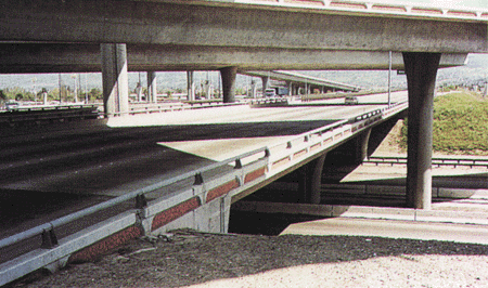 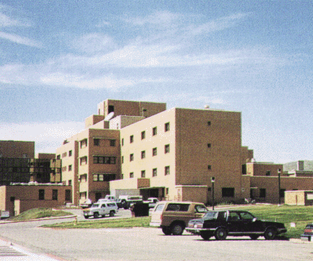 (Click on images for full size versions - 192K, 238K, 98K, 114K) (Click on images for full size versions - 192K, 238K, 98K, 114K)USGS scientists have installed instruments in a variety of structures across the United States to monitor their behavior during earthquakes. Examples shown include a dam, a bridge supporting a large aqueduct, a highway overpass, and a Veterans hospital. The majority of deaths and injuries from earthquakes are caused by the damage or collapse of buildings and other structures. These losses can be reduced through documenting and understanding how structures respond to earthquakes. Gaining such knowledge requires a long-term commitment because large devastating earthquakes occur at irregular and often long intervals. Recording instruments must be in place and waiting, ready to capture the response to the next temblor whenever it occurs. The new information acquired by these instruments can then be used to better design earthquake-resistant structures. In this way, earth scientists and engineers help reduce loss of life and property in future earthquakes. |
First posted April 13, 2011 Revised June 15, 2012 For additional information, contact: Part or all of this report is presented in Portable Document Format (PDF). For best results viewing and printing PDF documents, it is recommended that you download the documents to your computer and open them with Adobe Reader. PDF documents opened from your browser may not display or print as intended. Download the latest version of Adobe Reader, free of charge. More information about viewing, downloading, and printing report files can be found here. |
Ҫelebi, M., Page, R.A., and Seekins, Linda, 1995, Building safer structures (Revised June 1998): U.S. Geological Survey Fact Sheet 167–95. (Available at https://pubs.usgs.gov/fs/1995/0167/.)

![]() U.S. Department of the Interior |
U.S. Geological Survey
U.S. Department of the Interior |
U.S. Geological Survey
URL: http://pubsdata.usgs.gov/pubs/fs/1995/0167/index.html
Page Contact Information: GS Pubs Web Contact
Page Last Modified: Wednesday, 10-May-2017 20:09:28 EDT
