Fact Sheet 224-95
|
When a powerful earthquake strikes an urban region, damage concentrates not
only near the quake's source. Damage can also occur many miles from the
source in areas of soft ground. In recent years, scientists have developed
ways to identify and map these areas of high seismic hazard. This advance has
spurred pioneering legislation to reduce earthquake losses in areas of
greatest hazard.
Television cameras broadcasting the start of the 1989 World Series instead recorded the urban devastation from a major earthquake striking Northern California. Four hours after the earthquake struck, homes in San Francisco's prosperous Marina District still burned out of control from fires started by broken gas lines; the shock severely damaged or destroyed 70 residential buildings in the district. Across San Francisco Bay in Oakland, the collapse of the double-decker Cypress freeway structure trapped more than 160 people, 42 of whom died. Both of these grim spectacles from the magnitude 7.1 Loma Prieta, California, earthquake occurred more than 50 miles from the temblor's source in areas underlain by soft soil (loose sediment, uncompacted fill, and mud). In contrast, structures built on rock and firm soil, which underlie most of San Francisco and Oakland, were largely unscathed. Near the earthquake's epicenter, however, shaking was violent enough to cause considerable damage even in areas underlain by rock and firm soil.  (Click on image for a full size version - 101K) (Click on image for a full size version - 101K)Buildings constructed on uncompacted fills and soft soils are especially vulnerable to earthquake shaking damage. In this photo, taken four hours after the 1989 Loma Prieta, California, earthquake had struck, homes in San Francisco's Marina District still burn out of control from fires started by broken gas lines. The district was built on artificial fill that included rubble from the great quake of 1906. Scientists can identify areas where such shaking damage is likely to be especially severe. (Photo by Martin Klimek, Marin Independent Journal.) This localization of severe shaking and damage was no surprise. It had been noted in previous San Francisco-area earthquakes, as early as 1868. Only after the devastating 1964 magnitude 9.2 Alaska earthquake, however, did the nation direct much attention toward understanding and mapping earthquake hazards. In the late 1960's, the U.S. Geological Survey (USGS) launched a program to develop methods for identifying and mapping areas of potential earthquake hazard. An early product of this program was a series of maps showing the locations of active segments of the San Andreas Fault in California. These maps demonstrated the feasibility of identifying faults that might rupture the ground surface in future earthquakes. This capability lead to new strategies to reduce losses from such ruptures. In 1972, the California Legislature passed a landmark law requiring the identification of seismic-hazard zones along faults. In these zones, special geologic studies are required before structures can be built for human occupancy. This law has successfully prevented homes, schools, and offices from being built across active faults. The major cause of earthquake damage, however, is strong ground shaking, not the rupture of the ground surface by faulting. Strong shaking damages or collapses weak structures over wide areas. It also triggers ground failures (fracturing, sliding, and slumping), which in turn damage or destroy structures and disrupt utility and transportation systems. In the mid-1970's, the USGS published an innovative map of the ground-shaking hazard for part of the San Francisco Bay region. This map was used by local and regional government bodies to develop seismic safety policies. The map predicted that shaking on soft ground would be several times as intense as that on nearby rock. Some engineers and scientists were skeptical of these predictions, but records of strong shaking and patterns of damage in the 1989 Loma Prieta earthquake verified the predictions. The map had correctly showed the Marina District and the area of the Cypress freeway structure as being subject to violent shaking during earthquakes. 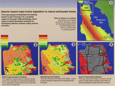 (Click on image for a full size version - 83K) (Click on image for a full size version - 83K)Seismic hazard maps further legislation to reduce earthquake losses: This map sequence illustrates the shaking hazard in San Francisco for a possible repeat of the great 1906 earthquake. Such maps provide information essential for developing effective seismic safety policies and laws. 1-Effect of distance on shaking: Expected ground shaking on bedrock decreases rapidly with increasing distance from the San Andreas Fault, from very violent (red) to moderate (green). 2-Effect of ground type on shaking: The capability of ground type to amplify shaking varies from very high for mud and uncompacted fill, to moderate for sandy soil, to low for soft rock, and to none for hard rock. 3-Expected ground shaking: This map combines information from Maps 1 and 2 to show expected shaking levels throughout San Francisco. 4-Areas of most intense shaking: This map, derived from Map 3, shows in red the areas of most intense shaking where efforts to reduce earthquake losses should be focused. Faced with the disastrous losses from the Loma Prieta shock, the California Legislature realized that stronger measures were needed to combat earthquake hazards. In 1990, the Legislature passed the California Seismic Hazards Mapping Act to assist cities and counties in protecting public health and safety against such hazards. This law requires the State Geologist to make maps of seismic hazard zones, identifying areas prone to violent shaking and ground failure. It also requires that evaluation of these potential hazards precede approval of construction projects within defined hazard zones and that buyers of real estate be notified when the property lies within such a zone. This act builds on the success of both the 1972 law and the early maps of predicted ground shaking. 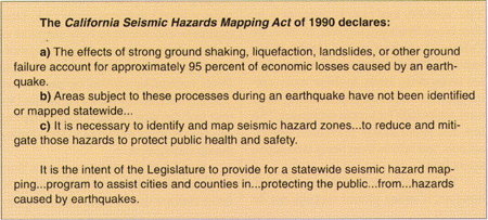 (Click on image for a full size version - 72K) (Click on image for a full size version - 72K)Experience in many states reveals that seismic hazard maps serve diverse audiences. Users of these maps include buyers and owners of real estate, geotechnical consultants and engineers, financial institutions, utility and transportation companies, emergency managers, and government planners. Mapping seismic hazards is especially important in urban areas of earthquake-prone regions of the United States. Such areas have large populations and huge investments in structures and lifelines that are at risk from earthquakes. Potential losses from future urban earthquakes are staggering. For example, a repeat of the 1886 Charleston, South Carolina, earthquake today would cause an estimated 2,000 fatalities and $5 billion of damage. In the central Mississippi Valley region, projected losses from a repeat of an 1811 earthquake are 6,000 lives and $50 billion of damage. Crucial to reducing these potential losses is sound geologic knowledge leading to effective seismic safety policies and legislation. |
First posted 1995 Revised June 15, 2012 For additional information, contact: Part or all of this report is presented in Portable Document Format (PDF). For best results viewing and printing PDF documents, it is recommended that you download the documents to your computer and open them with Adobe Reader. PDF documents opened from your browser may not display or print as intended. Download the latest version of Adobe Reader, free of charge. More information about viewing, downloading, and printing report files can be found here. |
Borcherdt, R.D., Brown, R.B., Page, R.A., Wentworth, C.M., and Hendley J.W., II, 1995, Seismic maps foster landmark legislation: U.S. Geological Survey Fact Sheet 224–95, 2 p. (Available at https://pubs.usgs.gov/fs/1995/0224/.)

![]() U.S. Department of the Interior |
U.S. Geological Survey
U.S. Department of the Interior |
U.S. Geological Survey
URL: http://pubsdata.usgs.gov/pubs/fs/1995/0224/index.html
Page Contact Information: GS Pubs Web Contact
Page Last Modified: Wednesday, 10-May-2017 19:29:00 EDT
