
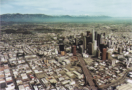
The striking landscapes and hospitable climate of Southern California are home to more than 20 million people and vital elements of the Nation's economy. Unfortunately, the region is also laced with many active faults that can produce strong earthquakes. The best-known example is the San Andreas Fault, which runs almost the entire length of California and generates shocks as large as magnitude 8. In Southern California the last such great earthquake was in 1857. Much more frequent are smaller temblors like the 1971 San Fernando and 1994 Northridge earthquakes; both of these magnitude 6.7 quakes were very damaging.
 (Click on image for a full size version - 131K)
For residents of Southern California, earthquakes are an unavoidable part of life. Ask someone there about the pros and cons of living in the area, and invariably the disadvantages will include earthquakes. Nonetheless, Southern Californians have learned, through experience, that it is possible to live with some measure of safety in their earthquake-prone land.

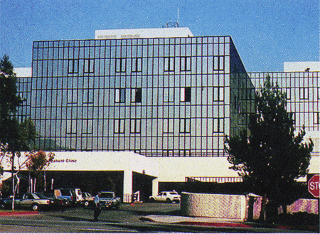
(Click on images for full size versions - 108K, 121K)
Improved construction standards help buildings survive earthquakes. The Olive
View Hospital in Sylmar, California, was built in 1964 to meet the earthquake
provisions of building codes in place at that time. It partially collapsed
(left) in the devastating 1971 magnitude 6.7 San Fernando earthquake. Rebuilt
to stricter design and construction standards, the hospital was again
subjected to strong shaking in the 1994 Northridge earthquake. This quake, of
the same magnitude as the 1971 quake, caused no serious damage to the rebuilt
hospital (right).
Advances in engineering and earth science help Southern Californians better prepare for future temblors. New knowledge is applied to make both old and new structures safer in earthquakes. For example, analyses of damage in past earthquakes have prompted increasingly strict standards of design and construction. The benefits of more stringent building codes were seen in the Northridge quake; structures built to recent standards generally survived with little or no damage.
Older structures that have not been strengthened to meet recent seismic design codes, in particular unreinforced masonry buildings, are the most serious safety threat in earthquakes. Recognizing this danger, the City of Los Angeles began strengthening such buildings in the early 1980's. More than 6,000 had been reinforced when the 1994 Northridge shock hit. This one program undoubtedly prevented substantial loss of life and property in that temblor.
Further efforts to reduce the risk from earthquakes in an effective and practical way requires knowledge of the level of hazard in different areas. Future earthquakes are most likely to originate where energy along a fault has built up and has not yet been released in earthquakes. Studies supported by the National Earthquake Hazards Reduction Program enable scientists to evaluate the hazard level in different areas. In Southern California, scientists estimate that the probability of a magnitude 7 or greater earthquake by the year 2024 is as high as 80 to 90%.
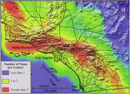 (Click on image for a full size version - 115K)
How the threat from earthquake ground shaking varies across Southern California is shown on a new hazard map. This map, derived from decades of work by scientists in government, universities, and private industry, shows how often any location in the region is likely to experience earthquake shaking strong enough to inflict damage. The map was prepared by the Southern California Earthquake Center, a consortium funded largely by the U.S. Geological Survey and the National Science Foundation.
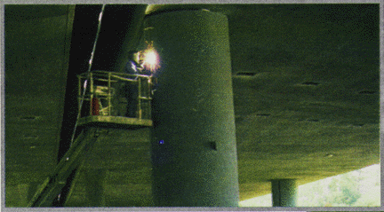
Such maps of expected earthquake shaking help those responsible for public safety decide where actions to reduce future earthquake losses will be most effective. For example, these maps help the California Department of Transportation (Caltrans) decide which bridges should have priority for seismic strengthening. In the years between the 1971 San Fernando and the 1994 Northridge earthquakes, Caltrans reinforced more than 100 freeway overpasses in Los Angeles and Ventura Counties. Not one of these reinforced freeway overpasses failed in the 1994 shock, whereas seven unreinforced spans in the same area collapsed. These positive results have led Caltrans to step up the pace of this program-they are convinced that every dollar spent on seismic reinforcements will save many dollars by averting future losses. Another 700 bridges and overpasses in the two counties are scheduled for strengthening by the end of 1997.
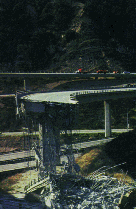
 (Click on images for full size versions - 79K, 66K)
As well as guiding such seismic strengthening projects, earthquake hazard maps are used by engineers in designing earthquake-resistant structures, by planners in establishing wise land-use policies, by emergency managers for drawing disaster response plans, and by insurance experts for analyzing risks and loss exposure. Furthermore, the data underlying the maps are used by engineers to assess specific hazards at particular sites and develop safe design solutions.
Earthquakes may be inevitable, but earthquake disasters are not. Scientists and engineers are continuously working to understand earthquake hazards better. This improved knowledge helps guide steps to reduce future earthquake losses. The result is that residents of Southern California and other seismically active areas of the United States can live with greater peace of mind in earthquake country.
Kenneth W. Hudnut, James J. Mori, William H. Prescott, and Peter H. Stauffer
COOPERATING AGENCIES, COMPANIES, AND INSTITUTIONS
California Department of Transportation
California Division of Mines and Geology
California Institute of Technology
City and County of Los Angeles
Columbia University
National Science Foundation
Southern California Earthquake Center
University of California, Los Angeles
University of California, Santa Barbara
University of California, San Diego
University of Southern California
For more information contact:
Earthquake Information Hotline (650) 329-4085
U.S. Geological Survey, MS 977
345 Middlefield Road, Menlo Park, CA 94025
USGS Menlo Park Earthquakes Home Page
U.S. Geological Survey Fact Sheet-225-95, March 1995
URL of this page: https://pubs.usgs.gov/fs/1995/fs225-95/
Web created by Will Prescott, April 9, 1996 Modified by Miie Diggles May 9, 2005
