| Latest Quake Info | General Quake Info | Hazards & Preparedness | Earthquake Research | Special Features | Additional Resources |

Earthquake forecasts declare that a temblor has a certain probability of occurring within a given time, not that one will definitely strike. In this way they are similar to weather forecasts. Scientists are able to make earthquake forecasts because quakes tend to occur in clusters that strike the same area within a limited time period. The largest quake in a cluster is called the mainshock, those before it are called foreshocks, and those after it are called aftershocks.
 (Click on image for a full size version - 120K)
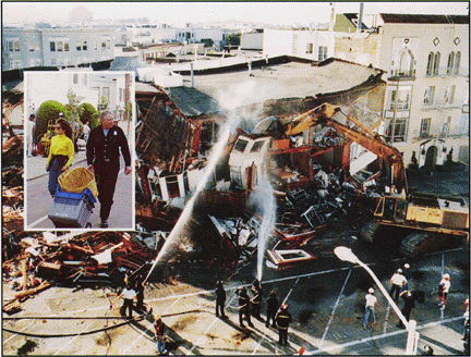
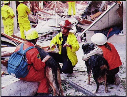
In any cluster, most quakes are aftershocks. Most aftershocks are too small to cause damage, but following a large mainshock one or more may be powerful. Such strong aftershocks can cause additional damage and casualties in areas already devastated by a mainshock and also threaten the lives of rescuers searching for the injured. In the first few weeks after the 1994 magnitude 6.7 Northridge, California, earthquake, more than 3,000 aftershocks occurred. One magnitude 5.2 aftershock caused $7 million in damage just to electric utility equipment in the Los Angeles area.
The U.S. Geological Survey (USGS) first began forecasting aftershocks following the 1989 magnitude 7.1 Loma Prieta, California, earthquake. By studying previous earthquakes, scientists had detected patterns in the way aftershocks decrease in number and magnitude with time. With such knowledge, scientists can estimate the daily odds for the occurrence of damaging aftershocks following large California temblors. These forecasts are relayed directly to the California Office of Emergency Services (OES) and to the public.
Aftershock forecasts assist government, industry, and emergency response teams in deciding when it is safe to demolish, repair, or allow people to use damaged structures. In the aftermath of the 1989 Loma Prieta earthquake, the "probability of aftershocks given by the USGS was one of the factors ... used in deciding how many firefighters to keep on duty" (Greg Abell, Battalion Chief, San Francisco Fire Department).
 (Click on image for a full size version - 120K)
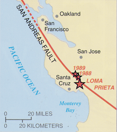
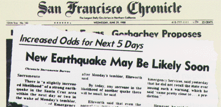
Some large earthquakes are preceded by foreshocks. Knowledge of past earthquake patterns allows scientists to estimate the odds that an earthquake striking today is a foreshock and will soon be followed by a larger mainshock in the same area. These odds depend on the earthquake's magnitude and the seismic history of the fault on which it occurred. When a moderate earthquake hits California, scientists immediately estimate the probability that a damaging mainshock will follow. If the threat is significant, a warning is issued.
This warning process was put into action in June 1988 when a magnitude 5.1 shock--one of the largest in the San Francisco Bay region since the great 1906 earthquake--struck 60 miles south of San Francisco. Alerted by the USGS that there was a 1 in 20 chance of a larger earthquake in the next 5 days, the California OES issued an advisory to warn the public. (The usual daily odds of a large quake in the Bay region are 1 in 15,000.) The warning period passed without further activity. In August 1989, another earthquake hit the same area and a similar advisory was issued. Again nothing happened in the specified warning period. However, 69 days later, the area was rocked by the magnitude 7.1 Loma Prieta earthquake, which killed 63 people and caused $6 billion damage in the San Francisco Bay region.

Although these warnings did not pinpoint the actual date of the Loma Prieta mainshock, local governments still found them useful. For example, in the city of Oakland during the August 1989 advisory "all ... departments ran drills to prepare for an imminent earthquake. This made a tremendous difference in the city's response when the [Loma Prieta] earthquake struck" (Henry Renteria, Emergency Services Manager, Oakland). Emergency managers and the public use earthquake advisories for making the swift and often complex decisions that are essential to reduce the risk posed by a forecast shock. Good communication and understanding between scientists, emergency managers, and the public are essential if advisories are to be effective. Developing such communication and understanding is a goal of the USGS Parkfield (California) Earthquake Prediction Experiment.
The town of Parkfield, population 34, was chosen as the site of this innovative experiment because six magnitude 6 earthquakes have struck in its vicinity since 1857. Some of these quakes were preceded by foreshocks and possibly by other precursors. Because the time between a precursor and a mainshock may be short, earthquake warnings must be communicated rapidly. To accomplish this, a plan was developed specifying when and how warnings are to be issued in response to possible precursors to earthquakes in the Parkfield area. This plan was activated in 1992 and again in 1993 by possible foreshocks; state and county officials conducted rapid, well-planned responses.
The lessons learned from the Parkfield experiment have already enabled earth scientists and emergency response officials to build a framework within which they communicate rapidly and effectively. Based on this experience, similar alert plans have been devised for geologic hazards in other areas of the United States. With the development of modern seismic monitoring networks and the knowledge gained from past shocks, earthquake forecasts and warnings are now a reality. Continued effective communication of these forecasts to the public will help reduce loss of life and property in future earthquakes.
Andrew Michael, Paul Reasenberg, Peter H. Stauffer, and James W. Hendley II
COOPERATING ORGANIZATIONS
California Office of Emergency Services
California Division of Mines and Geology
For more information contact:
Earthquake Information Hotline (650) 329-4085
U.S. Geological Survey, MS 977
345 Middlefield Road, Menlo Park, CA 94025
USGS Menlo Park Earthquakes Home Page
U.S. Geological Survey Fact Sheet-242-95, March 1995
Web page by Will Prescott - 1996 April 3. Last revision by Michael Diggles January 5, 2007
