U.S. Department of the Interior
U.S. Geological Survey
FS-175-96
Internal Surface Water Flows
Introduction |
Importance
of Flow and Water-Quality Information for Ecosystem Management |
Project Goal |
Acoustic
Techniques for Flow Measurement |
Data Collection |
Product Plans |
Project Schedule
The South Florida Ecosystem Restoration Program
is an intergovernmental effort to reestablish and maintain the ecosystem
of south Florida. One element of the restoration effort is the development
of a firm scientific basis for resource decision making.The U.S. Geological
Survey (USGS) provides scientitic information as part of the South Florida
Ecosystem Restoration Program. The USGS began its own project, called the
South Florida Ecosystem Project in fiscal year 1995 for the purpose of
gathering hydrologic, cartographic, and geologic data that relate to the
mainland of south Florida, Florida Bay, and the Florida Keys and Reef
ecosystems.
Historical changes in water-management practices
to accommodate a large and rapidly growing urban population along the Atlantic
coast, as well as intensive agricultural activities, have resulted in a
highly managed hydrologic system with canals, levees, and pumping stations.
These structures have altered the hydology of the Everglades ecosystem
on both coastal and interior lands. Surface-water flows in a direction
south of Lake Okeechobee have been regulated by an extensive canal network,
begun in the 1940's, to provide for drainage, flood control, saltwater
intrusion control, agricultural requirements, and various environmental
needs. Much of the development and subsequent monitoring of canal and river
discharge south of Lake Okeechobee has traditionally emphasized the eastern
coastal areas of Florida. Recently, more emphasis has been placed on providing
a more accurate water budget for internal canal flows.
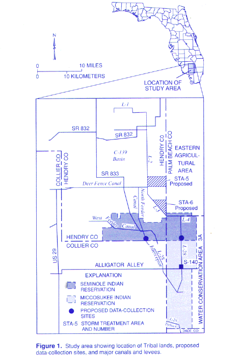
As part of the South Florida Ecosystem Restoration
Program, the U.S Army Corps of Engineers and the South Florida Water Management
District (SFWMD) propose modified water deliveries to Indian Tribal lands.
Big Cypress National Preserve, and other noncoastal areas of south Florida.
The proposed modified water deliveries are designed to provide flood protection
and water delivery benefits to agricultural lands as well as partial restoration
of historic ecosystem conditions within both Seminole and Miccosukee Tribal
lands ( fig. 1 ). The effects that these proposed
modified water- delivery changes will have on Indian Tribal lands can only
be deternined if internal flows and associated water quality are accurately
known. The Everglades Construction Project, which developed as a result
of the South Florida Ecosystem Restoration Program, required diversion
of the C-139 Basin surface water to storm treatment area 5 ( fig.
1 , STA-5) and will cause a change in the volume and quality of the
water subject to Tribal entitlement.
The objective of this project is to evaluate approaches
for quantifying freshwater flows to and from Native American lands and
to provide various hydrologic data to support other Federal and State hydrologic
investigations. The implementation and development of strategically locating
streamflow and water-quality gaging sites will provide information for
determining future surface water flow requirements. Subsequent studies
based on accurate flow calibrations generated by these sites will be used
for computation of nutrient loadings in the canal system. Providing continuous-flow
data at selected impact points for internal basins will complement the
eastern flow canal discharge network and allow for suface-water releases
that are more accurately timed. The accounting of all significant hydrologic
inflows and ouflows to the Everglades ecosystem of the south Florida mainland
is a key element of the South Florida Ecosystem Program.
Before the development of currently available acoustic
instruments, it was very difficult to gage flows in a highly regulated
network of canals and streams. Standard methods for field data collection
and flow computations are impractical and inaccurate because of the low
velocities, flow reversal, and the presence of submerged aquatic plants.
With the state-of-the-art acoustic instumentation, such as the acoustic
velocity meter (AVM) and the Acoustic Doppler Current Profiler (ADCP),
it is possible to more accurately gage flows in this type of environment
because of the ability of AVM's and ADCP's to quickly measure low or radily
changing water velocities. AVM systems have proven to be accurate instruments
in the measurement of water velocities along a horizontal path across a
stream and can be permanently installed to collect continuous velocity
data, which, along with water-level data, are used to produce continuous
records of discharge. ADCP instruments can be used to measure water velocities
in three dimensions. These measurements can then be used to calculate the
total flow through a stream section at a given time. The ADCP uses the
Doppler shift from four acoustic beams transmitted downward (at set angles)
to measure the velocity of water, depth, and distance traveled across the
stream transect. Field measurements made with the ADCP's can be used to
develop relations between continuous recording gages collecting AVM velocities
and discharge at gaged sites.
Two new continuous water-level, AVM discharge, and
water-quality sites ( fig. 1 ) will be added in
conjunction with the larger plan to monitor internal surface-water flows.
Sites will be located at critical water-delivery points for which information
is lacking on both the L-28 and L-28 interceptor canals
(fig. 1). In addition to the SFWMD's
existing network, a joint effort between
the USGS and SFWMD is planned to be initiated to construct, calibrate,
monitor, quality assure, and produce daily water-level, discharge, and
nutrient loading tabulations. The SFWMD will provide assistance by installing
flow-weighted samplers at USGS AVM gaging sites for nutrient analysis (nitrogen
and phosphorus) in conjunction with streamflow monitoring.
Dialy water-level discharge, and nutrient loading
computations will be made. Plans are to publish all these data in
the USGS report "Water Resources for South Florida: Volume 2A" on a yearly
basis, starting in the second year of the 4-1/2 year project (5/1/1996
to 9/30/2000).
Tentative dates and the planned project activities are summarized below:
| 9/96: | Automated remote site data stream command program language development by the USGS to facilitate SFWMD telemetry. |
| 10/96: | Construction and Instrumentation of sites by the USGS with telemetry programming assistance from the SFWMD. The USGS begins calibration. |
| 4/98: | Daily value streamflow and stage computations and statistics completed for the 1997 fiscal year and published in the USGS publication "Water Resources Data for South Florida: Volume 2A." Nutrient loading computations to be made available in a yet to be determined format. |
Fact Sheet 175-96
AUTHOR: M.H. Murray
![]() Click here for a PDF version of this fact sheet (available from the Water Resources of Florida website). PDF files require the Free Adobe Acrobat Reader ® to be read.
Click here for a PDF version of this fact sheet (available from the Water Resources of Florida website). PDF files require the Free Adobe Acrobat Reader ® to be read.
For more information contact:
Related information:
Mitchell H. Murray
U.S. Geological Survey
9100 N.W. 36th Street
Suite 107
Miami, FL 33178
(305) 526 - 2895 or mmurray@usgs.gov
SOFIA Project: Internal Surface Water Flows
| Disclaimer | Privacy Statement | Accessibility |
U.S. Department of the Interior, U.S. Geological Survey
This page is: http://sofia.usgs.gov/publications/fs/175-96/print.html
Comments and suggestions? Contact: Heather Henkel - Webmaster
Last updated: 04 September, 2013 @ 02:03 PM(TJE)