| U.S. Department of the Interior US Geological Survey Fact Sheet 193-96 |
Study Design and Preliminary Data Analysis for a Streambank Fencing Project in the Mill Creek Basin, Pennsylvania |
 |
| U.S. Department of the Interior US Geological Survey Fact Sheet 193-96 |
Study Design and Preliminary Data Analysis for a Streambank Fencing Project in the Mill Creek Basin, Pennsylvania |
|
| INTRODUCTION | must be developed
prior to the implementation of fencing in one of the basins. The objective
of this fact sheet is to describe the study design of the project and to
evaluate the effectiveness of the paired-watershed component of the project
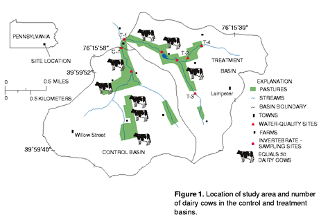
by presenting preliminary findings . STUDY BASIN The study area is a 3.2 square-mile watershed (fig.1) within the Mill Creek Basin. Land use in the study area is about 80 percent agricultural; the remaining land uses are either urban, residential, or commercial. Agricultural land in the basin is used primarily for dairy-cow pasture and hay and corn production. Approximately 12 farming operations are located within the study area. Farmers provide nutrient-application data and information on when the dairy cows are pastured. Cooperation from each farm operation is critical to the |
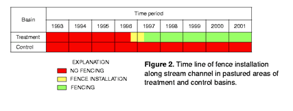
objectives of the study. Two adjacent basins comprise the study area. Basins are similar in land use, climate, topography, and geology. The stream channel will be fenced in pasture areas in one basin (treatment basin), while the other basin (control basin) will not be fenced. The treatment basin, which covers 1.4 square miles and includes 2.8 stream miles, contains about 150 dairy cows. The control basin, which covers 1.8 square miles and includes 2.7 stream miles, contains about 250 dairy cows (fig. 1). Presently, the majority of dairy cows in both basins have unlimited access to stream channels in pastured areas. Beginning in fall 1996, fencing on the treatment basin will be installed along 1.6 miles of stream channel adjacent to pastures. Fencing will be completed by early spring 1997 (fig. 2). |
||||||||||||||||||||||||
|
The Pequea Creek and Mill Creek Basins within Lancaster and Chester Counties in Pennsylvania have been identified as areas needing control of nonpoint-source (NPS) pollution to improve water quality. The two basins are a total of approximately 200 square miles and are primarily underlain by carbonate bedrock. Land use is predominantly agriculture. The most common agricultural NPS pollution-control practices implemented in the Pequea Creek and Mill Creek Basins are barnyard-run-off control and streambank fencing. To provide land managers information on the effectiveness of streambank fencing in controlling NPS pollution, a study is being conducted in two small paired watersheds within the Mill Creek Basin. |
||||||||||||||||||||||||||
| PROJECT DESCRIPTION |
|
|||||||||||||||||||||||||
|
The objective of the project is: |
||||||||||||||||||||||||||
|
To evaluate the effect of stream-bank fencing of pasture land on surface-and near-stream ground-water quality within a small watershed underlain by carbonate bedrock |
||||||||||||||||||||||||||
|
To attain the project objective, the hydrology and water quality of the study area needs to be characterized and quantitative relations between paired basins |
||||||||||||||||||||||||||
|
A cooperative effort between the US Geological Survey (USGS) and the Pennsylvania Department of Environmental Protection (PaDEP), this project supports the study initiative of the US Department of Agriculture within the Pequea and Mill Creeks Hydrologic Unit Area. The project is funded by PaDEP through the National Monitoring Program (NMP) of the US Environmental Protection Agency (USEPA). The NMP stems from Section 319 of the 1987 amendment to the Clean Water Act. The NMP was developed to document the effects of NPS pollution-control measures and associated land-use modifications on water quality (Osmond and others, 1995) |
||||||||||||||||||||||||||
Page 2 |
||||||||||||||||||||||||||
| The buffer strip between the fence and the
edge of the stream bank will be 10-12 feet on each side of the stream. Post-fencing
data will be collected through the year 2001. STUDY DESIGN A study design was developed that documents changes in surface-water
and ground-water systems that could result from streambank fencing. This
will be accomplished by collecting chemical, physical, and biological
data in the study basins. A paired-watershed comparison of |
water-quality characteristics at the outlets
of the treatment (T-1) and control (C-1) basins will be made before and
after fence installation in the treatment basin. Three other surface-water sampling sites are located within the treatment basin. At the most visually degraded site (T-2), which drains 0.36 square miles, data collected before and after fence installation will be compared to data from C-1 to determine changes in water quality (table 2). Upstream of T-1 and T-2, a surface-water site (T-4) was installed to determine the effect of a new (construction began 2 years after initial data collection for the study) residential development on water quality. One site (T-3) is located above most pastured area and will be compared to T-1 in an upstream/downstream design to determine effects of fencing. Ground Water |
|
||||||||||||||||||||||||
| Table 1. Data
collection in study area [NA, not applicable] |
||||||||||||||||||||||||||
|
|
|||||
|
Source
|
Type of data
|
Data collected1
|
Sites
|
Type of sample
|
Frequency of data collection
|
|---|---|---|---|---|---|
|
|
|||||
| Chemical and physical | Total and dissolved nutrients, suspended sediment, field measurements | T-1, T-2, T-3, T-4, C-1 | Fixed | Every 10 days, April - November; monthly, December - March | |
|
|
|||||
| Total and dissolved nutrients, suspended sediment | T-1, T-2, T-4, C-1 | Stormflow2 | 15-20 storms per year | ||
|
|
|||||
| Surface water | Biological | Fecal streptococcus | T-1, T-2, T-3, T-4, C-1 | Base flow | Monthly, January - December |
|
|
|||||
| Benthic macroinbertebrate | T-1, C-1, and upstream sites | Base flow | May and September | ||
|
|
|||||
| Discharge | T-1, T-2, T-4, C-1 | NA | Continuous | ||
| Flow |
|
||||
| T-3 | NA | Intermittent | |||
|
|
|||||
| Chemical | Dissolved nutrients, field measurements, and alkalinity | Nest of 4 wells at T-1, nest of 4 wells at T-2 | Fixed | Monthly, January - December | |
|
|
|||||
| Ground water | Biological | Fecal streptococcus | |||
|
|
|||||
| Water level | Depth below land surface | Nest of 4 wells at T-1, nest of 4 wells at T-2 | NA | Continuous | |
|
|
|||||
| Agricultural activity | Physical | Number of cows and time in pasture, nutrient application to farm land | All farms in the treatment and control basins | NA | Continuous |
|
|
|||||
| Precipitation | Physical | Quantity | T-1 | NA | Continuous |
|
|
|||||
| 1. Total nutrientsammonia plus
organic nitrogen, phosphorus; dissolved nutrientsnitrite and nitrate, ammonia,
ammonia plus organic nitrogen, phosphorus, orthophosphorus; field measurementspH,
temperature, specific conductance, and dissolved oxygen. 2. Samples are collected by automatic samplers during the entire storm event. Flow-weighted composite storm samples are submitted for analyses. |
|||||
Page 3 |
|||||
| samples from the wells will be used to help
explain observed changes in base-flow stream quality before and after fencing.
Water-level measurements will show the hydraulic potential for groundwater
movement toward and away from the stream, which will aid in the interpretation
of the stream-chemistry data. PRELIMINARY DATA ANALYSIS This section focuses on the paired-watershed approach to the study design.
Chemical, physical, and benthic-commu-nity data presented here were collected
from T-1 and C-1 from June 1993 through December 1995, during the pre-fencing
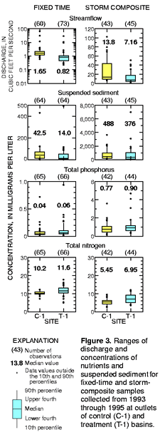
time period. Data collected at the outlets of control and treatment basins from 1993
to 1995 indicate that concentrations of total nitrogen and phosphorus
(fig. 3) in stream-flow were similar at T-1 and C-1. Nutrient concentrations
from the study area are relatively high compared to concentrations for
other water-quality sites within the Chesapeake Bay drainage basin (Langland
and others, 1995). |
 |
same constituents measured at the outlet of
the control basin (C-1). If relations between the two outlets are not significant,
there is no chance of detecting a significant change in water quality caused
by fencing. If relations are significant, then the likelihood of detecting
a change based on a fixed number of samples can be determined. Such pre-treatment
analysis can be used to guide post-fencing sampling procedures. At the end
of the post-fencing period, analysis of covariance will be applied to the
regressions developed for before and after treatment to determine the effect
of streambank fencing on water-quality constituents. This procedure is discussed
thoroughly by Clausen and Spooner (1993). Regression equations developed
for data from storm-composite and fixed-time samples collected from 1993
to 1995 at the outlets of the control and treatment basins for all nutrients
listed in table 1 and suspended sediment were significant at an alpha level
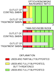
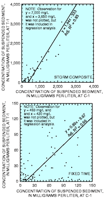
of 0.05. As an example, regression equations for both storm-composite and fixed-time samples developed for the concentration of suspended sediment for T-1 against the concentration of suspended sediment for C-1 are shown in figure 4. The higher adjusted R 2 for the storm-composite regression and the actual distribution of data indicate less variation for the storm-composite data relative to the fixed-time data. The lower the variability in pretreatment data, the better the likelihood of detecting significant changes in water quality after the fencing has been installed. Therefore, it appears that there is a better likelihood of detecting a significant change in suspended-sediment concentrations from storm-com-posite samples than from fixed-time samples collected at the outlets of the treatment and control basins. Based on preliminary analysis of storm-composite and fixed-time data, the streambank fencing project within the Mill Creek Basin can progress forward with fence installation in the fall of 1996. Statistical relations evident between the outlets of the control and treatment basins will allow for the detection of any significant changes in water-quality constituents caused by streambank fencing. Benthic-community data Benthic-macroinvertebrate samples are used to indicate the overall health of the stream. Two metrics of invertebrate community health will be used, the EPT/ Chironomidae abundance ratio and taxa richness. The EPT/Chironomidae abundance ratio compares the relative abundance of three orders of aquatic insects (Ephemeroptera, Plecoptera, and Tri-choptera), which require clean water, |
||||||||||||||||||||||||||||||||||||||||||||||||||||||||||||||||||||||||||
|
||||||||||||||||||||||||||||||||||||||||||||||||||||||||||||||||||||||||||||
Page 4 |
||||||||||||||||||||||||||||||||||||||||||||||||||||||||||||||||||||||||||||
 |
of impact as discussed by Bode and others (1993)
was used as a guideline for converting the biological data into terms that
are in accordance with NMP guidelines. A fully supported stream would support
all the typical uses for that water body. A partially supported stream is
somewhat degraded and thus would not support all the typical uses for that
water body (US Environmental Protection Agency, 1991). The metrics used to measure community health indicate that the designated uses within the treatment basin at T-1 are fully supported; however, within the control basin at C-1, the EPT/Chironomidae abundance ratio indicates the designated uses are fully supported but threatened (fig. 5). |
Langland, M.J., Lietman, P.L., and
Hoffman, S., 1995, Synthesis of nutrient and sediment data for watersheds
within the Chesapeake Bay drainage basin: U.S. Geological Survey Water-Resources
Investigation Report 95- 4233, 121 p. Osmond, D.L., Line, D.E., and Spooner, J., 1995, Section 319 National Monitoring Program -- An overview: NCSU Water Quality Group, Biological and Agricultural Engineering Department, North Carolina State University, Raleigh, North Carolina, 13 p. Pennsylvania Department of Environmental Resources, 1994, Pennsylvania Code Chapter 93. Water quality standards: Bureau of Water Quality Management, 212 p. Plafkin, J.L., Barbour, M.T., Porter, K.D., Gross, S.K., and Hughes, R.M., 1989, Rapid bioassessment protocols for use in streams and rivers: U.S. Environmental Protection Agency, EPA/444/4-89-001, 176 p. U.S. Environmental Protection Agency, 1991, Watershed monitoring and reporting for section 319 national monitoring program projects: U.S. Environmental Protection Agency, Office of Water, Washington, D.C., 112 p. CONTACTS FOR FURTHER INFORMATION All water-quality and water-quantity data collected for this study are pub-lished in the USGS Annual Data Reports for water years 1994 and 1995 for the Susquehanna and Potomac River Basins. If interested in these reports, please contact the following: U.S. Geological Survey 215 Limekiln Road New Cumberland, Pennsylvania 17043 (717) 730-6900 Copies of this fact sheet can be purchased from: U.S. Geological Survey Branch of Information Services Box 25286 Denver, Colorado 80225-0286l Fo r additional information about USGS programs and activities in Pennsylvania, please visit our web site at: / Dan iel G. Galeone and Edward H. Koerkle1996 |
| Figure 4.
Concentrations of suspended sediment at the outlet of the treatment basin
(T-1) as a function of the control basin (C-1) for storm-composite and fixed-time
samples collected from 1993 through 1995. to a family of aquatic insects (Chironomidae), which is generally tolerant of degraded water quality. Thus, the higher the metric score, the better the water quality. Taxa richness is simply the total number of taxa present. Generally, larger taxa richness values denote better water quality (Plafkin and others, 1989). Water-quality criteria are applied to streams based on the uses designated for that stream. Designated uses for streams in the Pequea Creek and Mill Creek Basins include warm-water fishes, cold-water fishes, trout stocking, and high quality waters (Pennsylvania Department of Environmental Resources, 1994). By comparing the EPT/Chironomidae abundance ratio or the taxa richness score to scores from reference stations, an evaluation is made about the ability of the sampling site to support its designated uses. For this study, because reference stations are not available, best professional judgment was used to designate levels of stream health. The typical four-tiered classification system based on the level August 1996 |
Figure 5. Benthic-macroinvertebrate metrics for samples collected during spring and fall 1994 and 1995 at outlet of control and treatment basins |
|
| REFERENCES CITED Bode, R.W., Novak, M.A., and Abele, L.E., 1993, 20 year trends in water quality of rivers and streams in New York state based on macroinvertebrate data 1972-1992: NewYork Department of Environmental Conservation, 196 p. Clausen, J.C., and Spooner, J., 1993, Paired watershed study design: U.S. Environmental Protection Agency, 841-F-93-009, 8 p. |
*U.S. GOVERNMENT PRINTING OFFICE: 1996-712-561
FS-193-96