(Larger Version, 97K GIF)
Since the late 1890's, the U.S. Geological Survey (USGS) has been mapping, collecting, and interpreting earth-science data in Alaska. This long-term endeavor continues today, enhanced by the inclusion of the National Biological Service in 1996. The USGS, with six offices in Alaska, provides information about the State's natural hazards, landscape, natural resources, fish, wildlife, and environment.
Volcanic eruptions are a part of life in Alaska. One of the most vital roles of the USGS is to define and mitigate the risk of these volcanoes. The USGS uses modern geologic techniques to determine and portray the likelihood and severity of potential volcanic eruptions, thereby contributing to community preparedness and minimizing their impact.
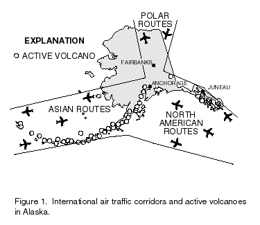
Alaska has more than 40 active volcanoes that have averaged two significant eruptions every year since 1945. Most of Alaska's volcanoes lie along a 1,600-mile arc from the Aleutian Islands, through the Alaskan Peninsula, and into south-central Alaska (fig. 1). Damage from these volcanoes has amounted to more than $400 million in the last decade. Ashfall from eruptions in upper Cook Inlet has repeatedly affected communities in Alaska, most recently in 1992. Additionally, volcanic ash is a severe threat to jet aircraft that fly over the North Pacific Ocean. On an average of 4 days each year, explosive eruptions send clouds of ash directly into international air-traffic routes in and near Alaska. Anchorage International Airport is the busiest cargo hub in the United States. With cargo and passenger air traffic in the North Pacific steadily rising, rapid detection and notification of eruptions beneath Alaskan air routes are increasingly critical.
|
(Larger Version, 97K GIF) |
| Figure 1. International air traffic corridors and active volcanoes in Alaska. |
![]()
To address this need, the Alaska Volcano Observatory (AVO), a cooperative program of the USGS, the University of Alaska Geophysical Institute, and the Alaska Division of Geological and Geophysical Surveys, was established in 1988. The AVO has three principal objectives: to monitor volcanoes and issue timely eruption notifications, to assess and communicate volcanic hazards, and to provide information that might assist in mitigation of volcano risks.
Successful advance warnings by the AVO during the 1989-90 eruptions of Redoubt Volcano, the 1992 eruptions of Spurr Volcano, and recently in nearby Kamchatka, Russia, reduced personal, social, and financial impacts on affected communities
Alaska is the most earthquake-prone State in the Nation and one of the most seismically active regions in the world. A magnitude 7 earthquake occurs almost every year; a magnitude 8 or greater earthquake occurs about every 14 years. Many critical transportation, communication, and oil transfer facilities in Alaska are located in regions of high earthquake risk. The USGS, in cooperation with the University of Alaska and other Federal agencies, records earthquake activity in the State, and helps to define the seismic hazards. In addition, the USGS is a partner in the Alaska Earthquake Information Center in Fairbanks, which performs round-the-clock earthquake recording and analysis and disseminates information on the State's earthquakes to the public, media, and government agencies.
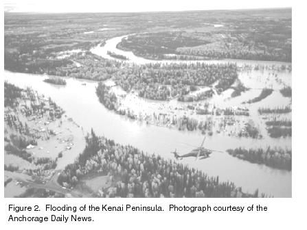
Many of Alaska's communities and transportation facilities are located along large rivers and are subject to flooding caused by rainfall, seasonal meltwater, and ice dams. USGS personnel survey flooded areas such as south-central Alaska in 1995 (fig. 2) by collecting and assessing information about water levels, discharge, and damage so that flood frequencies and magnitudes along rivers and streams throughout the State can be predicted. The information is used for flood warning, flood-plain management, and risk assessment purposes by such agencies as the U.S. Army Corps of Engineers, the Federal Emergency Management Agency, the National Weather Service, the Alaska Department of Community and Regional Affairs, other governmental planning and zoning agencies, and by insurers, industry, developers, and private landowners. Unstable channel bottoms and riverbanks, high stream sediment loads, and streamflow diversion by icings frequently contribute to high maintenance costs for highways, bridges, and culverts throughout the State. The USGS, in cooperation with the Alaska Department of Transportation and Public Facilities, surveys selected bridge sites and collects hydraulic data for analysis of bridge-scour processes. The information is used to assess bridges that may be at risk of failure during floods.
 (Larger Version, 194K GIF) |
| Figure 2. Flooding of the Kenai Peninsula. Photograph courtesy of the Anchorage Daily News. |
USGS biologists study fish, wildlife and their habitats in marine, freshwater, and terrestrial ecosystems throughout Alaska and in other circumpolar countries. The mission of the new Biological Resources Division (BRD, formerly the National Biological Service) of the USGS is to provide the scientific understanding and technologies needed to support the sound management and conservation of our Nations's biological resources.
The USGS has two BRD organizations in Alaska: the Alaska Cooperative Research Unit at the University of Alaska in Fairbanks and the Alaska Biological Science Center in Anchorage. The program of the Cooperative Unit is directed at understanding the ecology of Alaska's fish and wildlife, evaluating impacts of land use and development on these resources, and relating effects of social and economic needs to production and harvest of natural populations.
Research programs of the Alaska Biological Science Center in Anchorage address:
Natural resource management issues addressed by the Alaska Center include:
The Center has field stations at Denali National Park and Preserve, Kodiak National Wildlife Refuge, and Glacier Bay National Park and Preserve. Most of the biological research is conducted in Alaska. However, part of the research also is international in scope and includes cooperative agreements with Russia to study marine mammals, migratory birds, Pacific salmon, and polar bears; with Canada to study caribou; and with Mexico to study shared migratory bird populations.
Field studies are ongoing in Prince William Sound, Cook Inlet, Gulf of Alaska, the Bering and Chukchi Seas, and units of the National Wildlife Refuge system (including the Arctic, Kodiak, Izembek, Yukon Delta, Kenai, and Alaska Maritime Refuges), and units of the National Park system (including Denali, Wrangell�St. Elias, Glacier Bay, Katmai, and Kenai Fjords National Parks and Preserves).
Glacier Bay and Prince William Sound� Copper River are two of 12 regions in the Nation selected for ecosystem initiatives by the Department of the Interior (DOI). The USGS piloted and funded a partnership effort of Federal, State and Native organizations in these two regions to promote an ecosystem perspective for the continued use and wise management of natural, cultural, and other resources, and to work faster and more economically in partnership rather than alone.
The USGS helped sponsor an invitational workshop at the University of Alaska in Fairbanks in June 1997, designed to identify tangible effects of global change on the Arctic environment. Participants identified impacts on ocean-fish systems, coastal zones, land ecosystems, resources, and infrastructure. They also discussed research and management strategies to prepare for and respond to these changes. Issues of importance to Alaska have been identified for discussion at national conferences addressing the impact of global change.
Changes in the distribution of snow and ice in the Arctic are recognized as early indicators of global climate change. The USGS helps to monitor these changes in Alaska by measuring changes in ice volumes and in glacier discharge and movement. Field data are collected and used to calibrate remotely sensed information for the entire Arctic. This information is used by international cooperators and others in studies of global climate change.
Perennially frozen ground (permafrost) underlies about 85 percent of Alaska. USGS permafrost studies, which played a major role in the success of engineered structures such as the Trans-Alaska Pipeline, now are being used to help monitor climate change. USGS scientists are studying borehole temperatures on the North Slope and have found that this region already has warmed 2 to 4 degrees Celsius during this century.
Ongoing studies of plant fossils (leaves, wood, and pollen) from Alaska by USGS scientists provide important insights on the relationships between climate change and ecosystem changes. Fossils from natural exposures and sediment cores permit detailed reconstructions of past environments under a variety of climates during the past 18 million years.
In 1989, the USGS initiated the Arctic Processes and Land Characterization project, which has grown into an international activity that addresses circumpolar vegetation and ecoregion mapping activities. Twenty ecoregions of Alaska have been mapped and described by the USGS, in cooperation with the U.S. Environmental Protection Agency and Colorado State University, to serve as a framework for organizing and interpreting environmental data relevant to a wide range of regional ecological concerns. The ecoregions of Alaska are described in the "Ecoregions Map of North America," and further efforts are underway to delineate ecoregions of all the northern circumpolar areas. These data support international programs that are designed to assess and monitor global resources.
The "Arctic Environmental Data Directory" was developed in 1988 by the USGS and is being used as the initial repository for information on the Arctic in support of the Arctic Research and Policy Act. The directory can be accessed through the World Wide Web at:
http://www-ak.wr.usgs.gov/aedd/
Alaskan oil production peaked in 1988, and since then has declined at a rate of nearly 4 percent per year. However, the Prudhoe Bay oil field is the largest in North America, and production from it and five other nearby North Slope oil fields amounts to about one-quarter of U.S. oil production.
USGS investigations of oil and gas production are directed at an improved understanding of onshore oil and gas resources in Alaska to reduce uncertainty in estimating the amount of undiscovered oil and gas. Current activities include studies on the North Slope, Interior Alaskan basins, gas-hydrates, coalbed methane, and petroleum systems. The activities are conducted in cooperation with State and Federal agencies, universities, and private industry.
Information on the undiscovered oil and gas resources of Alaska, which is part of the 1995 national assessment, is available on CD-ROM and in a pamphlet. Alaskan coal studies by the USGS are being included in the national assessment of undiscovered coal resources.
The USGS continues to assess the undiscovered mineral resource potential of Federal public lands in Alaska as required by the Alaska National Interest Lands Conservation Act of 1980. The USGS activities are designed to collect high-quality data used in assessments, understand the processes of ore genesis, and identify the environmental impact of naturally weathering mineral occurrences and in developed mines. This information is critical to making wise resource-management decisions.
Digital data bases of geologic, geochemical, geophysical, and mineral information in digital formats make them more easily analyzed and accessible. These are being prepared in cooperation with the State of Alaska, other Federal agencies, academia, and industry.
Alaska is the site of several significant mineral deposits and mineral districts. The USGS is studying the regional setting and processes of the genesis of these deposits and districts. In Wrangell�St. Elias National Park, the environmental impact of past mining activity is being evaluated to help park managers make prudent land-management decisions. Geochemical baseline studies are being established for areas around mines that might undergo future development (as private holdings inside the Park).
Naturally occurring concentrations of toxic elements such as mercury and arsenic are being investigated in parts of east-central Alaska and in southwestern Alaska to compare them with concentrations of those elements induced by mining.
The USGS supports accurate, standardized geologic mapping in each State through the statemap program. Alaska has used funds from the USGS for geologic mapping near Fairbanks in support of mineral-resource-oriented studies and to address significant hazards including landslides and earthquakes. The new mapping also is important for mineral exploration and for updating existing geologic maps.
The USGS serves as the central repository and distribution agency for surface-water, ground-water, and water-quality data. These data are used to address issues such as the availability, allocation, and use of the resource; purity of drinking-water supplies; flood risk and flood-plain management; engineering design and construction; fish and wildlife management; and waste disposal control and remediation.
The USGS has operated and maintained hydrologic data-collection networks in Alaska since 1946, in cooperation with other Federal, State, and local agencies. The data collected are reported annually in a publication titled "Water Resources Data�Alaska," and also are available on the World Wide Web. The USGS currently records water discharge at 85 gaging stations, peak-flow data at 60 crest-gage stations, water levels at more than 180 observation wells, and water quality at several key sites. Data from more than 2600 sites are included in the surface- water database.
An essential role of the USGS in Alaska is to investigate the vulnerability of drinking-water supplies to contamination. Such investigations recently were conducted at 65 Federal Aviation Administration facilities across the State, 5 current or former military installations, the University of Alaska at Fairbanks, Fairbanks International Airport, and the Alaska Railroad industrial area in Fairbanks. The results of investigations in the Fairbanks area are being incorporated into an areawide ground-water model for predicting water-table elevations and ground-water flow directions. Information of this type is used by individual property owners, developers, land-use planners, municipal officials, and resource-management and health agencies. In Alaska, the Cook Inlet region has been selected for study under the USGS National Water-Quality Assessment Program. An important goal of the program is to make relevant findings about current conditions, trends, and major factors that affect water quality.
The effects of riverbank development on fish habitat are of increasing concern to fishery management agencies. The Kenai River is the most popular sport fishing river in south-central Alaska, and areas of the river's banks are densely developed by private landowners. Supported by the Alaska Department of Fish and Game, the USGS has investigated the hydraulic conditions near selected manmade streamside structures to assess the effects of development upon juvenile salmon habitat in the river. The resulting information will help to plan management programs for the Kenai River.
A network of magnetic observatories continuously records the Earth's magnetic field nationwide. Three of the 13 geomagnetic observatories operated by the USGS are located in Alaska�at Barrow, College, and Sitka. The College International Geophysical Observatory near Fairbanks is a new and modern facility, operated in cooperation with the Geophysical Institute of the University of Alaska. Magnetic data obtained by the observatories are incorporated into nautical and aeronautical navigation charts and topographic maps.
In support of the USGS mission to provide information about the Earth and its physical resources, the National Mapping Program acquires and disseminates geographic, cartographic, and remote sensing information for Alaska. The program provides maps, technical assistance, and research programs that apply to the needs of the region and the Nation. The USGS carries out these activities in Alaska primarily through the development of cooperative programs and partnerships with agencies and organizations involved with resource mapping and the management community. These cooperative arrangements result in cost savings to the participating organizations and to private citizens who also use the products and services of the program.
Topographic maps are among the most popular and versatile products of the USGS. These maps depict elevation and natural and cultural features of the landscape, such as lakes and streams, highways and railroads, boundaries, and geographic names. Topographic maps have a wide range of uses in Alaska, from civil engineering and natural resource monitoring to outdoor activities of hiking, exploring, hunting and back-country fishing expeditions.
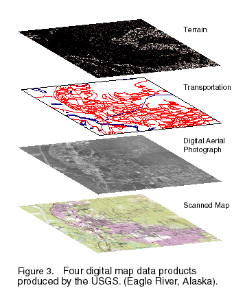
The USGS, in response to the increasing demand of Federal and State land-management agencies for digital map and data products, has undertaken a program to complete a digitally based mapping program at 1:63,360 scale for the entire State. This digital mapping program, done in partnership with those agencies, will provide comprehensive statewide coverage for hydrography (lakes, rivers, shorelines), terrain (digital elevation models), transportation (roads, pipelines, railroads), aerial photography (digital orthophoto quads), as well as a computer scanned image of each USGS paper map product that exists for the State (fig. 3). This cooperative effort, funded largely by the DOI, also relies heavily on private industry participation; because the bulk of the actual work of digitizing the maps is performed by contractors.
 (Larger Version, 97K GIF) |
| Figure 3. Four digital map data products produced by the USGS (Eagle River, Alaska). |
The Alaska mapping and resource management community is heavily invested in computer-based mapping and Geographic Information Systems (GIS) technology. In direct support of computer mapping and GIS technology, the USGS operates a geoprocessing computer laboratory in Anchorage, the only one of its kind in the Nation. This facility provides government agencies with access to data from earth orbiting satellites, digital image processing systems, and GIS software to address a broad range of natural resource issues.
The key to the development of the Alaska digital mapping program has been the Alaska Geographic Data Committee (AGDC). The AGDC, which consists of 19 Federal and five State agencies, was established by the USGS and other Federal and State agencies to coordinate Alaska mapping requirements and geospatial data-development projects, to define and implement standards, and to review and respond to initiatives of the Federal Geographic Data Committee (FGDC). The USGS, in support of the digital mapping programs promoted by the AGDC, has developed an AGDC Geospatial Data Clearinghouse, which provides access by way of the Internet to all of the geospatial data holdings of the participating agencies. The USGS and the AGDC, through their efforts in increasing the production and accessibility of geospatial information, are helping Federal, State, and local agencies and institutions to address and solve concerns of these agencies and society.
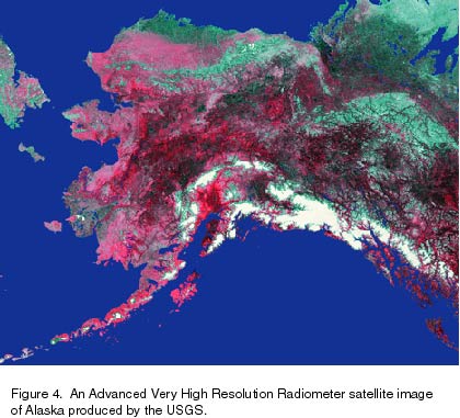
Earth Science Information Centers (ESIC's) provide information about the USGS, its programs, products, and technological developments to the public, and also offer USGS products for purchase (fig. 4). An ESIC office in Anchorage and a State-affiliate office at the Geophysical Institute in Fairbanks provide information on topics such as cartography, geography, biology, digital data, remote sensing, geology, geophysics, geochemistry, hydrology, geohydrology, aerial photography, and land use. These offices are supported by the USGS with reference materials, technical assistance, training and outreach activities, and access to USGS data bases.
 (Larger Version, 97K GIF) |
| Figure 4. An Advanced Very High Resolution Radiometer Satellite Image of Alaska produced by the USGS. |
from U.S. Department of the Interior, U.S. Geological Survey, Fact Sheet FS-001-96
For more information contact any of the following: | |
|
USGS State representative 4230 University Drive Suite 230 Anchorage, AK 99508-4664 (907) 786-7100 Fax: (907) 786-7150 Email: dc_ak@usgs.gov
Additional earth science
For more information on
|
The USGS provides maps, reports, and information to help
others meet their needs to manage, develop, and protect America's water,
energy, mineral, biological, and land resources. We help find the natural
resources needed to build tomorrow and supply the scientific understanding
needed to help minimize or mitigate the effects of natural hazards and
environmental damage caused by natural and human activities. The results
of our efforts touch the daily life of almost every American.
|
This fact sheet is also available in pdf format:
![]() fs-001-96.pdf
fs-001-96.pdf
| AccessibilityFOIAPrivacyPolicies and Notices | |
 |
|