Flood Magnitude and Frequency
Floods are a natural hazard in Alabama. Damage from severe floods cannot be averted completely, but with sound hydrologic information, reliable estimates of peak river stages and discharge can be made, and communities can be warned of impending danger. With accurate estimates of flood magnitude and frequency, planners and managers can improve the design of highway bridges and culverts, determine locations for water- and wastewater-treatment facilities, prepare zoning ordinances, and establish flood-insurance rates. The USGS has developed methods of estimating peak discharges for floods of various recurrence intervals for rural streams in Alabama not affected by regulation or urbanization. Flood-frequency characteristics have been defined for 200 streamflow-gaging stations that have 10 or more years of record through September 1991.Coal Assessment
Little River Canyon--A New National Park
The National Park Service (NPS) recently purchased about 9,000 acres of land from the Alabama Power Company to form the Little River Canyon National Preserve; it is the first major national park in Alabama. An additional 5,000 acres of State-owned land, which includes DeSoto State Park, will be donated to the Preserve. Another 130 acres owned by Cherokee County also will be acquired.
Monitoring the Quality of Public Water Supplies
For several years, the USGS has had ongoing cooperative agreements with the cities of Tuscaloosa, Birmingham, and Mobile to monitor the quality of water in their public supply reservoirs. All three cities were concerned that various land uses within the drainage basins of the reservoirs could have a negative effect on the quality of the water in the reservoirs. In the case of Tuscaloosa, the major concerns were strip mining for coal and residential development within the basin. In Birmingham, the concerns were residential development and industrial discharges. In Mobile, the concerns are plant nurseries, logging activities, and the transport of hazardous chemicals and material across the reservoir on a major U.S. highway and railroad, as well as residential development. In all cases, the basic study involves monitoring the major tributaries of the reservoirs to establish a baseline of water-quality data.Topographic Mapping
The use of maps and digital cartographic data is widespread, and demands for this information are expanding dramatically. The National Mapping Program of the USGS strives to ensure the availability of map data in graphic and digital forms to the general public through timely and effective data-collection and revision procedures. Among the most popular and versatile products of the USGS are its 1:24,000-scale topographic maps (1 inch on the map represents 2,000 feet on the ground). These maps depict natural and cultural features of the landscape, such as lakes and streams, highways and railroads, boundaries, and geographic names. Alabama is covered by 912 maps at this scale, most of which were produced under cooperative arrangements with State agencies. The Program fosters partnerships with State and Federal agencies to improve the effectiveness of its data-collection activities, to maximize resource sharing, and to enhance the availability of timely and accurate data to the general public.Earth Science Information Center
The Earth Science Information Centers (ESIC) provide information about USGS programs, products, and technological developments to the public. The ESIC in Tuscaloosa was established under a cooperative agreement between the USGS and the Geological Survey of Alabama. As part of the national ESIC network, this office provides information on such earth science topics as cartography, geography, digital data, remote sensing, geology, geophysics, geochemistry, hydrology, geohydrology, aerial photography and land use. It is supported by the USGS with reference materials, technical assistance, training and outreach activities, and access to USGS data bases.Geologic Mapping
Mineral-Resource Information
The USGS Minerals Information Team collects, analyzes, and disseminates information on the domestic and international supply and demand for minerals and materials essential to the U.S. economy and National security. In 1995, the estimated $676 million worth of minerals produced in Alabama for uses other than fuel was ranked 18th in value among nonfuel minerals produced by the 50 States, and it was slightly less than 2 percent of the total value of nonfuel minerals produced in the United States. The most valuable nonfuel mineral products from Alabama were portland cement, crushed stone, lime, and construction sand and gravel; the value of these four products accounted for about $581 million or almost 86 percent of the value of nonfuel mineral products from Alabama.
Collection of Hydrologic Data
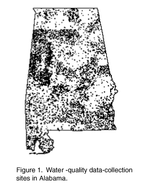 (Larger Version, 194K GIF) |
| Figure 1. Water-quality data-collection sties in Alabama. |
Biological and Ecological Studies
The USGS is tracking the abundance and locations of sensitive species, such as the white-topped pitcher plant, wherryŐs red pitcher plant, HenslowŐs sparrow, and other species found on forested lands in southern Alabama and the Gulf Coastal Plain. By understanding the habitat requirements of rare species like these, timber harvest can be designed to be compatible with species protection. Research on foraging patterns of wading birds in west-central Alabama has helped the Catfish Farmers of America and the Alabama State Catfish Committee design ponds that are less vulnerable to fish-eating birds. The National Wetlands Research Center in Lafayette, Louisiana, has mapped seagrasses on the coast of Alabama as part of the U.S. Environmental Protection AgencyŐs EĐMap Program to assess the status of seagrasses in the Gulf of Mexico and to determine long-term monitoring locations.
The USGS is participating in the Appalachian Clean Streams Initiative, along with other Federal, State, and local government agencies; local Natural Heritage associations and community groups; industry; and academia. The goal for the Initiative is to develop a comprehensive plan for acidic-mine drainage prevention and restoration. In Alabama, efforts are focused on the Coal Valley watershed, which feeds into the Mulberry Fork of the Black Warrior River. Scientists also are working to determine the range and abundance of six species of imperiled freshwater mussels in the Apalachicola, the Chattahoochee, and the Flint Rivers.
Evolution and History of Buried Valleys--Benefits to Shoreline Erosion Mitigation
Erosion along the Gulf Coast of Alabama is being combated by State and local agencies through the addition of sand to the seaward parts of wetlands and through other strategies. This enables natural erosion processes to take place without destroying the fragile wetlands. The USGS contributes to this effort by supplying information on the distribution of sand and clay deposits, and also by explaining the nature of modern shoreline processes. Knowing the location of buried, sand-filled channels, which were created when sea level was lower during an ice age, is particularly important. This information helps the State predict which engineering strategies are most likely to succeed in achieving a stable shoreline.Water-Resources Investigations in Baldwin County
The USGS, in cooperation with the Baldwin County Commission, is collecting data on ground-water availability and surface-water quality. The county is 100 percent dependent on ground water for public supply. Ground-water withdrawals were estimated to be about 30 million gallons per day in 1990. The objectives of the ground-water study are to describe the ground-water system, to locate areas where the ground-water system is stressed, to estimate the future availability of ground water, and to assess potential effects of alternative water-use management strategies.
The USGS inventoried 174 wells in Baldwin County. The water levels in 158 of those wells were measured during fall 1994. The water-level data collected are being used to construct a map of the potentiometric surface of the Miocene aquifer system, which supplies most of the ground water used in the county. Such maps summarize conditions in the ground-water system and are used to predict generalized directions of flow of ground water, to identify areas of recharge and discharge, and to locate areas where the aquifer is stressed.
Owing to increased stresses being placed on streams in the county from point and nonpoint pollution sources, concerns exist as to whether the streams are being affected by changes in land use and, if so, how severe those effects are. The USGS began an evaluation of the quality of water in the creeks and rivers by conducting a survey of 32 surface-water sites. On the basis of the findings, six fixed-station sampling sites were chosen for monthly sampling of water quality.
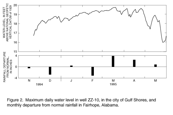 (Larger Version, 194K GIF) |
| Figure 2. Maximum daily water level in well ZZ-10, in the city of Gulf Shores, and monthly departure from normal rainfall in Fairhope, Alabama. |
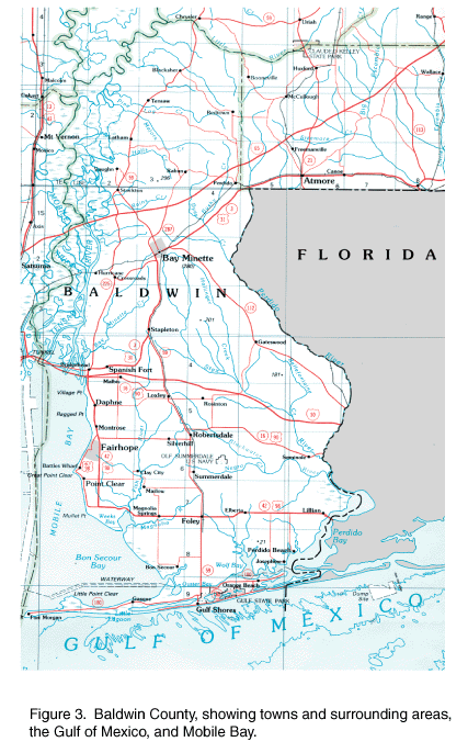 (Larger Version, 194K GIF) |
| Figure 3. Baldwin County; showing towns and surrounding areas, the Gulf of Mexico, and Mobile Bay. |