Fact Sheet 105-99
By Martin R. Risch
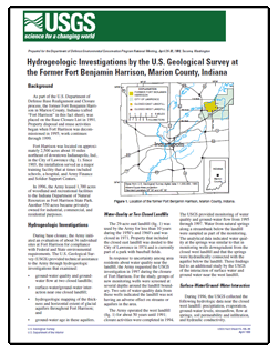
IntroductionAs part of the U.S. Department of Defense Base Realignment and Closure process, the former Fort Benjamin Harrison in Marion County, Indiana (called “Fort Harrison” in this fact sheet), was placed on the Base Closure List in 1991. Property disposal and reuse activities began when Fort Harrison was decommissioned in 1995; work continues through 1999. Fort Harrison was located on approximately 2,500 acres about 10 miles northeast of downtown Indianapolis, Ind., in the City of Lawrence (fig. 1). Since 1903, the installation served as a major training facility that at times included schools, a hospital, and Army Finance and Soldier Support Centers. In 1996, the Army leased 1,700 acres of woodland and recreational facilities to the Indiana Department of Natural Resources as Fort Harrison State Park. Another 550 acres became privately owned for industrial, commercial, and residential purposes. |
For additional information contact: U.S. Geological Survey Home Website http://www.usgs.gov/ Part or all of this report is presented in Portable Document Format (PDF); the latest version of Adobe Reader or similar software is required to view it. Download the latest version of Adobe Reader, free of charge. |

![]() U.S. Department of the Interior |
U.S. Geological Survey
U.S. Department of the Interior |
U.S. Geological Survey
URL: https://pubsdata.usgs.gov/pubs/fs/1999/fs105-99/
Page Contact Information: Contact USGS
Page Last Modified: Tuesday, 29-Nov-2016 18:11:27 EST
