During 1992–94, the U.S. Geological Survey (USGS), in cooperation with the North Central Texas Council of Governments (NCTCOG) collected stormwater runoff data for the cities and Texas Department of Transportation (TxDOT) Districts in the Dallas-Fort Worth (DFW) area to meet the regulatory requirements of the application phase for the National Pollutant Discharge Elimination System (NPDES) stormwater permit. The Phase I permit requirements applied to cities with populations of 100,000 or greater and to TxDOT districts with population centers of 100,000 or greater (U.S. Environmental Protection Agency, 1990). The following cities and districts in the DFW area met the population criteria: Arlington, Dallas, Fort Worth, Garland, Irving, Mesquite, Plano, TxDOT Dallas District, and TxDOT Fort Worth District. The permit applications were submitted to the U.S. Environmental Protection Agency (EPA) for approval.
Beginning in 1997, the approved stormwater discharge permits were issued to the seven cities and two TxDOT districts that required a permit-compliance phase with additional sampling for a 5-year period. In 1997, the USGS began a study in cooperation with the NCTCOG to collect stormwater samples and characterize stormwater runoff for the seven cities and two TxDOT districts for the period 1997–2001. At the end of the 5-year permit-compliance phase, the EPA will transfer the stormwater discharge permits to the Texas Natural Resource Conservation Commission for renewal. The USGS, during an ongoing study, will analyze the data collected during the permit-compliance phase and recommend possible changes to the network design and sampling schedule. This fact sheet describes the monitoring network and sampling schedule during the permit-application phase and the 5-year permit-compliance phase (1997–2001) and summarizes the sampling during February 1997–February 2000.
The DFW area is located in north-central Texas (fig. 1), and the 1,700-square-mile area lies within Collin, Dallas, Denton, and Tarrant Counties. The DFW area is in the upper Trinity River Basin with three major tributaries of the Trinity River draining the area—West Fork Trinity River, Elm Fork Trinity River, and East Fork Trinity River. Mean annual precipitation in the study area varies from about 31 inches in Tarrant County to 36 inches in Dallas County, with the months of April and May typically the wettest and the months of July and August the driest (Ramos, 1999).
During the permit-application phase, 30 monitoring sites were established during 1992–93 in small (160 acres or less) drainage basins, each categorized by a single predominant land use (11 residential, 9 industrial, 6 commercial, and 4 highway). Five sites each were located in the cities of Dallas and Fort Worth, four in Arlington, three each in Garland, Irving, Mesquite, and Plano, and two sites each in TxDOT Dallas and TxDOT Fort Worth. Fifteen of the original 30 monitoring sites (1–15, table 1) were reactivated in 1997 for the permit-compliance phase, including 4 residential, 4 industrial, 4 commercial, and 3 highway. Three sites each are located in Dallas and Fort Worth, two sites each in Arlington and TxDOT Dallas, and one site each in Garland, Irving, Mesquite, Plano, and TxDOT Fort Worth. The remaining 15 sites were discontinued (16–30, table 1). Seven new sites (31–37, table 1) were established during 1997–98 for the permit-compliance phase. One site is located in each of the seven cities; no new TxDOT sites were established. Six of the new sites are located in drainage basins with mixed land use, and one site is located in an undeveloped drainage basin. Three of the six sites with mixed land use are located at outfalls with drainage areas less than 500 acres, and the remaining three sites are located instream with drainage areas of at least 2,500 acres (table 1). Most of the monitoring sites are located at storm sewer outfalls or concrete-lined open channels. Two sites are located at natural channels.
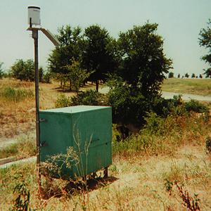
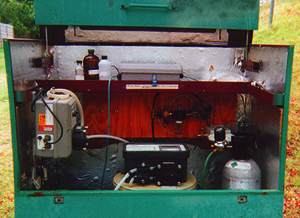
Each site houses the monitoring equipment in a shelter (photo A). A rain gage and solar panel are attached to the shelter. Inside the shelter (photo B) are an automatic sampler, a peristaltic pump, a datalogger, and a gas bubbler system. The stage of the water in a culvert or open channel is measured using a pressure transducer and a gas bubbler system that regulates the periodic release of a bubble of carbon dioxide through an orifice line below the water surface. The pressure transducer measures the pressure required to force the bubble out of the orifice line and converts the pressure to the stage of the water, in feet. The stage then is used to compute the instantaneous discharge using a different equation specific for a flume, open channel, or weir. The datalogger computes discharge, accumulates the volume of runoff, and stores information, such as date, time, precipitation, stage, discharge, volume, and number of samples collected. The equipment is powered by a 12-volt battery maintained by the solar panel. A telephone line and a modem are installed at each site to provide telemetry to communicate with each site remotely to monitor a storm event, download data, modify program parameters, enable or disable the automatic sampler, and notify personnel of a storm event.
|
|
|
| A. Equipment shelter and solar panel for undeveloped site in Plano, Tex.; the rain gage is mounted just above the solar panel. | B. Inside an equipment shelter. |
Two conditions are required for sample collection: (1) Antecedent dry weather conditions (no more than 0.1 inch of precipitation in a 24-hour period) should occur for the 72 hours prior to the storm event to allow for accumulation of possible contaminants. (2) The total storm precipitation should range between 0.2 and 1.5 inches (Baldys and others, 1998).
During the permit-application phase, seven samples were collected at each of the 30 sites and analyzed for 188 selected properties and constituents (Baldys and others, 1997). During the 5-year permit-compliance phase, the 13 samples scheduled for the 15 reactivated sites and the 24 samples scheduled for the 7 new sites will be analyzed for a reduced list of 23 required properties and constituents. The permit-compliance sampling schedule is divided into 6-month periods (September–February and March–August), during which a predetermined number of samples are to be collected. For the reactivated sites, five samples were scheduled in the first year (two samples in the first 6-month period and three samples in the next period) and two samples per year (one in each 6-month period) for the following 4 years. For the new sites, six samples per year (three in each 6-month period) are scheduled for the last 4 years of the 5-year period. Table 1 lists the number of samples scheduled for the permit-compliance period and the number of samples actually collected during February 1997–February 2000. Some samples were not collected as scheduled because of extended periods of little or no precipitation.
Two types of samples are collected for analysis of water-quality properties and constituents. Grab samples are collected manually, and composite samples are collected by the automatic sampler. The samples are analyzed for selected properties and constituents in accordance with guidelines set by EPA (U.S. Environmental Protection Agency, 1992). Figure 2 shows an example of the accumulated precipitation, the discharge, and the times of the grab and composite aliquot samples for a storm sampled on May 15, 1997, at site 08056390 Bastille Street Outfall at La Reunion Parkway, Dallas, Texas.
The grab sample typically is collected during the first 2 hours of a storm to catch the first flush of the basin—the initial stormwater runoff that often contains accumulations of possible contaminants. The grab sample is analyzed for fecal coliform bacteria, fecal streptococcus bacteria, oil and grease, phenols (TxDOT Dallas only), and field properties. The field properties—specific conductance, pH, and water temperature—are measured at the time of sample collection.
The composite sample is a combination of discharge-weighted sample aliquots collected throughout a storm by the automatic sampler programmed to collect discrete samples after a site-specific pre-specified volume of discharge has passed the site.
The composite sample is analyzed for biochemical oxygen demand, chemical oxygen demand, suspended solids, dissolved solids, ammonia plus organic nitrogen, nitrite plus nitrate nitrogen, total phosphorous, dissolved phosphorous, arsenic, cadmium, chromium, copper, lead, nickel (TxDOT Dallas only), zinc, and diazinon.
The concentration data compiled by the monitoring program are used primarily for permit compliance to characterize the stormwater runoff in the DFW area. The event-mean concentration data can be used to (1) characterize stormwater runoff, both for individual land uses and for the entire DFW area; (2) estimate storm loads and mean annual loads for selected constituents to receiving waters; and (3) provide policy makers with information to develop effective management practices. These data also are useful for comparison and analysis in other parts of the state and country.
Baldys, Stanley, III, Raines, T.H., Mansfield, B.L., and Sandlin, J.T., 1997, Hydrologic data for the urban stormwater studies in the Dallas-Fort Worth area, Texas, 1992–94: U.S. Geological Survey Open-File Report 96–482, 256 p.
______1998, Urban stormwater quality, event-mean concentrations, and estimates of stormwater pollutant loads, Dallas-Fort Worth area, Texas, 1992–93: U.S. Geological Survey Water-Resources Investigations Report 98–4158, 51 p.
Ramos, M.G., ed., 1999, 2000–2001 Texas almanac: The Dallas Morning News, 672 p.
U.S. Environmental Protection Agency, 1990, National Pollutant Discharge Elimination System permit application regulations for stormwater discharges—Final rule: U.S. Federal Register, v. 55, no. 222, p. 47,989–48,091.
_____1992, National Pollutant Discharge Elimination System stormwater sampling guidance document: U.S. Environmental Protection Agency, 121 p.