
|
In cooperation with the U.S. Environmental Protection Agency

Developing Landscape-Indicator Models for Pesticides and Nutrients in Streams of the Mid-Atlantic Coastal Plain
USGS Fact Sheet FS-157-00
Abstract
Landscape-indicator models can be useful for monitoring the environment in much the same way that economic indicators (such as stock-market averages) are used (on a different time scale) to monitor the economy. A variety of interacting natural and human processes affect the level of pesticides and nutrients in streams and ground water. The distribution of these compounds is controlled not only patterns of use, but also by topographic, geologic, climatic, and soil properties that affect their movement from areas of application to receiving water bodies. These geographic properties, or landscape metrics, are statistics that summarize relevant geographic variables for an area (such as amount of land in agriculture within a watershed or county). Landscape metrics are the building blocks for landscape-indicator models that can be used to provide an initial estimate of ecological and water-quality conditions (Kepner and others, 1995; Jones and others, 1997). The landscape-indicator models can be used to identify specific areas of concern and target the limited resources typically available for environmental monitoring, mitigation, or remediation. |
Collaborative research between the U.S. Environmental Protection Agency (USEPA), Landscape Ecology Branch, and the U.S. Geological Survey (USGS) began in 1999 to relate land use, geology, and other geographic variables to water quality and aquatic ecology in small streams of the Mid-Atlantic Coastal Plain. Results of the study will include landscape-indicator models (see inset) for stream ecological condition and for concentrations of pesticides and nutrients in ground water discharging to small streams. A base network of 174 small (typically first-order) streams was designed across a gradient of hydrogeologic and land-use settings. Additional sites were selected to represent natural watershed conditions and to relate results from the base network to downstream conditions and seasonal hydrologic variability. Benthic-community and habitat assessments were conducted at each stream; water samples from all streams were analyzed for selected pesticides, pesticide metabolites, nutrients, and major ions.
Introduction
Nearly 1 billion pounds of pesticides are used annually in the United States (Aspelin, 1997). The great majority (about 80 percent) of these compounds are used for agricultural purposes (to control or kill specific weeds or insects), but pesticides are also used for industrial, commercial, and household purposes and are applied to rights-of-way such as roads and power lines. Nutrients, primarily nitrogen and phosphorus compounds, occur naturally, but are also applied to the land in the form of commercial fertilizers and manure to enhance plant growth.
Excess pesticides and nutrients in the environment can cause a variety of ecological and human-health effects. When unused by plants or other target organisms, applied pesticide and nutrient compounds may be transported to streams through ground-water discharge (base flow) or overland runoff. Elevated concentrations of pesticides or nutrients can make water unfit for human consumption and cause adverse effects on aquatic organisms (Briggs, 1992).
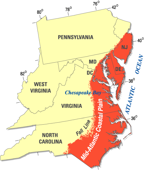
This report describes current research to relate geographic variables to water quality and aquatic ecology in small streams of the Mid-Atlantic Coastal Plain (fig. 1) (Pitchford and others, 2000). Base-flow water quality, sediment chemistry, benthic-community characteristics, and stream habitat (table 1) at approximately 200 small streams are being analyzed along with available geographic data to develop landscape-indicator models for ground-water contributions of pesticides and nutrients to streams and for stream condition. Project data also will be used to identify geologic and geochemical factors affecting water quality in the Mid-Atlantic Coastal Plain and to characterize the quality of water in headwater streams of the area during base-flow conditions in late winter and spring. The landscape-indicator models are being developed primarily by landscape ecologists at the USEPA; the USGS is evaluating hydrogeologic, geochemical, and land-use effects on stream-water quality in support of this effort.
 | |
Figure 1: Multi-scale network of stream-sampling sites in the Mid-Atlantic Coastal Plain. | |
The Mid-Atlantic Coastal Plain includes areas of the Coastal Plain Physiographic Province from North Carolina through New Jersey (fig. 1). The 114,000-km2 (square kilometer) area is mostly flat and low-lying, although some areas have considerable relief, particularly along the western margin at the Fall Line. The Coastal Plain is underlain by a wedge of unconsolidated sediments and (in North Carolina) carbonate rocks that vary texturally both laterally and vertically, and form an alternating series of aquifers and leaky confining units. The development of stream networks and ground-water resources in the Coastal Plain is controlled by this variable topography and sediment texture. Land use in the area is primarily forested (40 percent), agricultural (29 percent), or wetlands (including swamps; 23 percent) (Vogelmann and others, 1998).
During base-flow conditions, water in small streams of the Coastal Plain is derived from ground-water discharge, and stream-water quality reflects an integration of ground-water chemistry from throughout the stream watershed. Streamwater is derived from overland runoff during and following precipitation, and base flow, which is the discharge of ground water through the streambed. Streamflow is composed entirely of base flow during dry periods. For this reason, stream samples collected during base-flow conditions represent a mix of ground water from within the contributing watershed. Although water typically changes chemically as it discharges to the stream and is exposed to the atmosphere and aquatic organisms, samples collected during the cooler months of the year should be minimally affected by biologic nutrient uptake.
Table 1. Water, sediment, and ecological target analytes and measurements | |||||||
1ethanesulfonic acid |
2oxanilic acid |
3polychlorinated biphenyls |
4Ephemeroptera + Plecoptera + Trichoptera | ||||
Analytes and Measurements in Water |
Analytes in Sediment |
Ecological Measurements |
|||||
|
|
| |||||
Study Approach
A multi-scale network of stream-sampling sites has been established in the Mid-Atlantic Coastal Plain (fig. 1). Water-quality and biological data were collected synoptically (once during a short time span) in the late winter and spring of 2000 at each site. Data from the base network will be used to evaluate potential landscape-indicator models of pesticides and nutrients (including combinations of land-use patterns, hydrogeology, and soils), and to provide an assessment of water quality and stream biology in the study area. Additional sites were sampled to evaluate relatively pristine conditions and to determine how water quality and biology in small streams are related to downstream conditions.
Network Design
A base network of small streams (typically draining less than 10 km2) has been established in the Mid-Atlantic Coastal Plain. Twenty-five sites were randomly selected within each of seven distinct hydrogeologic subregions that were delineated on the basis of physiography and the bulk texture of surficial sediments (Ator and others, 2000). Alternative sites also were selected to provide replacements (as necessary) to ensure that approximately 25 sites were sampled in each subregion. Selection probabilities for each stream were adjusted (Stevens and Olsen, 1999) to provide an approximately uniform distribution of network sites along a gradient of forested to developed (agricultural or urban) land in the watershed. Streams at altitudes less than 2 meters were excluded to avoid tidal influence.
Additional sites were selected to provide supporting information for data from the base network. Six streams that drain relatively pristine watersheds were sampled as reference sites to characterize natural stream conditions and water quality. Periodic biological assessments have been conducted at these sites in the past. Sampling also was conducted in three sets of nested watersheds to show how results from first-order streams are related to downstream conditions. In addition, water samples were collected in two streams on a monthly or semi-monthly basis for approximately 1 year to place the base-network synoptic samples in the context of seasonal and annual hydrologic variability.
Data Collection
Biological assessments were conducted along a segment of each stream in the lower third of its watershed. Depth-integrated water samples were collected along a stream cross section at a point within this segment during base-flow conditions. Stream pH, dissolved-oxygen content, conductivity, discharge, and habitat condition were determined in the field. Water samples were analyzed for selected pesticides (including metabolites), nutrients, and major ions at USGS laboratories in Denver, Colorado and Lawrence, Kansas; sediment and biological samples were analyzed at USEPA laboratories (table 1). Variability and potential bias in water-quality data will be estimated on the basis of field blanks, field-matrix spikes, and replicates collected during sampling.
Data Analysis
Newly collected data will be analyzed along with existing data to develop landscape-indicator models for pesticides and nutrients in streams, and to provide an assessment of water quality in the Mid-Atlantic Coastal Plain. Topographic maps and digital elevation data will be used to delineate the contributing watershed for each sampled stream. Landscape metrics based on digital geographic data will also be used to characterize the distribution of land use, geology, soils, and other geographic variables within those watersheds. Landscape-indicator models will be developed through multiple regression and heuristic partitioning analyses to evaluate the success of various combinations of these geographic variables in explaining the variability in the water-quality and biological data. Regional water-quality and stream biological conditions will be estimated by considering collected data in light of the land-use bias built into the sampling network (see above).
References
Aspelin, A.R., 1997, Pesticide industry sales and usage -- 1994 and 1995 market estimates: U.S. Environmental Protection Agency 733-R-97-002, 35 p.
Ator, S.W., Denver, J.M., and Hancock, T.C., 2000, Relating shallow ground-water quality to surficial hydrogeology in the Mid-Atlantic Coastal Plain: Proceedings of the National Water-Quality Monitoring Conference, Austin, Texas, April 25-27, 2000, p. 409-423.
Briggs, S.A., 1992, Basic guide to pesticides -- their characteristics and hazards: Washington, D.C., Taylor and Francis, 283 p.
Jones, K.B., Riitters, K.H., Wickham, J.D., Tankersley, R.D.Jr., O'Neill, R.V., Chaloud, D.J., Smith, E.R., and Neale, A.C., 1997, An ecological assessment of the United States Mid-Atlantic Region: U.S. Environmental Protection Agency EPA/600/R-97/130.
Kepner, W.G., Jones, K.B., Chaloud, D.J., Wickham, J.D., Riitters, K.H., and ONeill, R.V., 1995, Mid-Atlantic landscape indicators project plan -- Environmental Monitoring and Assessment program: U.S. Environmental Protection Agency 620/R-95/003, 37 p.
Pitchford, A.M., Denver, J.M., Olson, A.R., Ator, S.W., Cormier, S., Nash, M.S., and Mehaffey, M.H., 2000, Testing landscape indicators for stream condition related to pesticides and nutrients -- Landscape Indicators for Pesticides Study for Mid-Atlantic Coastal Streams (LIPS-MACS): U.S. Environmental Protection Agency EPA/600/R-00/087, 84 p.
Stevens, D.L., and Olsen, A.R., 1999, Spatially-restricted surveys over time for aquatic resources: Journal of Agricultural, Biological, and Environmental Statistics, vol. 4, no. 4, p. 415-428.
Vogelmann, J.E., Sohl, T.L., Campbell, P.V., and Shaw, D.M., 1997, Regional land cover characterization using Landsat and ancillary sources: Environmental Monitoring and Assessment, 51: p. 415-428.
Editor: Valerie M. Gaine
Graphics and design: Timothy W. Auer
For further information contact:
District Chief
U.S. Geological Survey
8987 Yellow Brick Road
Baltimore, Maryland 21237
Branch Chief
Landscape Ecology Branch
U.S. Environmental Protection Agency
944 E. Harmon Avenue
Las Vegas, Nevada 89119
On the World Wide Web visit:
the USGS Maryland-Delaware-D.C. District Homepage at:
http://md.water.usgs.gov
or
the USEPA Landscape Sciences Homepage at:
http://www.epa.gov/nerlesd1/land-sci/home2.htm
USGS Fact Sheet FS-157-00
Maintainer:webmaster@md.usgs.gov

![]() U.S. Department of the Interior | U.S. Geological Survey
U.S. Department of the Interior | U.S. Geological Survey
Persistent URL: https://pubs.water.usgs.gov/fs15700
Page Contact Information: USGS Publishing Network
Page Last Modified: Tuesday, 29-Nov-2016 18:13:10 EST