Fact Sheet 057–01
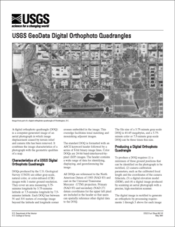
SummaryDOQs produced by the U.S. Geological Survey (USGS) are either gray-scale, natural color, or color-infrared (CIR) images with 1-meter ground resolution. They cover an area measuring 3.75minutes longitude by 3.75-minutes latitude or 7.5-minutes longitude by 7.5minutes latitude. Each DOQ has between 50 and 300 meters of overedge image beyond the latitude and longitude corner crosses embedded in the image. This overedge facilitates tonal matching and mosaicking adjacent images. |
First posted May 2001 Supersedes FS 039-99—No online version available Supersedes FS 129-95—No online version available Part or all of this report is presented in Portable Document Format (PDF); the latest version of Adobe Reader or similar software is required to view it. Download the latest version of Adobe Reader, free of charge. |
U.S. Geological Survey, 2001, USGS Digital Orthophoto Quadrangles: U.S. Geological Survey Fact Sheet 057–01, 2 p., available only online at https://pubs.usgs.gov/fs/2001/0057/.

![]() U.S. Department of the Interior |
U.S. Geological Survey
U.S. Department of the Interior |
U.S. Geological Survey
URL: http://
pubsdata.usgs.gov
/pubs/fs/2001/0057/index.html
Page Contact Information: USGS Publications Team
Page Last Modified: Tuesday, 29-Nov-2016 18:12:27 EST
