
Significant Items:
|
The storm front that moved across large parts of Indiana during the afternoon and evening of July 4, 2003, was more than a precursor to that night's Independence Day fireworks. The showers at first were seen by Hoosiers as a welcome source of moisture for lawns, gardens, and cropland. This storm, however, turned out to be the opening salvo of a 2-week onslaught of torrential rains that resulted in record-breaking floods in many basins. The heaviest rains were concentrated in north-central Indiana, July 5-10.
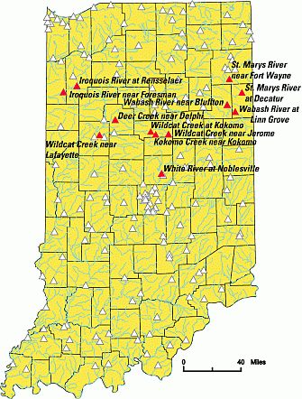
During the 2 weeks of downpours, water filled flood plains, overtopped roadways, and poured into homes. While flood waters ravaged Indiana communities, field crews from the U.S. Geological Survey (USGS) raced to gather vital hydrologic data. They measured the river flow and water levels to provide the information needed by river forecasters, engineers, and emergency managers who rely on data from the USGS network of about 170 Indiana streamflow-gaging stations (fig. 1). The network is funded in a cooperative program of federal, State, and local agencies, and is part of a national network maintained by the USGS. Many of these stations are equipped to transmit real-time streamflow data. In times of emergency, real-time streamflow information is a key element in the protection of lives and property. Real-time data are available to the public on the World Wide Web at
http://in.waterdata.usgs.gov/nwis/rt
|
| Figure 1. Map of U.S. Geological Survey streamflow-gaging stations in Indiana, 2003. Stations in red set new record-peak discharge or gage height in July 2003 flood. |
During the July 2003 floods, new records were set at 13 USGS streamflow-gaging stations in Indiana. The new peaks of record gage heights and new peaks of record discharges, along with other significant peaks, are listed in table1.
Discussion of the magnitude of the peaks follows.
Local news media reported nearly 10 inches of rain falling on the Kokomo area, July 4-5. The deluge flooded streets and backed up storm sewers. The runoff overwhelmed Kokomo Creek, a tributary to Wildcat Creek. The July 5 peak gage height at the gaging station Kokomo Creek near Kokomo (03333600) was 11.85 ft (feet), nearly 2 ft above the previous record set in 1964 (table 1). The peak discharge for the station was 2,950 ft3/s (cubic feet per second). This discharge was more than double the designated 100-year-flood discharge of 1,400 ft3/s. (A 100-year flood is that discharge for which there is a 1-percent chance of occurrence in any given year.) Coordinated flood frequencies for selected reaches of Indiana streams are available in the Indiana Department of Natural Resources online publication, Coordinated Discharges of Selected Streams in Indiana, at
http://www.state.in.us/dnr/water/surface_water/coordinated_discharges/
Upstream from Kokomo, Wildcat Creek near Jerome (03333450) peaked with a discharge in the range of a 30-year flood. Downstream from Kokomo, the peak discharge at Wildcat Creek at Owasco (03334000) was greater than a 100-year flood.
Table 1. Peaks for period of record and for July
2003 at selected U.S. Geological Survey streamflow-gaging stations in Indiana
[ft, foot; ft3/s, cubic foot per second;
--, no data; > , greater than; < , less than; S.O., stage-only gaging
station, beginning October 1, 2001; red, sites where new peak recorded July
2003; elevation of water surface can be obtained by adding the station datum
to the gage height]
| Station number | Station name | Station datum (ft) |
Period of record, in water yearsa |
Discharge peak of record (ft3/s) through 2002 water year |
Gage-height peak of record (ft) through 2002 water year |
Gage-height (ft) extreme outside period of record |
Date and time of peak in July 2003 |
Discharge peak (ft3/s) in July 2003 |
Gage-height peak (ft) in July 2003 |
Recurrence interval |
|---|---|---|---|---|---|---|---|---|---|---|
| 03322900 | Wabash River at Linn Grove, IN | 808.00 |
1965-2003 |
9,560 March 17, 1978 |
13.87 March 17, 1978 |
-- |
July 8 0500 |
14,500 |
14.76 |
>100 year |
| 03322985 | Wabash River near Bluffton, IN | 795.42 |
2002-2003 |
4,640 April 1, 2002 |
12.88 April 1, 2002 |
-- |
July 9 |
15,300 |
18.43 |
60 year |
| 03323500 | Wabash River at Huntington, IN | 700.04 |
1951-2003 |
S.O. |
23.20 February 10, 1959 |
22.7 March 1913 |
July 11 0600 |
Unknown |
19.37 |
-- |
| 03325000 | Wabash River at Wabash, IN | 642.66 |
1923-2003 |
49,600 May 18, 1943 |
24.44 February 11, 1959 |
28.7 March 26, 1913 |
July 7 1100 |
14,800d |
16.58d |
< 10 year |
| 03329000 | Wabash River at Logansport, IN | 573.28 |
1923-2003b |
89,800 May 18, 1943 |
21.32 May 18, 1943 |
25.3 March 26, 1913 |
July 7 1200 |
37,100 |
13.60 |
< 10 year |
| 03329700 | Deer Creek near Delphi, IN | 553.81 |
1944-2003 |
14,400 June 10, 1958 |
18.26 June 10, 1958 |
19.8 May 1943 |
July 5 2130 |
18,700d |
18.64 |
>100 yeard |
| 03331753 | Tippecanoe River at Winamac, IN | 674.19 |
2001-2003 |
4,600 May 16, 2002 |
11.48 May 16, 2002 |
-- |
July 11 0900 |
3,110 |
9.53 |
< 10 year |
| 03333050 | Tippecanoe River near Delphi, IN | 535.00 |
1939-2003b |
20,600 April 12, 1994 |
13.72 April 12, 1994 |
-- |
July 10 0800 |
18,500 |
12.80 |
10 year |
| 03333450 | Wildcat Creek near Jerome, IN | 820.04 |
1961-2003 |
7,120 July 14, 1992 |
13.71 December 30, 1990 |
18 March 1913 |
July 6 0015 |
7,160d |
14.35 |
30 year |
| 03333600 | Kokomo Creek near Kokomo, IN | 807.68 |
1959-2003 |
1,040 April 20, 1964 |
9.88 April 20, 1964 |
-- |
July 5 0630 |
2,950d |
11.85d |
>100 year |
| 03333700 | Wildcat Creek at Kokomo, IN | 775.62 |
1956-2003 |
8,100 February 10, 1959 |
16.95 December 30, 1990 |
-- |
July 5 1115 |
9,500d |
17.75 |
50 yeard |
| 03334000 | Wildcat Creek at Owasco, IN | 624.63 |
1944-1973, 1989-2003c |
10,800 January 4, 1980 |
13.30 January 5, 1950 |
-- |
July 6 0800 |
19,300 |
16.22 |
>100 year |
| 03335000 | Wildcat Creek near Lafayette, IN | 527.66 |
1954-2003 |
25,000 June 10, 1958 |
21.52 June 10, 1958 |
25.4 March 1913 |
July 7 0000 |
23,500 |
23.64 |
30 year |
| 03335500 | Wabash River at Lafayette, IN | 504.14 |
1924-2003b |
131,000 May 19, 1943 |
28.47 May 19, 1943 |
32.9 March 26, 1913 |
July 10 1800 |
80,000 |
25.05 |
30 year |
| 03336000 | Wabash River at Covington, IN | 473.97 |
1940-2003 |
147,000 May 20, 1943 |
32.44 May 20, 1943 |
35.1 March 1913 |
July 11 1000 |
89,000 |
28.90 |
30 year |
| 03340500 | Wabash River at Montezuma, IN | 457.75 |
1928-2003 |
184,000 May 20, 1943 |
32.83 May 20, 1943 |
34.0 March 27, 1913 |
July 12 0900 |
109,000d |
30.43d |
15 year |
| 03341500 | Wabash River at Terre Haute, IN | 445.78 |
1928-2003b |
189,000 May 20, 1943 |
30.50 May 20, 1943 |
31.2 March 27, 1913 |
July 13 1900 |
96,200d |
25.03d |
< 10 yeard |
| 03347000 | White River at Muncie, IN | 917.10 |
1931-2003 |
14,300 April 21, 1964 |
21.07 January 15, 1937 |
22.6 March 1913 |
July 10 1000 |
6,950 |
10.94 |
< 10 year |
| 03349000 | White River at Noblesville, IN | 738.16 |
1947-2003 |
27,000 December 31, 1990 |
21.31 April 22, 1964 |
-- |
July 10 1550 |
20,400 |
21.86 |
10 year |
| 03351000 | White River near Nora, IN | 710.94 |
1930-2003 |
32,400 May 19, 1943 |
19.19 January 1, 1991 |
22.4 March 26, 1913 |
July 11 0100 |
26,300d |
17.78 |
10 year |
| 03353000 | White River at Indianapolis, IN | 662.26 |
1930-2003b |
38,000 December 31, 1990 |
21.57 January 16, 1937 |
30.0 March 26, 1913 |
July 11 0300 |
27,900 |
17.19 |
< 10 year |
| 03354000 | White River near Centerton, IN | 595.44 |
1947-2003b |
50,500 April 22, 1964 |
18.38 December 31, 1990 |
22.8 March 1913 |
July 12 0600 |
37,800d |
17.01d |
< 10 year |
| 03360500 | White River at Newberry, IN | 465.59 |
1928-2003 |
105,000 November 18, 1993 |
25.87 November 18, 1993 |
27.5 March 27, 1913 |
July 15 2000 |
34,800 |
20.35 |
< 10 year |
| 03374000 | White River at Petersburg, IN | 400.00 |
1928-2003 |
183,000 January 22, 1937 |
28.30 January 22, 1937 |
29.5 March 1913 |
July 18 0400 |
48,800 |
20.97 |
< 10 year |
| 03377500 | Wabash River at Mount Carmel, IL | 369.46 |
1928-2003b |
305,000 May 25, 1943 |
32.35 May 17, 2002 |
33.0 March 30, 1913 |
July 20 0900 |
117,000 |
24.85 |
< 10 year |
| 04181500 | St. Marys River at Decatur, IN | 760.44 |
1947-2003 |
11,300 February 10, 1959 |
24.40 March 14, 1982 |
-- |
July 9 0800 |
15,000d |
26.92 |
> 100 year |
| 04182000 | St. Marys River near Fort Wayne, IN | 748.97 |
1931-2003 |
13,600 February 11, 1959 |
19.66 March 14, 1982 |
-- |
July 9 2300 |
16,000d |
21.20 |
100 year |
| 04183000 | Maumee River at New Haven, IN | 724.51 |
1957-2003b |
26,600 March 17, 1982 |
25.49 March 17, 1982 |
-- |
July 10 0900 |
19,400 |
21.57d |
< 10 year |
| 05521000 | Iroquois River at Rosebud, IN | 661.47 |
1948-2003 |
656 December 30, 1990 |
8.86 February 10, 1959 |
-- |
July 21 1615 |
475 |
6.30 |
100 year |
| 05522500 | Iroquois River at Rensselaer, IN | 642.29 |
1948-2003 |
2,550 June 10, 1958 |
16.54 June 10, 1958 |
-- |
July 10 1200 |
2,620d |
16.59d |
>100 yeard |
| 05524500 | Iroquois River near Foresman, IN | 624.00 |
1949-2003 |
5,930 June 14, 1958 |
24.42 June 14, 1958 |
-- |
July 11d |
5,350d |
24.87 |
Backwatere |
a Water year is the 12-month period October
1 through September 30. The 2003 water year, for example, includes October
1, 2002, through September 30, 2003.
b Fragmented periods of data exist for other years.
c The data include annual peaks for 1975-1981.
d Revised.
e Backwater is the condition when water is backed up or retarded
in its course, compared with its normal condition of flow.
The St. Marys River at Decatur gaging station (04181500) recorded the peak gage height on July 9 at more than 2.5 ft above the previous peak of record in March 1982. The discharge was greater than a 100-year flood. Even though the St. Marys River peaked at the St. Marys near Fort Wayne gaging station (04182000) at more than 1.5 ft above the 1982 flood level and the discharge was in the range of the 100-year flood, the city of Fort Wayne was spared a repeat of the 1982 devastation. In July 2003, the St. Joseph River, which flows from the north to join the St. Marys River to form the Maumee River, did not receive excessive amounts of precipitation. Consequently, the July 10 peak discharge at the Maumee River at New Haven gaging station (04183000) was less than a 10-year flood.
The July 8 crest at the Wabash River at Linn Grove gaging station (03322900) set new records. The peak gage height of 14.76 ft was almost 1 ft above the previous peak of record in March 1978. The peak discharge of 14,500 ft3/s was greater than a 100-year discharge.
The heavy rains generated a surge of water flowing down the upper reaches of the Wabash River, as indicated by the flows at Linn Grove. Much of this surge was captured in J. Edward Roush Lake in Huntington. The peak discharges on July 7 were less than a 10-year flood at Wabash River at Wabash (03325000) and Wabash River at Logansport (03329000), about 22 and 55 miles, respectively, downstream from the lake. Farther downstream, the Wabash River at Lafayette gaging station (03335500) peaked on July 10 with discharges in the 30-year-flood range. The Wabash River at Covington gaging station (03336000) peaked on July 11 with discharges also in the 30-year-flood range.
The peaks attenuated as the flows continued downstream. At the Wabash River at Montezuma gaging station (03340500), where local police assisted USGS field crews in launching their boat, the river peaked on July 12 with discharges in the 15-year-flood range. The Wabash River at Terre Haute gaging station (03341500) peaked on July 13 with discharge a little less than a 10-year-flood.
Although the initial surge of water from the upper reaches of the Wabash River Basin was captured by J. Edward Roush Lake, continued large flows into the lake required lake managers to release water when the lake's holding capacity had been exceeded. The stage-only gaging station, Wabash River at Huntington (03323500), just below the outflow structure of the lake, recorded a peak gage height of 19.37 ft on July 11. This was the highest water level since the peak of record, 23.20 ft, February 10, 1959, which was prior to construction of the reservoir.
The media reported loss of life in the Delphi area when high waters flooded homes and neighborhoods. At the Deer Creek near Delphi gaging station (03329700), the July 5 peak gage height of 18.64 ft exceeded the previous record peak of 18.26 ft, set in June 1958. The peak discharge of 18,700 ft3/s was greater than a 100-year flood.
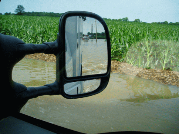
The Wabash River floods major roadways near the town of Bluffton, Indiana.

The Wabash River rises near
the town of Montezuma, Indiana.
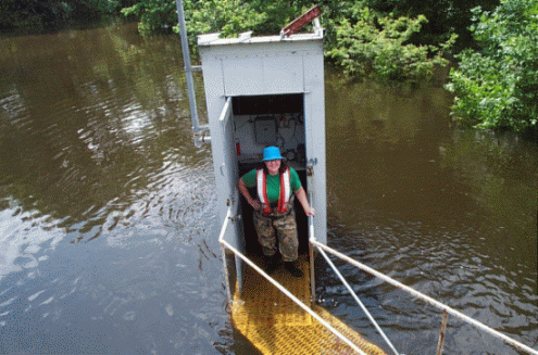
U.S. Geological Survey streamgager is shin deep in the Iroquois
River
as she inspects the gage near Foresman, Indiana.
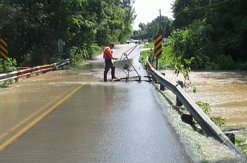
Kokomo
Creek flows over the bridge in the town of Kokomo, Indiana, as a
U.S. Geological Survey streamgager prepares to make a discharge
measurement.
In the Iroquois River Basin, on the western side of the State, peaks gained in magnitude as flows moved downstream. The July 9 discharge at the Iroquois River at Rosebud gaging station (05521000) was in the range of a 40-year flood. By the time the Iroquois River peaked at the Rensselaer gaging station (05522500) on July 10, discharges were greater than a 100-year-flood, eclipsing the June 1958 discharge. At the Iroquois River near Foresman gaging station (05524500), roads were submerged as water pooled up in the area faster than it could be drained, causing significant backwater conditions. Local citizens using large trucks, assisted USGS field crews by transporting them to the gaging station. The July 11 peak gage height at Foresman reached 24.87 ft, nearly one-half foot above the previous peak of record set in June 1958.
Intense rainfall several days later in the Wheatfield area caused the Iroquois River at Rosebud gaging station to peak on July 21 in the range of a 100-year- flood discharge. The effects of that later storm, however, seemed to lessen as the flow moved to the downstream stations.
In parts of Marion and Hamilton Counties, large tracts of land along with homes and businesses were inundate by White River flood waters. At the White River at Muncie gaging station (03347000), the July 10 peak discharge was less than a 10-year flood. Downstream, peak discharges at White River at Noblesville (03349000) and White River near Nora (03351000) gaging stations were in the 10-year-flood range. Farther downstream, the peak discharges diminished to less than a 10-year flood.
At the White River at Noblesville gaging station, a new record gage height was reached, even though the discharge was in the range of a 10-year flood. The previous peak-of-record gage height was on April 22, 1964, when the gage height reached 21.31 ft, with a discharge of 26,800 ft3/s. The peak-of-record discharge, 27,000 ft3/s, was on December 31, 1990, when the gage height reached 21.29 ft. On July 10, 2003, the stream peaked at a discharge of 20,400 ft3/s, with a new record gage height of 21.86 ft. Even though the peak discharge for the most recent flood was about 24 percent less than the two previous record peaks, the gage height crested about one-half foot higher.
The July 2003 flood was notable not only in the magnitude of the peaks but also in the number of separate basins affected. By the end of July, the Federal Emergency Management Agency (http://www.fema.gov) listed 40 Indiana counties as declared disaster areas. Although the destruction caused by the flooding was significant, the geographic patterns of the precipitation resulted in the dispersal of large volumes of water, thus averting a concentration of the runoff toward a single receiving stream. The flood waters of the Iroquois River drained west toward the Illinois River, and the flood waters on the St. Marys River drained east into Ohio by way of the Maumee River. The upper Wabash River and upper White River drained south, with the peaks attenuating as they moved downstream into areas where there had been less rainfall.
This report is presented in Portable Document Format (PDF) ( 264KB).
Go to the USGS Indiana District Reports And Fact Sheets On Line web page.
Go to the USGS Indiana District Home Page.
| AccessibilityFOIAPrivacyPolicies and Notices | |
 |
|