EARTHQUAKE
DETECTIVE WORK REVEALS PREVIOUSLY UNKNOWN HAZARDS


USGS
SHAKING-HAZARD MAPS

|
EARTHQUAKE
DETECTIVE WORK REVEALS PREVIOUSLY UNKNOWN HAZARDS
|
|
 |
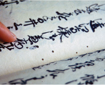
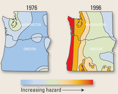
In the 1980’s, U.S. Geological Survey (USGS) scientists discovered the first evidence that very large earthquakes have repeatedly struck the Pacific Northwest in the past. Geologic and tree-ring studies showed that a strong earthquake of unknown magnitude struck the region in about 1700, a century before the Lewis and Clark expedition. Trees (left) died when coastal areas were lowered during the quake, submerging their roots in saltwater. In the 1990’s, clues to this quake’s magnitude were found by USGS and Japanese researchers in 300-year-old administrative records from Japan (lower left). Those records describe the effects of a destructive tsunami (seismic sea wave) that occurred without the usual warning of a nearby earthquake. The scientists pieced these and other clues together and determined that only an extraordinarily powerful earthquake from across the Pacific Ocean could have generated this tsunami. They concluded that a quake of magnitude 9 struck the Pacific Northwest on the evening of January 26, 1700, releasing 30 times as much energy as the largest quake ever recorded in California. When this potential for magnitude 9 earthquakes offshore Washington and Oregon was recognized, USGS and the Federal Emergency Management Agency (FEMA) helped to form the Cascadia Region Earthquake Workgroup (CREW), which has involved Federal and local government officials with business and industrial interests to jointly and effectively address earthquake hazards and promote mitigation in the Pacific Northwest. USGS earthquake-hazard maps (below) that are used to set building codes were also revised to reflect the recently identified hazard in the Pacific Northwest. |
 |
|
|
USGS
SHAKING-HAZARD MAPS
|
|
 |
|