DISCOVERING
HIDDEN FAULTS


|
DISCOVERING
HIDDEN FAULTS
|
|
 |
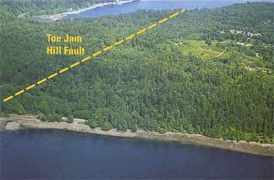
Discovering active faults in thickly vegetated regions, such as the Puget Sound area of Washington (photo), is very challenging because their topographic expressions are hard to see. However, a new airborne laser technology, called LIDAR (light detection and ranging), is fast changing this. LIDAR imaging can see through forests to permit high-resolution measurement of topography to a precision of a foot or less, showing otherwise invisible faults. Using LIDAR, the U.S. Geological Survey has been able to identify previously unknown faults in the Seattle and Puget Sound area. The LIDAR image at right reveals the Toe Jam Hill Fault, marked by a conspicuous east-west topographic trend (arrows). In addition, the image shows north-south grooves in the Earth’s surface that were formed by the movement of ancient glaciers. |
 |
|