
Fact Sheet 2004–3011
March 2004
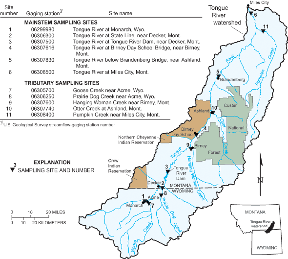
Figure 1. Water-quality sampling sites in the Tongue River watershed. All s...
Figure 2. The sodium adsorption ratio (SAR) commonly can be estimated from ...
Coal-bed methane (CBM) development is in the initial stages of exploration and production in the Tongue River watershed of southeastern Montana and northeastern Wyoming (fig. 1). In recent years, many State, Federal, and Tribal agencies and other entities have worked together to share information, communicate concerns, and coordinate data-collection activities for areas of potential CBM development. While past and ongoing efforts have added substantially to our scientific understanding, sufficient monitoring data are not available for full documentation of water resources and water quality in the watershed. As CBM development proceeds over the next 10 to 20 years, long-term monitoring will be needed to provide information to evaluate any changes or trends in surface-water quality and support informed decisions about resource management. For fiscal year 2004, Congress appropriated funding for the U.S. Geological Survey to initiate a comprehensive surface-water-quality monitoring program in the Tongue River watershed. The goal of the program is to collect and disseminate water-quality data to stakeholders and the general public as well as to State and Federal agencies tasked with managing and regulating CBM development.
The objectives of this monitoring program are to:
Establish monitoring network. A monitoring network consisting of eleven stations will be established during 2004 (fig. 1). Six mainstem monitoring stations will be on the Tongue River to identify downstream changes in water quality. Five stations will be on major tributaries to the Tongue River to document water quality in these smaller watersheds. Continuous streamflow and specific-conductance data will be collected at each station.
Collect water-quality data. The mainstem Tongue River stations will be sampled approximately twice-monthly during the irrigation season (March-October) and once-monthly for the rest of the year. The tributary stations will be sampled approximately 12 times per year, with more frequent sampling during the irrigation season. Water samples will be analyzed for major ions, nutrients, trace elements, and suspended sediment. Constituents of primary concern for analysis are those typically contained in CBM product water at relatively high concentrations. Examples of these constituents include sodium (a major ion), ammonia (a nutrient), and nitrate (another nutrient that forms when ammonia is exposed to oxygen). Trace elements, such as arsenic, iron, manganese, and nickel, are of lesser concern because their concentrations generally are relatively low (Rice and Nuccio, 2000).
Develop real-time SAR estimates and measurement techniques. Providing real-time SAR information will be addressed in two ways. First, statistical relations between specific conductance and SAR will be examined for each station (fig. 2). If these relations are statistically meaningful, real-time estimates of SAR will be generated from continuous specific- conductance data for each station. Second, recent technological advances have made possible the development of experimental instrumentation that can be placed in the field and provide automated measurements of the constituents (calcium, magnesium, and sodium) which are used to calculate SAR. One analyzer will be built, deployed, and tested during 2004. If that is successful, a second instrument will be deployed in 2005.
Sodium adsorption ratio (SAR) is a measure of the suitability of irrigation water for sustained soil and crop health. Water with a higher ratio is less suitable for irrigation. SAR values greater than 5-10 can indicate medium to high sodium hazard.
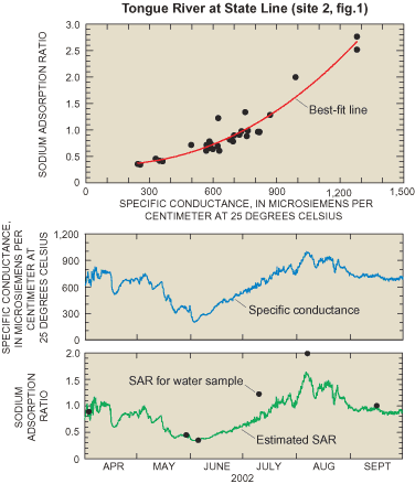
Tongue River at State Line, Montana (site 2, fig. 1).
Provide information to the public. All data collected at each station in the network will be made available on a dedicated web site developed just for this network: (http://TongueRiverMonitoring.cr.usgs.gov/). Streamflow and specific-conductance data will be provided in real time from satellite transmissions. Estimates of SAR at stations with sufficient data and reliable statistical relations also will be provided on the dedicated web site. Should the experimental SAR instrumentation prove successful, then SAR values calculated from direct field measurements of calcium, magnesium, and sodium will also be provided.
Rice, C.A., and Nuccio, Vito, 2000, Water produced with coal-bed methane: U.S. Geological Survey Fact Sheet FS-156-00, 2 p.
District Chief
U.S. Geological Survey
3162 Bozeman Avenue
Helena, MT 59601
406-457-5900
The USGS Montana District homepage is: http://mt.water.usgs.gov/
The USGS Tongue River monitoring program homepage is: http://TongueRiverMonitoring.cr.usgs.gov/
The National USGS homepage is: http://www.usgs.gov/
Document Accessibility: Adobe Systems Incorporated has information about PDFs and the visually impaired. This information provides tools to help make PDF files accessible. These tools convert Adobe PDF documents into HTML or ASCII text, which then can be read by a number of common screen-reading programs that synthesize text as audible speech. In addition, an accessible version of Acrobat Reader 6.0, which contains support for screen readers, is available. These tools and the accessible reader may be obtained free from Adobe at Adobe Access.
| AccessibilityFOIAPrivacyPolicies and Notices | |
 |
|