Ground-Water Age and Flow at Great
Sand Dunes
National Monument, South-Central Colorado
Fact Sheet 2004–3051
By Michael G. Rupert and L. Niel Plummer
Available from the U.S. Geological Survey,
Branch of Information Services, Box 25286,
Denver Federal Center, Denver, CO 80225, USGS Fact Sheet 2004-3051.
(Requires Adobe Acrobat Reader)
|
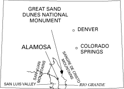
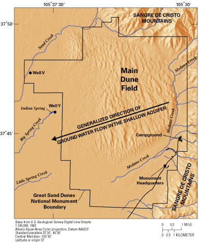
Great Sand Dunes National Monument (hereinafter called Great Sand Dunes) is located in south-central Colorado along the eastern edge of the San Luis Valley (fig. 1). The San Luis Valley is bounded by the Sangre de Cristo Mountains to the east and the San Juan Mountains to the west. Great Sand Dunes has an altitude ranging from about 7,500 to 10,300 feet and receives annual average precipitation of about 11 inches near the Great Sand Dunes Headquarters (fig. 2).
The predominant feature in Great Sand Dunes is the 30 square-mile
main dune field (fig. 2) which rises up to 750 feet above the valley
floor. The age of the dunes is estimated to be between 2,000 and
12,000 years old (Chatman and others, 1997). Composition of the
sand indicates the predominant source is the San Juan Mountains
to the west. The sand was transported to the San Luis Valley by
the Rio Grande and other local streams and then carried by prevailing
southwesterly winds to the Sangre de Cristo Mountain front. The
shape of the Sangre de Cristo Mountains acts as a sand trap
(Chatman and others, 1997).
Ground water near Medano and Sand Creeks probably is only a few years old. The ground water then travels in a southwesterly direction, underneath the main dune field. Additional water from precipitation on the dune field moves down to and mixes with the ground water underneath the main dune field. Ground water in the shallow aquifer also travels to springs that discharge to Big and Little Spring Creeks on the west side of Great Sand Dunes. Ground-water age dating using chlorofluorocarbons (FreonTM) and tritium (an isotope of hydrogen) indicate that it takes more than 60 years for ground water to travel underneath the dune field from Medano and Sand Creeks to Big and Little Spring Creeks (Rupert and Plummer, 2004). How Old is Water in the Deep Aquifer? Using carbon-14 geochemical dating methods, the age of ground water sampled from well Y, which is completed in the deep aquifer and is near the western edge of the dune field (fig. 2), is about 30,000 years before present (plus or minus 3,000 years) (Rupert and Plummer, 2004). This age was determined using methods similar to those used to date charcoal found in firepits of archeological sites. The last major ice advance (Wisconsin) during the ice age peaked about 20,000 years before present (U.S. Geological Survey, 1992); ground water from the deep aquifer is older than that. References Chatman, M., Sharrow, D., and Valdez, A., 1997, Water resources management plan, Great Sand Dunes National Monument, Colorado: National Park Service, Water Resources Division, 197 p. Rupert, M.G., and Plummer, L.N., 2004, Ground-water flow direction, water quality, recharge sources, and age, Great Sand Dunes National Monument and Preserve, south-central Colorado, 2000-2001: U.S. Geological Survey Scientific Investigations Report 2004-5027, 32 p. U.S. Geological Survey, 1992, The great ice age: U.S. Geological Survey General Interest Publication, ISBN 0-16-036025-0, 8 p. Accessed May 29, 2002, at URL https://pubs.usgs.gov/gip/ice_age/
|