
The surface-water resources of Hawaii have significant cultural, aesthetic, ecologic, and economic importance. In Hawaii, surface-water resources are developed for both offstream uses (for example, drinking water, agriculture, and industrial uses) and instream uses (for example, maintenance of habitat and ecosystems, recreational activities, aesthetic values, maintenance of water quality, conveyance of irrigation and domestic water supplies, and protection of traditional and customary Hawaiian rights). Possible long-term trends in streamflow characteristics have important implications for water users, water suppliers, resource managers, and citizens in the State.
Proper management of Hawaii's streams requires an understanding of long-term trends in streamflow characteristics and their potential implications. Effects of long-term downward trends in low flows in streams include potential loss of habitat for native stream fauna and reduced water availability for offstream and instream water uses. Effects of long-term upward trends in high flows in streams include construction of bridges and water-conveyance structures that are potentially unsafe if they are not designed with proper consideration of trends in high flows.
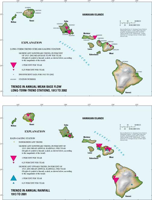
The network of long-term-trend stations in Hawaii consists of 16 active stations; seven of the 16 active stations have sufficient data for analysis of trends during 1913-2002, 14 have sufficient data during 1953-2002, and 16 have sufficient data during 1973-2002. In Hawaii, a total of 20 stream-gaging stations (four on Kauai, five on Oahu, two on Molokai, five on Maui, and four on the island of Hawaii) were identified as long-term-trend stations using two criteria: (1) drainage basins upstream of the stations were free of artificial changes, and (2) stations were located in a variety of settings with different physical and climatological characteristics (Fontaine, 1996). Only 16 (four on Kauai, five on Oahu, one on Molokai, four on Maui, and two on the island of Hawaii) of the 20 stations are currently (2004) active.
The U.S. Geological Survey has collected high-quality data from continuous-record stream-gaging stations since the early part of the 20th century in Hawaii. Long-term data collection is essential for the understanding and management of surface-water resources of the State. In Hawaii, cooperative funding for the U.S. Geological Survey network of surface-water stations currently is being provided by the State Commission on Water Resource Management, State Department of Transportation, U.S. Army Corps of Engineers, Honolulu Board of Water Supply, Maui and Hawaii County Departments of Water Supply, and others.
Daily mean discharge data collected by the U.S. Geological Survey at seven long-term-trend stations were used to evaluate trends in annual flow characteristics in Hawaii from 1913 to 2002. Only water years with complete data were considered. Annual total streamflow and estimated base flow were computed for each water year. Total streamflow includes both base flow and direct runoff associated with storms. Base flow, which is maintained by ground-water discharge to streams, represents the sustained low flow of streams during periods of no rainfall. Base flow can be estimated from the total-streamflow record using computerized base-flow separation methods (see for example Oki, 2003).
Rainfall controls both total flow and base flow in streams. Rainfall data through 1986 were obtained from the Hawaii Commission on Water Resource Management (CWRM), and these data were updated through 2001 using data from the National Climatic Data Center (2002). Data from 70 rain-gaging stations were used to evaluate trends in annual rainfall from 1913 to 2001.
Annual flows and annual rainfall were statistically analyzed for long-term trends using the Mann-Kendall test (Hirsch and Slack, 1984) that was modified to account for 1-year serial correlation (Oki, in press). The Kendall-Theil robust line (Helsel and Hirsch, 1992) was used to estimate the slope of linear trends in annual flows and rainfall. For this study, a 5-percent level of significance was selected to indicate the presence of statistically significant trends.
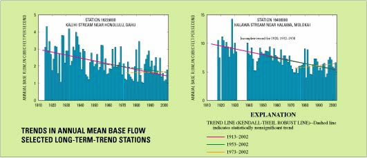
Annual base and total flows at seven long-term stations were analyzed for trends during 1913-2002. The records for all seven stations were complete for at least 80 percent of the years during 1913-2002. Analysis of trends in base flow (ground-water discharge to streams) provides insight related to changes in ground-water storage, whereas analysis of trends in total flow (base flow plus direct runoff) provides insight related to changes in actual flow in the stream as well as changes in high flow.
Statistically significant downward trends in annual base flow during 1913-2002 were detected at all seven stations. Long-term downward trends in base flow are consistent with long-term downward trends in rainfall over much of the State during this period. Thus, the downward trends in base flow at the long-term-trend stations may be representative of many other streams throughout the State as well. For more recent periods, such as 1953-2002 and 1973-2002, significant trends in base flow generally were not detected at the long-term-trend stations (Oki, in press). For the period 1953-2002, a significant downward trend in base flow was detected at only one of 14 long-term-trend stations (16400000 on Molokai), and for the period 1973-2002, a significant downward trend was detected at only one of 16 stations (16019000 on Kauai). Detection of trends in base flow may be highly dependent on the period being considered. The downward trends detected during 1913-2002 may reflect higher than average base flows prior to the 1940s, followed by a period after the 1940s during which base flows did not trend significantly upward or downward.
A statistically significant downward trend in annual total streamflow (base flow plus direct runoff) during 1913-2002 was detected at only one of the seven long-term-trend stations (16229000 on Oahu). For more recent periods, such as 1953-2002 and 1973-2002, significant trends in total streamflow generally were not detected at the long-term-trend stations (Oki, in press). For the period 1953-2002, a significant downward trend in total streamflow was detected at only one of 14 long-term-trend stations (16211600 on Oahu), and for the period 1973-2002, no significant trends in total streamflow were detected at 16 long-term-trend stations.
For the statistical trend test used in this study, a 5-percent level of significance was selected. The 5-percent level of significance indicates that a 5-percent chance for error exists in concluding that a trend is statistically significant when in fact no trend exists.
Additional information on trends and variations in streamflow in Hawaii and regional factors (including El-Niño) that are related to the observed trends and variations is available in the U.S. Geological Survey publication, "Trends in Streamflow Characteristics at Long-Term Gaging Stations, Hawaii", by Delwyn S. Oki (see reference list for complete citation).
Long-term downward trends in base flow of streams correspond to downward trends in rainfall and may reflect a decline in ground-water storage and recharge. Because ground water provides about 99 percent of Hawaii's domestic drinking water (Gingerich and Oki, 2000), a reduction in ground-water storage and recharge has serious implications for drinking-water availability. In addition, reduction in stream base flows may reduce habitat availability for native stream fauna and water availability for both instream and offstream uses, particularly during periods of little or no rainfall.
Long-term downward trends in total flow (base flow plus direct runoff) of streams are much less widespread than trends in base flow, which reflects differences between direct-runoff and base-flow characteristics. Whereas base-flow trends generally were downward, direct runoff likely did not change significantly over time, resulting in a general lack of long-term trends in total flow.
Further study is needed to determine (1) whether the downward trends in base flows from 1913 to 2002 will continue or whether the observed pattern is part of a long-term cycle in which base flows may eventually return to higher levels measured during 1913 to the early 1940s, (2) the physical causes for the detected trends and variations in streamflow, and (3) whether regional climate indicators successfully can be used to predict streamflow trends and variations throughout the State. These needs for future study underscore the importance of maintaining and expanding the existing network of long-term-trend stream- gaging stations in Hawaii.

Since 1909, the U.S. Geological Survey has operated a total of about 500 stream-gaging stations on selected streams throughout Hawaii. Although many of these stations record only peak water levels during storms, a significant number of stations continuously monitor stream stage (water level) and flow. The number of active continuous-record stations in Hawaii peaked near 200 stations in the 1960s and has declined greatly since then. Currently (2004), the number of active continuous-record stations in Hawaii is 69, close to the number of stations maintained in 1913. The reduced number of continuous-record stations in Hawaii will diminish the ability of water managers and users to understand and properly manage the State's surface-water resources.
Fontaine, R.A., 1996, Evaluation of the surface-water quantity, surface-water quality, and rainfall data-collection programs in Hawaii, 1994: U.S. Geological Survey Water-Resources Investigations Report 95-4212, 125 p.
Gingerich, S.B., and Oki, D.S., 2000, Ground water in Hawaii: U.S. Geological Survey FS-126-00, 6 p.
Helsel, D.R., and Hirsch, R.M., 1992, Statistical methods in water resources: Amsterdam, The Netherlands, Elsevier, 522 p.
Hirsch, R.M., and Slack, J.R., 1984, A nonparametric trend test for seasonal data with serial dependence: Water Resources Research, v. 20, no. 6, p. 727-732.
National Climatic Data Center, 2002, Cooperative summary of the day TD3200, period of record through 2001 data, western United States and Pacific Islands, released November 2002, National Oceanic and Atmospheric Administration, CD-ROM.
Oki, D.S., in press, Trends in streamflow characteristics at long-term gaging stations, Hawaii: U.S. Geological Survey Scientific Investigations Report 2004-5080.Oki, D.S., 2003, Surface water in Hawaii: U.S. Geological Survey FS-045-03, 6 p.
For sale by
U.S. Geological Survey,
Information Services
Box 25286, Denver Federal Center
Denver, CO 80225
For more information about the USGS and its products:
Telephone: 1-888-ASK-USGS
World Wide Web: http://www.usgs.gov/
For more information about USGS activities in Hawaii, visit the USGS Hawaii District home page.
Any use of trade, product, or firm names in this publication is for descriptive purposes only and does not imply endorsement by the U.S. Government.Although this report is in the public domain, permission must be secured from the individual copyright owners to reproduce any copyrighted materials contained within this report.
Suggested citation:
Citation: Oki, D.S., 2004, Trends in Streamflow Characteristics in Hawaii, 1913-2003: U.S. Geological Survey Fact Sheet 2004-3104, 4 p.
This report is available online in Portable Document Format (PDF). If you do not have the Adobe Acrobat PDF Reader, it is available for free download from Adobe Systems Incorporated.
Download the text of the report (PDF, 4.4 MB
Document Accessibility: Adobe Systems Incorporated has information about PDFs and the visually impaired. This information provides tools to help make PDF files accessible. These tools convert Adobe PDF documents into HTML or ASCII text, which then can be read by a number of common screen-reading programs that synthesize text as audible speech. In addition, an accessible version of Acrobat Reader 5.0 for Windows (English only), which contains support for screen readers, is available. These tools and the accessible reader may be obtained free from Adobe at Adobe Access.
For more information about USGS activities in Hawaii, visit the USGS Hawaii District home page.
| AccessibilityFOIAPrivacyPolicies and Notices | |
 |
|