
Changing Salinity Patterns in Biscayne Bay, Florida
Introduction
Biscayne Bay, Fla., is a 428-square-mile (1,109-square-kilometer) subtropical estuarine ecosystem that includes Biscayne National Park, the largest marine park in the U.S. national park system (fig. 1). The bay began forming between 5,000 and 3,000 years ago as sea level rose and southern Florida was flooded. Throughout most of its history, the pristine waters of the bay supported abundant and diverse fauna and flora, and the bay was a nursery for the adjacent coral-reef and marine ecosystems.
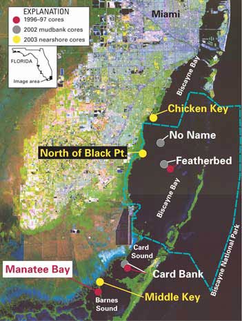 |
Figure 1. Satellite image map of Biscayne Bay, Fla., showing sites where USGS cores were collected and the boundary of Biscayne National Park (blue dashed line). Image cropped from John W. Jones, Jean-Claude Thomas, and Gregory B. Desmond, 2001, South Florida Everglades satellite image map: USGS Miscellaneous Investigations Series Map I–2742; see http://sofia.usgs.gov/projects/remote_sens/sflsatmap.html. |
In the 20th century, urbanization of the Miami-Dade County area profoundly affected the environment of the bay. Construction of powerplants, water-treatment plants, and solid-waste sites and large-scale development along the shoreline stressed the ecosystem. Biscayne National Monument was established in 1968 to “preserve and protect for the education, inspiration, recreation and enjoyment of present and future generations a rare combination of terrestrial, marine, and amphibious life in a tropical setting of great natural beauty” (Public Law 90–606). The monument was enlarged in 1980 and designated a national park.
Water Control—An Altered System
As the population of South Florida grew during the 20th century, demands increased for protection from seasonal flooding and for water for human consumption and for agriculture. These demands led to the construction of extensive water-control structures throughout South Florida, most notably by the Central and Southern Florida (C&SF ) Project. The C&SF Project, authorized by Congress in 1948, altered the seasonal delivery of freshwater and thus affected the wetlands, estuaries, and coastal environments of South Florida, including Biscayne Bay.
During the 1980s and 1990s, momentum built for restoration of more natural flows to the fragile environments of South Florida, leading to the approval of the Comprehensive Everglades Restoration Plan (CERP) as part of the Water Resources Development Act of 2000. The primary goal of the CERP is to restore the timing, quantity, quality, and distribution of freshwater so that the ecosystem conditions approximate predevelopment conditions as closely as possible.
Objectives
Before restoration can occur, baseline conditions of the environment prior to significant human alteration must be established, and the range of variation within the natural system must be determined. Natural ecosystems evolve over time, and so it is important to understand what portion of present-day change is due to human activity and what portion is due to natural variations. For example, what role has climate change or sea-level rise played in shaping Biscayne Bay as it exists today?
Research for the U.S. Geological Survey’s (USGS) Ecosystem History of Biscayne Bay Project has two objectives—to examine historical changes in the ecosystem at selected sites on a decadal to centennial scale and to correlate these changes with natural events and anthropogenic alterations in the South Florida region. Emphasis is placed on historical changes to amount, timing, and sources of freshwater influx and the resulting effects on salinity and water quality. By reconstructing the patterns of change prior to significant alteration of the environment, we can predict what the environment would have looked like without human alteration and can estimate what portion of change may be related to human activity. The results of this work are providing restoration planners with information on the predevelopment conditions of Biscayne Bay and will allow them to set realistic targets for restoration.
Uncovering the History of an Ecosystem
The history of an ecosystem is recorded in the sedimentary record—the sediments themselves and the faunal and floral remains in those sediments. Retrieving historical information recorded in sediments follows basic principles of geology (primarily the law of superposition and the principle of uniformity, that is, the present is the key to the past) and utilizes many paleoecological and geochemical tools.
USGS cores are collected from areas within a South Florida ecosystem that have sufficient sediment thickness and as little bioturbation (digging and burrowing by animals), storm disruption, and erosion as possible. The cores are then X-rayed (fig. 2), described, and cut into 0.4- to 2-inch-thick (1- to 5-centimeter-thick) samples. Age models are developed for the cores by using radiogenic isotopes of lead and carbon. Additional information on sample ages comes from the first occurrence of Australian pine pollen (Casuarina) in a core. Australian pine is an exotic species introduced to South Florida around the beginning of the 20th century, and it provides an excellent stratigraphic marker for the early 1900s.
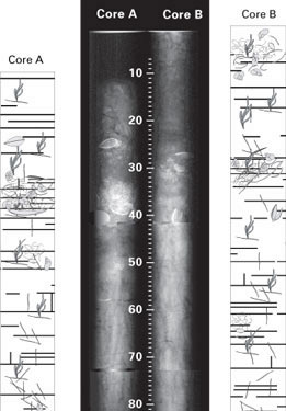 |
Figure 2. X-radiographs and schematic sections of the top 80 cm of USGS cores
collected from Featherbed Bank, Biscayne Bay, Fla., in 2002. Scale is in
centimeters. X-radiographs were done compliments of Mariners Hospital,
Tavernier, Fla. Schematic drawings show occurrence of laminations and remains
of plants and shells. |
In order to determine past changes in salinity, the core samples undergo analyses for plant and animal assemblages and for shell biochemistry. The key to both types of analyses is to study and understand the ecology of the living organisms in South Florida. Figure 3 illustrates how this process works for assemblage analyses. If we understand how and under what conditions a plant or animal lives today, then we can extrapolate that information to interpret past environments. Studies of living animals and plants in the estuaries of South Florida have been conducted since 1995. Part of this modern dataset includes information on salinity preferences of animals, which we assume remain consistent over time. Thus, when we find remains of animals in our core samples that are the same animals studied in the modern environment, we can estimate the range of salinity that existed when they were alive.
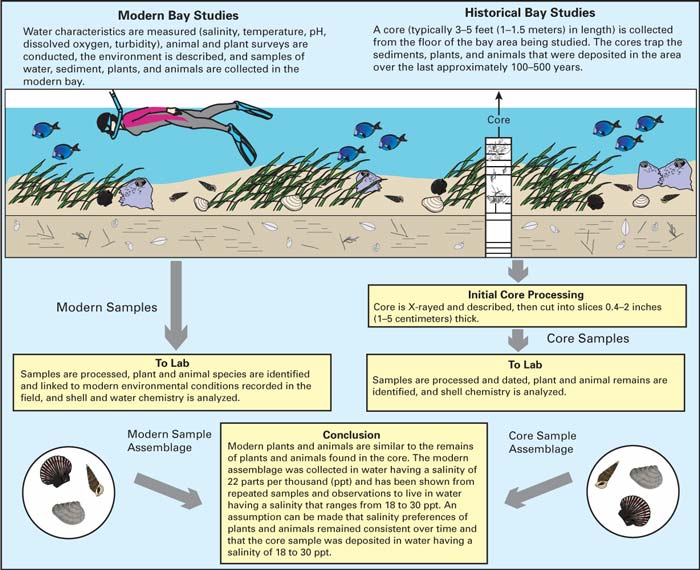 |
| Figure 3. Diagram showing how information on modern conditions is used to interpret
the historical environmental conditions from the remains of plants and
animals found in cores collected from the study area. |
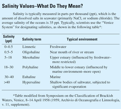
The biochemical analyses work in much the same way. Organisms having calcareous (CaCO3) skeletons record information about the water in which they secrete their skeletons. The metal/calcium ratios of shells from microscopic invertebrates (ostracodes) have been calibrated to salinity in the modern environment, and so these ratios can be calculated for ostracodes from core samples and a salinity value derived. (See box for an explanation of salinity values.)
 |
The results of the assemblage analyses are plotted as the percent abundance of key indicator groups in each sample in the core (figs. 4 and 5). These plots give a picture of the changes throughout the time of deposition of the core. By examining a number of different indicators from each core, we increase our confidence in our interpretations, and we provide a more detailed description of what the past environment was like.
 |
 |
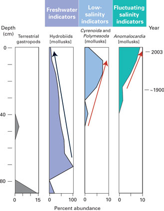
| Figure 4. Key molluscan salinity indicators in Middle Key core from nearshore
area of Barnes Sound. Percent abundances of indicator species in core segments
are plotted against depth (in centimeters) on the left and approximate
calendar year on the right. Red arrows track increased numbers of estuarine
species. Black arrow shows decreasing influx of freshwater species. Combined
the indicators show a steady increase in salinity upwards in the core and
decreasing influx from freshwater and terrestrial environments. |
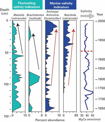
Figure 5. Key salinity indicators in No Name Bank core from central Biscayne
Bay. Percent abundances of indicator species in core segments and magnesium/calcium
(Mg/Ca) ratios derived from ostracode shells are plotted against depth
(in centimeters) on the left and calendar year on the right. Red arrows
track increased numbers of marine species, indicating increasingly marine
and increasingly stable salinity. Black arrows highlight decreasing numbers
of species that thrive in fluctuating salinity. Red dashed line shows a
shift in the Mg/Ca ratio of ostracode shells (a proxy for salinity) from
more fluctuating salinity to more stable salinity in the upper part of
the core. |
Changes in Biscayne Bay Salinity
Cores from nine sites in Biscayne Bay (fig. 1) have been analyzed. These analyses are described in the reports listed in the references box. The results indicate that the Biscayne Bay ecosystem has undergone many significant changes over the last 100 to 500 years.
Southern Biscayne Bay, including Card Sound and Barnes Sound, has been relatively isolated from direct marine influence for at least the last two centuries due to its enclosed configuration (see fig. 1). Currently, this area is less influenced by the urbanization that has taken place to the north, and there are few developed areas along the shoreline. Despite this relative isolation, the area has undergone distinctive changes during the last century. The three sites examined (Card Bank, Middle Key basin, and Manatee Bay) all show increasing salinity during the last 100 years. At Card Bank, the salinity historically has shown rather large variations on multidecadal and centennial time scales relative to those seen at central Biscayne Bay sites, but marine influence at Card Bank has increased over the last century. The salinity of Middle Key basin has increased steadily since before 1900 (fig. 4).
The mudbanks of central Biscayne Bay have become increasingly marine and increasingly stable (less fluctuation in salinity) during the last 100 years (fig. 5). No indications of interdecadal salinity extremes or periods of hypersalinity have been found in cores from Featherbed and No Name Banks. The salinity has ranged from estuarine to marine (polyhaline to euhaline; see box) throughout the period recorded in the sediment cores.
The nearshore cores from north of Black Point and Chicken Key have a history of fluctuating salinity. At both sites, the oldest sediments with faunal remains show deposition under conditions of slightly elevated (mesohaline to polyhaline) salinity relative to the overlying layers, succeeded by a period of lower (mesohaline) salinity. In the last 20 to 30 years, salinity at both sites has increased to polyhaline conditions, and there is evidence of an increase in salinity fluctuations during the same time period.
Implications for Restoration
One overwhelming trend emerges from the analyses of all the cores examined—increasing salinity in the Biscayne Bay system. Although the timing of the onset of increased salinity varies at the different core sites, there are no exceptions to this trend. In the nearshore sites, the increase in average salinity has been accompanied by an increase in variability of salinity. In contrast, the central Biscayne Bay sites have shown increasingly stable salinity over the last century and indications of increasing marine influence. These trends could be a result of rising sea level, of changes to the natural flow of freshwater, or both, but the timing of changes at some of the nearshore sites suggests that both factors are involved.
These results have significant implications for restoration planning. First, sea-level rise and the recognition that Biscayne Bay appears to be evolving toward a more marine environment must be factored into the planning process. Second, generalized performance measures (goals set by CERP) and targets for the nearshore and wetland areas may not reflect the natural variability seen at these sites. Examining decadal to centennial trends in a variety of habitats within the Biscayne Bay ecosystem provides a realistic means to set performance measures, to predict system response to changes invoked by restoration efforts, and to enlighten the public on what the natural system of the bay looked like prior to significant human alteration of the environment.
Acknowledgments
This project has been jointly funded by the South Florida Water Management District and the U.S. Geological Survey Priority Ecosystems Studies Program. The work has been done in cooperation with Biscayne National Park.
|
References on Biscayne Bay Ecosystem History
|
|
|
Ishman, S.E., Cronin, T.M., Brewster-Wingard, G.L., Willard, D.A., and Verardo, D.J., 1998, A record of ecosystem change, Manatee Bay, Barnes Sound, Florida: Journal of Coastal Research, v. 26, p. 125–138. Stone, J.R., Cronin, T.M., Brewster-Wingard, G.L., Ishman, S.E., Wardlaw, B.R., and Holmes, C.W., 2000, A paleoecologic reconstruction of the history of Featherbed Bank, Biscayne National Park, Biscayne Bay, Florida: U.S. Geological Survey Open-File Report 00–191, 41 p., available online at https://pubs.usgs.gov/openfile/of00-191/ Wingard, G.L., Cronin, T.M., Dwyer, G.S., Ishman, S.E., Willard, D.A., Holmes, C.W., Bernhardt, C.E., Williams, C.P., Marot, M.E., Murray, J.B., |
Wingard, G.L., Cronin, T.M., Holmes, C.W., Willard, D.A., Dwyer, G.S., Ishman, S.E., Orem, W., Williams, C.P., Albietz, J., Bernhardt, C.E., Budet, C., Landacre, B., Lerch, T., Marot, M.E., and Ortiz, R., 2004, Ecosystem history of southern and central Biscayne Bay; Summary report on sediment core analyses—Year two: U.S. Geological Survey Open-File Report 2004–1312, 101 p. |
|
For additional information on ecosystem history research in South Florida, refer to: http://sofia.usgs.gov/flaecohist/ |
For further information, please contact: G. Lynn Wingard U.S. Geological Survey 926A National Center Reston, VA 20192 Telephone: 703–648–5352 E-mail: lwingard@usgs.gov |
U.S. Department of the Interior, U.S. Geological Survey
URL: https://pubsdata.usgs.gov/pubs/fs/2004/3108/fs2004-3108.html
For more information, contact G. Lynn Wingard
Maintained by Eastern Publications Group
Last modified: 18:00:10 Tue 29 Nov 2016
Privacy statement | General disclaimer | Accessibility