The U.S. Geological Survey (USGS) Across Trophic Level System Simulation (ATLSS) Program has produced a set of models, including spatially explicit species index models, population demography models, and ecosystem process models that are designed to evaluate the ecological effects of hydrologic scenarios on selected Everglades biota during the Central and South Florida Project Comprehensive Review Study (Restudy). The program also supported field studies that produced data relevant to model construction and validation. The ATLSS Program has continued to develop, refine, and test models to provide information about the ecological effects for the Comprehensive Everglades Restoration Plan (CERP). Progress has been made in several aspects of the ATLSS Program during fiscal year 2004, including: (1) upgrading of the ATLSS landscape topography model (HMDT), (2) development of methods for testing ATLSS model data against empirical data, (3) development of a model for Everglades vegetation succession, and (4) development of an approach to allow ATLSS models to be run remotely on personal computers.
A challenge in Everglades modeling is providing hydrologic data to ATLSS models at a spatial resolution that is relevant to modeling ecological processes. The primary source of hydrologic projections for the region is the South Florida Water Management Model (SFWMM). This model is used to estimate potential hydrologic conditions for various restoration scenarios. The spatial resolution of this model is 2 x 2 mi (miles); that is, the model provides a single daily estimate for elevation and hydrologic variables for each 2 x 2-mi plot on the landscape. Although this resolution is appropriate for the task of hydrologic management in southern Florida, it lacks sufficient resolution for modeling the effects of hydrologic change on Everglades species under various restoration scenarios.
To provide the geospatial basis for hydrologic data at a 500 x 500-m (meter) spatial resolution, ATLSS has developed topography using elevations from the USGS High Accuracy Elevation Data (HAED) and Light Detection and Ranging (LIDAR) data where available. In areas where such data are not available, estimates of deviations of elevations within each SFWMM 2 x 2-mi spatial cell from the mean of that cell are created at the 500 x 500-m scale of resolution based on the vegetation maps and known relation between hydroperiod and vegetation. This is referred to as ATLSS High Resolution Topography (HRT). Finally, SFWMM elevations are used directly in urban and agricultural areas. The resulting ATLSS topographic map (fig. 1) is then used to refine the SFWMM 2 x 2-mi resolution hydrology to provide estimates of water depth at a 500 x 500-m resolution. In producing this higher resolution hydrology, emphasis is placed on preserving the integrity of the basic assumptions within the SFWMM by preserving total water volume in each 2 x 2-mi cell on a daily basis.
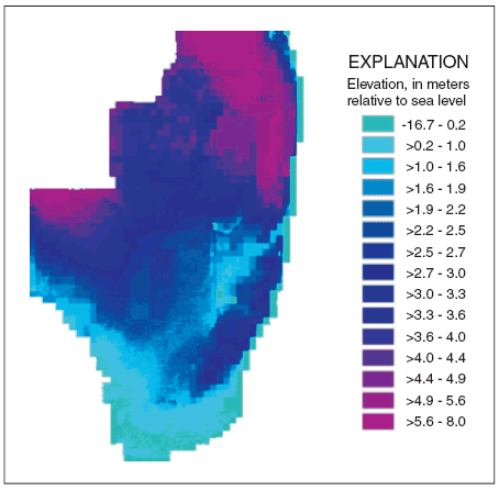 |
| Figure 1. ATLSS High Resolution Multi-Source Topography (HMDT). |
ATLSS has produced a set of Spatially Explicit Species Index (SESI) models that are designed to assess the relative potential for breeding and/or foraging success of modeled species across the greater Everglades landscape under various proposed hydrologic scenarios. The species modeled are:
SESI models incorporate information, such as vegetation type, and relating suitable conditions for these species to local habitat conditions and yearly hydrologic conditions, producing yearly performance values between 0 and 1 for each 500 x 500-m cell in the model area.
Until recently, information on populations had been too sparse to calibrate and test these models. Empirical data are now becoming available, and the SFWMM output data extends beyond its previous period of 1965-95 to 1965-2000, which allows comparisons between models and data over a longer time period than was previously possible. Even with these increases in available data on population sizes, it is not possible to calibrate and test SESI models directly against such data, as the SESI models only provide relative indices of habitat suitability, not population estimates.
The reliability of SESI models can nonetheless be evaluated by comparing year-to-year trends in SESI outputs with year-to-year trends in empirical data. As an example of how such comparisons can be made, consider the yearly empirical estimates from survey counts (that is, observed singing males multiplied by 16 to estimate total population) of the Cape Sable sparrow population for a given subregion, the "western subpopulation," of its range. Data are available for 1981 and the period 1992-2004. Because the SESI model produces values between 0 and 1, the SESI values must first be normalized to the population data in order to compare SESI model trends with population data. To do this, the SESI index is averaged over the entire western subregion and then rescaled to be comparable to population data. This was done for figure 2 where the normalized SESI index is calibrated to the 1981 count of sparrows. If the SESI model is a good representation of the sparrow breeding conditions, then the normalized SESI index (black dots) would be expected to track subsequent survey counts (red crosses). The SESI index does seem to track population values over most of the period from 1992 to 2002, although observed values are lower than model projections during 2001 and 2002. This deviation may reflect environmental changes in the western subpopulation's habitat that are not yet incorporated in the model, such as changes in vegetation.
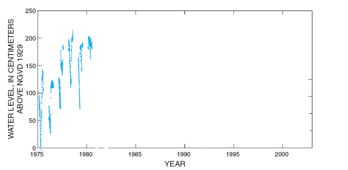 |
| Figure 2. Water level during sparrow breeding season at NP205 gage (blue). Observed population (red) and simulated population (black) are expressed as proportion of maximum potential population that is realized. Population deficit curves follow the general pattern of intensity of dry-downs, except for 1994, a year when water depths measured at sparrow sampling stations deviated from the NP205 gage trends. |
The Systematic Reconnaissance Flight (SRF) dataset is an important source of empirical population data for testing some of the SESI models. A protocol has been developed by the ATLSS Program for using SRF data on wading bird nesting and foraging distributions to test the SESI models for the wading birds. Because subperiods within the wading bird breeding season may be important determinants of wading bird foraging sites, SESI output will be generated for monthly periods within each breeding season. Graphical output of monthly SESI component metrics will be compared to monthly SRF abundance counts. The graphical time-series comparison of yearly SESI potential and observed abundance (by subregion of interest) also will be made. Finally, three-panel comparisons between empirical data and SESI values will be made after aggregating to compatible scales.
In addition to SESI models, the ATLSS program has developed population demographic models for a number of species. One example is the individual-based model EVERKITE, which has been developed to project population change of the Florida snail kite (Rostrhamus sociabilis) under future hydrologic scenarios. The Florida snail kite is an endangered raptor that occurs as a closed population of about 2,000 birds in the wetlands of southern and central Florida.
Its demography is severely affected by the hydrology of these wetlands. As basic information for any predictive model, good empirical studies are required. A large number of empirical studies have been done on the Florida snail kite. These studies provide the correlative relations between specific aspects of the snail kite life history and behavior with the hydrology of the system. These relations form the building blocks of any hydrology-driven population dynamical model.
With this tool in hand, we approached the challenge of making reliable projections of future population development of the snail kite under various hydrologic scenarios. The reliability of the model could be judged by comparing its predictions for the historical hydrologic patterns with observed demographic patterns during the past decades. The most logical dataset to be used for this comparison is the annual count of snail kites that was performed during 1969-95. This dataset has been criticized, however, for being biased in several ways. Without an unbiased dataset on kite demography, it is hardly possible to check the reliability of the kite model for the historical situation, which affects the faith one should have in the model in discriminating among hydrological scenarios.
Rather than implementing a single version of the model, we implemented a suite of model versions, representing the structural uncertainty in our understanding of the dynamics of the kite population. For each model version we developed a number of parameterizations, representing the uncertainty in the model parameters. We will evaluate each hydrological scenario for each model version for each parameterization, focusing on the long-term population growth rate (lambda) as the main response parameter. This analysis will enable us to evaluate whether structural uncertainty and parameter uncertainty interact with differences due to hydrological scenarios. If these interactions are absent, they will prove to be a reliable tool for scenario evaluation, despite considerable structural and parameter uncertainty.
Because changes in hydrology over a period of years are likely to result in significant changes in vegetation across the landscape, an ATLSS vegetation succession model (VSMod) has been developed. The model is designed to estimate changes in the distribution of vegetation in the Everglades resulting from changes in hydrology, fire disturbance, and nutrient levels. The model covers most of the natural areas of southern Florida, including the three water-conservation areas, Everglades National Park (ENP) and Big Cypress National Preserve (BCNP). Additionally, a few smaller surrounding natural areas also are included. The model excludes urban and agricultural areas, as well as portions of mangrove forest along the southern and western coasts of the Florida.
Like most of the other ATLSS models, the spatial resolution of VSMod is 500 x 500 m. The temporal resolution of the model is 1 year, and the beginning of each model year is synchronized with the end of the natural fire/dry season of the Everglades (April/May). VSMod uses a number of inputs with the primary ones being annual hydroperiod estimates, annual area burned by hot and cool fires, vegetation distribution, and parameters that describe the environmental tolerances of each input vegetation type. The vegetation distribution input provides two pieces of information for the succession model: the vegetation classes used and an initial condition. Currently, the ATLSS VSMod uses FGAP v6.6 as the vegetation input. This input uses a 30 x 30-m grid. It contains 78 habitat types, of which about 58 represent natural vegetation communities. From these 58 types, the VSMod uses only 25. Most of the 33 types not used by the VSMod are outside the ATLSS study area. A few have very low representation within the ATLSS study area, and these types are lost when the FGAP data are rescaled to the 500 x 500-m resolution. For this reason we omitted them from the model.
For each of the vegetation types in the vegetation map, the model contains parameters that represent the environmental tolerances of the community represented by each type. Parameters include:
To show changes in vegetation type from year to year, model output can be represented in two-panel diagrams in which the map of vegetation for a particular year is beside a map showing the cells that have changed from the preceding year (fig. 3).
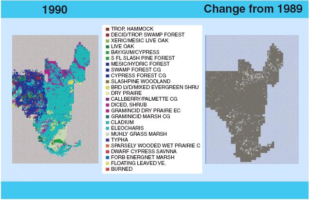 |
| Figure 3. Output of ATLSS vegetation succession model, VSMod. The left-hand panel shows the vegetation cover predicted for 1990. The right-hand panel indicates cells that have undergone change from the cover of the preceding year. |
ATLSS models are designed to be used by a wide range of stakeholders. Most stakeholders do not have the means or desire to maintain and run ATLSS models on their own computer systems, but would like to choose hydrologic input sets for the ATLSS models and obtain output with a minimum amount of effort. To make ATLSS model results directly accessible for natural resource managers, a new ecosystem modeling service suite has been developed. This utilizes grid-computing technologies, network-based middleware access control, and visualization resources to remove the impediments for application by stakeholder agencies. This service suite also provides new tools that enhance the ability of stakeholders to carry out assessments based in part upon the criteria they choose. The goal of the suite is to assist stakeholder groups in applying both current and future models by: (1) incorporating new data in the models, (2) comparing models to data, (3) contrasting results from different scenarios, and (4) incorporating and contrasting results for two different trophic levels (such as wading bird and fish). Specifically, the ecosystem modeling service suite allows natural resource managers in southern Florida to remotely launch ecosystem modeling tasks on, and harvest model results from, a high-performance computing grid at the University of Tennessee with the use of minimal local resources.
The user accesses the university computing grid through an HTML user interface using a web browser (fig. 4). Two software programs NetSolve and Internet Backplane Protocol (IBP) then allow models to be run remotely. NetSolve manages several servers at the university and allows external users to run models on various platforms without the need for individual system logins or accounts on those computers. IBP allows rapid access to data used in the ATLSS models. Users can specify which of several hydrologic files they choose to use as input to the models. The HTML interface allows the users flexibility in varying some of the ATLSS model parameters. Once ATLSS model output is generated, it can be stored locally by the users, who can then use the ATLSS Data Viewer to examine the output data and compare scenarios.
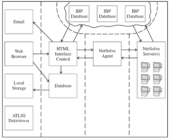 |
| Figure 4. Flow chart of the system for producing ATLSS runs remotely. |
For further information contact:
Donald L. DeAngelis
U.S. Geological Survey
Florida Integrated Science Center Water and Restoration Studies
Department of Biology
University of Miami
Coral Gables, FL 33124
Phone: 305-284-1690
Fax: 305-284-3039
E-mail: don_deangelis@usgs.gov
This report is available online in Portable Document Format (PDF). If you do not have the Adobe Acrobat PDF Reader, it is available for free download from Adobe Systems Incorporated.
Download the report (PDF, 3.2 MB)
Document Accessibility: Adobe Systems Incorporated has information about PDFs and the visually impaired. This information provides tools to help make PDF files accessible. These tools convert Adobe PDF documents into HTML or ASCII text, which then can be read by a number of common screen-reading programs that synthesize text as audible speech. In addition, an accessible version of Acrobat Reader 5.0 for Windows (English only), which contains support for screen readers, is available. These tools and the accessible reader may be obtained free from Adobe at Adobe Access.
| AccessibilityFOIAPrivacyPolicies and Notices | |
 |
|