
A significant population of Florida’s manatees (Trichechus manatus latirostris) occurs in southwest Florida, including extensive protected areas within the Ten Thousand Islands (TTI) and Everglades National Park (ENP). In this wilderness area, manatees are frequently seen using offshore seagrass beds, estuarine bays, tidal creeks, and rivers. Upstream from these relatively undisturbed ecosystems, humans have greatly modified the natural hydrologic patterns through extensive systems of canals, ditches, weirs, roads, and culverts. Historically, water moved across this landscape gradually as sheetflow, but human structures now rapidly drain the landscape, resulting in large pulses of freshwater discharged into the estuaries during the wet season, followed by little or no discharge during the dry season. Several restoration projects are planned or are underway within ENP and TTI to restore freshwater flow to historic levels, and these alterations may have effects on manatees using freshwater, estuarine, and near-offshore areas downstream from these projects.
A major goal of this study is to obtain baseline data on manatee distribution, relative abundance, habitat use, and movement patterns within the study area (fig. 1) prior to restoration. By collecting data before and after the restoration, we can evaluate how manatees respond to altered water management regimes, perhaps mediated by changes in availability of freshwater for drinking and seagrasses for foraging. These data also are being used to parameterize an individual-based population model that simulates the movement patterns of manatees under different hydrologic conditions.
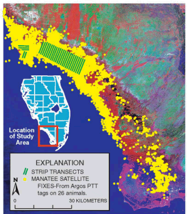 |
| Figure 1. Study area showing strip transects (black lines) and manatee satellite fixes (17,753 yellow dots) from Argos PTT tags (26 animals) from June 2000 to December 2003. |
Two primary field methods are being used to monitor manatees in the study: aerial surveys and satellite telemetry. Monthly manatee distribution surveys are flown year round following the same inland and offshore flight path (fig. 2). Strip-transect aerial surveys involve summer flights along parallel flight paths that are roughly perpendicular to the coast line (fig. 2). The strip transect approach has been successfully used to estimate manatee densities in the Banana River, Florida (Miller and others, 1998). Satellite telemetry has been used extensively along the east coast of Florida to document seasonal movement patterns, migratory behavior, and site fidelity (Deutsch and others, 2003). In combination, aerial surveys and satellite telemetry provide complementary data on coarse-scale population trends versus detailed movement patterns.
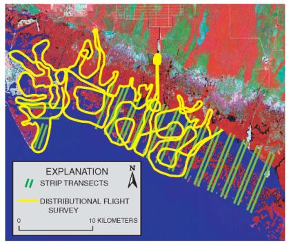 |
| Figure 2. Strip transects (green lines) and distributional flight survey (yellow lines). |
Thirty distribution surveys were flown from August 1999 to February 2002. Six strip transect surveys were flown in summer 2000, eight in 2001, and eight in 2002. The parallel transects are 3.4 to 8.4 km in length, 1 km apart, with a survey strip width of approximately 250 m. Two observers in the cockpit independently record each sighting according to location, manatee activity, and group size. The independent data are used in abundance analysis to directly estimate and correct for manatees that may be missed by the observer.
We used two types of satellite systems to acquire geographic locations from tagged manatees (fig. 3). Most tagged manatees were fitted with Argos transmitters, providing approximately four location fixes per 24-hour period. We also used GPS tags that provided much more accurate locations than the Argos data (approx. 30 m versus 150 m) every 15-30 minutes, but the battery life was much shorter (8 weeks versus 6 months). In combination, the Argos data provided region-wide, long-term coverage suitable for revealing general patterns of habitat use, while the GPS data showed fine details of travel pathways and time spent in specific areas. Most manatees were captured and radio-tagged during the winter months at Port of the Islands, Faka Union canal, Collier County.
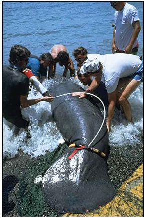 |
| Figure. 3. Captured manatee being released with radio transmitter. |
The aerial survey data show that the Ten Thousand Islands region is an important area for manatees. In the wet season manatees were dispersed across the area in small groups. The majority of sightings were of manatees in offshore bays feeding on seagrass. Fewer, but consistent numbers were sighted inland in canals, rivers, and creeks with a higher percentage inland in dry season than in wet. These patterns were comparable over the years of data.
The patterns identified from the aerial survey data were substantiated by the telemetry data, with even greater detail and insight into the activity patterns of the manatees. Satellite-based Argos transmitters were used to remotely track movements of 26 manatees between June 2000 and December 2003, yielding 17,753 high quality fixes for 6,793 tag-days (fig. 1). A large number of fixes occurred in inland sites, often many kilometers upstream in canals, rivers, and creeks. During the dry season (March – May) manatees spend nearly 25 percent of their time upstream in inland sites, whereas during the wet season (July – September) they spend much more time offshore foraging on seagrass beds.
GPS tags, placed opportunistically on 15 manatees through August 2004, show a pattern similar to the Argos data. The GPS data show detailed pathways as manatees move between offshore and inland areas (fig. 4). GIS analyses of these movement patterns show that manatees make frequent, regular movements between offshore and inland zones (fig. 5, bottom graph). Tagged manatees typically spent less than a day at inland sites, but often remained on offshore seagrass beds for several days. All tagged manatees showed a similar pattern of alternating between the two zones at regular intervals ranging from 2-8 days throughout the year. While transitioning from one zone to another, their rate of travel increased substantially, often spiking upwards to 2 or 3 kilometers per hour (fig. 5, top graph). Upon arriving at an inland or offshore zone, travel rates decreased greatly. These directed movements were not only frequent, and rapid, but often involved traveling many tens of kilometers, requiring a significant expenditure of energy. Such costly movements suggest the importance to manatees of both offshore seagrass and inland sites.
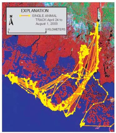 |
| Figure 4. GPS track for a single animal (Anna) April 24 to August 1, 2003 showing typical inshore-offshore movements. |
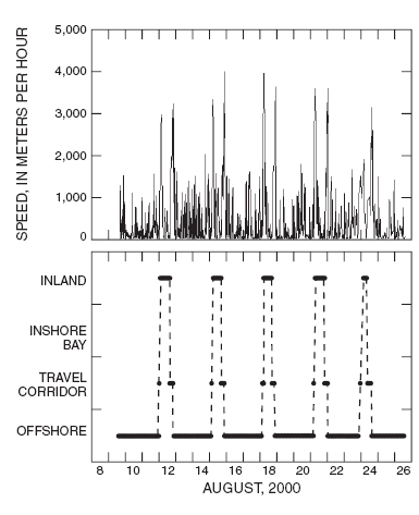 |
| Figure 5. GIS Analysis of GPS data for one individual (Surfer) during August 2000, showing speed of movement (top) and regular movement between offshore feeding areas (seagrass) and inland freshwater sites (bottom). |
For 6 individuals that were tracked for at least one full wet and dry season, we compared their use of freshwater access points. During the dry season, most manatees (13 of 15 animal-seasons) visited the Faka Union Canal freshwater site, which is the most reliable source of freshwater in the study area. During the wet season, most manatees (8 of 12 animal-seasons) shifted their home range and never visited the Faka Union site. Water monitoring stations in the study area show that during the wet season freshwater is readily available at many localities; during the dry season these same stations show saline or hypersaline conditions.
Evidence for the importance of freshwater to manatees has been provided recently by physiological studies (Ortiz and others, 1999). This study provides some of the first evidence from manatee movement patterns showing the importance of freshwater sites to manatees. Because restoration activities are expected to change the timing and quantity of freshwater inflow to rivers and canals in the study area, we expect manatee movement patterns to change in response to the changing availability of freshwater. The abundance and distribution of manatees likely will track the increased availability of freshwater associated with restoration.
To further address this issue, we are developing an individual-based population model that simulates manatee behavioral responses to changes in hydrologic restoration. We are also exploring the application of a new statistical approach to better estimate abundance and changes in distribution by directly estimating and accounting for manatees unseen below the surface during an aerial survey. As restoration begins, first on the smaller scale Southern Golden Gate Estates project centered around the Faka Union Canal, then on the larger Comprehensive Everglades Restoration Project (CERP), we expect to continue using aerial surveys and telemetry to monitor the response of manatees to restoration.
This study supports the following tasks for the U.S. Department of the Interior (Science Plan in Support of Ecosystem Restoration, Preservation, and Protection in South Florida, May 2004): Southern Golden Gate Estates Hydrologic Restoration project, by modeling predicted changes in hydrology and ecology in the Ten Thousand Islands NWR, and providing baseline data and monitoring of effects on a federally listed species, the West Indian manatee, within the Ten Thousand Islands NWR. The study also supports the Landscape-Scale Modeling effort by providing an individual-based demographic model of a threatened species, the West Indian manatee, and by providing landscape-scale monitoring and assessment for the CERP Monitoring and Assessment Plan.
Deutsch, C.J., Reid, J.P., Bonde, R.K., Easton, D.E., Kochman, H.I., and O’Shea, T.J., 2003, Seasonal movements, migratory behavior, and site fidelity of West Indian manatees along the Atlantic Coast of the United States: The Wildlife Society, Wildlife Monographs No. 151, 77 p.
Miller, K.E., Ackerman, B.B., Lefebvre, L.W., and Clifton, K.B., 1998, An evaluation of strip-transect aerial survey methods for monitoring manatee populations in Florida: Wildlife Society Bulletin 26(3):561-570.
Ortiz, R.M., Worthy, G.A.J., and Byers, F.M., 1999, Estimation of water turnover rates of captive West Indian Manatees (Trichechus manatus) held in fresh and salt water: Journal of Experimental Biology 202:33-38.
Additional information is available on the South Florida Information Access (SOFIA) website: http://sofia.usgs.gov/projects/manatees
For more information
Jim Reid or Brad Stith
U.S. Geological Survey
412 NE 16th Ave., Room 250
Gainesville, FL 32601
Phone: (352) 372-2571
Fax: (352) 374-8080
Terry Doyle
U.S. Fish and Wildlife Service
Ten Thousand Islands National Wildlife Refuge
3860 Tollgate Blvd., Room 360
Naples, FL 34114
(239) 353-8990
This report is available online in Portable Document Format (PDF). If you do not have the Adobe Acrobat PDF Reader, it is available for free download from Adobe Systems Incorporated.
Download the report (PDF,4.9 MB)
Document Accessibility: Adobe Systems Incorporated has information about PDFs and the visually impaired. This information provides tools to help make PDF files accessible. These tools convert Adobe PDF documents into HTML or ASCII text, which then can be read by a number of common screen-reading programs that synthesize text as audible speech. In addition, an accessible version of Acrobat Reader 5.0 for Windows (English only), which contains support for screen readers, is available. These tools and the accessible reader may be obtained free from Adobe at Adobe Access.
| AccessibilityFOIAPrivacyPolicies and Notices | |
 |
|