
|
Monitoring of earthquake shaking in buildings is a key to improving building design. Federal buildings are scattered throughout the Nation, and tens of thousands of them, worth an estimated $20 billion, are located in the most hazardous earthquake zones of the United States. By instrumenting a variety of these structures, scientists and engineers can acquire a rich data set on building response in earthquakes. Monitoring the behavior of Federal buildings during strong shaking will help to improve building design and reduce losses in future earthquakes. |
The United States Federal Government owns or leases more than 400,000 buildings, distributed through all regions of the Nation. The Government Accounting Office (GAO)1 reported in 1992 that 40 percent of these buildings are in areas of significant earthquake hazard, and 20 percent are in zones where the hazard is high to very high. The estimated replacement value of the Federal buildings in the most hazardous earthquake zones is $20 billion.
 |
|
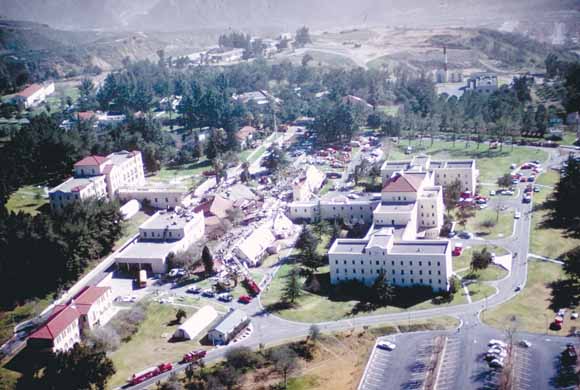
The 1971 San Fernando earthquake (magnitude 6.7) collapsed four buildings at the San Fernando Veterans Administration Hospital complex (above), killing 47 people. The buildings had been built in 1925, before building codes were in effect. |
 |
|
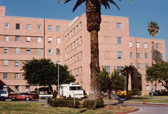
In the 1994 Northridge earthquake (also magnitude 6.7), a building in the Sepulveda Veterans Administration Hospital complex, though built to code, was still damaged by strong shaking. Seismic joints separated, and building sections pounded against one another. |
 |
|
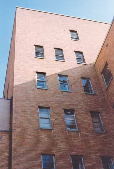
Piers between windows cracked. Instrumenting such buildings will advance understanding of their response to earthquake shaking. |
Although improvements in design and construction practices in the United States have markedly reduced deaths from building collapse during earthquakes, strong shaking in urban areas still causes serious damage to buildings, resulting in severe economic losses. The lower death toll in the 1994 Northridge, California, earthquake (magnitude 6.7) than in the nearby and same-size San Fernando shock of 1971-despite the region's high population growth in the intervening decades-was largely the result of improved building design. Nonetheless, the Northridge quake still caused about $20 billion damage to buildings in the San Fernando Valley and the Los Angeles Basin.
|
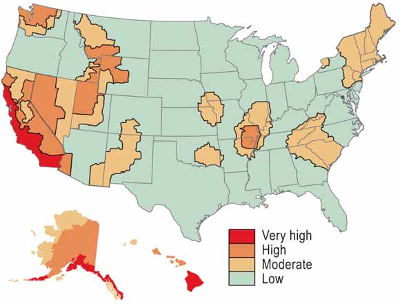
Seismic Risk-Zone Map of 1992
|
 |
|
The seismic risk-zone map from the 1992 Report of the Government Accounting Office (GAO) shows the geographic spread of the earthquake hazards confronting the Nation. The GAO report found that 40 percent of Federal buildings are in areas of significant earthquake hazard, and 20 percent are in zones where the hazard is high to very high. |
To improve the seismic performance of buildings, engineers need a better understanding of how existing structures respond during severe shaking. This goal requires instrumenting a large number of buildings and recording their response during strong earthquakes. The resulting data set should span the range of variability in building, site, and earthquake characteristics:
Recordings of strong shaking in buildings allow engineers to:
 |
 |
|
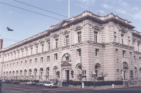
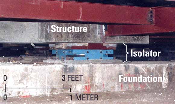
The 100-year-old Court of Appeals Building in San Francisco, California was retrofitted after the 1989 Loma Prieta earthquake using base-isolation technology (lower illustration) and was fully reoccupied in 1996. Base-isolation systems dampen the shaking energy fed into the structure through its foundation, thus reducing the likelihood of damage. Sensors placed below and above the isolators allow measurement of the effectiveness of the system. |
In an effort to provide these much-needed recordings, scientists and engineers of the U.S. Geological Survey (USGS) and cooperating institutions are working to instrument a wide range of buildings in areas of significant seismic hazard.
Federal buildings are especially attractive targets for seismic monitoring. They are of varied sizes and configurations and are spread across all areas of seismic hazard in the Nation. In addition, in most cases they do not present some issues that impede the instrumentation of private structures, such as obtaining the required permission of a private owner. Private owners may not want buildings to be monitored for shaking out of fear of possible litigation following a damaging earthquake.
There are many advantages to placing arrays of shaking sensors in Federal buildings:
 |
|
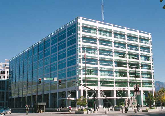
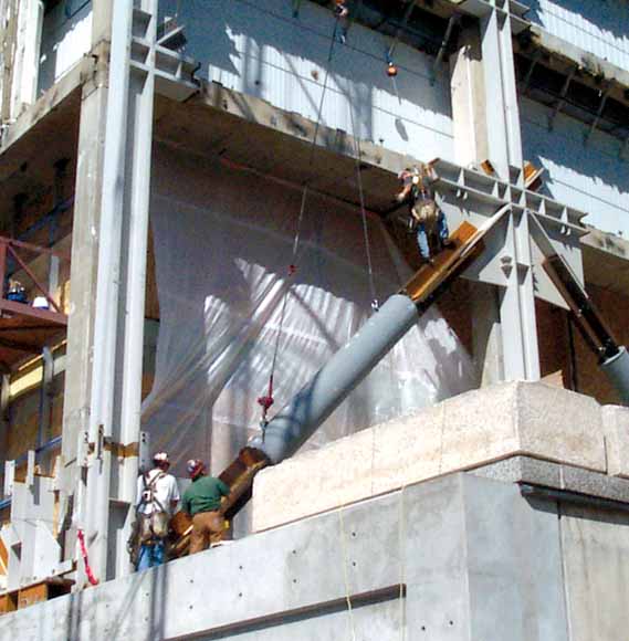
The Bennett Federal Office Building in Salt Lake City, Utah, built in 1965, underwent a major seismic retrofit completed in 2003. |
 |
|
To reduce the shaking in the structure during strong earthquakes, the building was fitted with novel, unbonded diagonal braces and dampers. |
 |
|
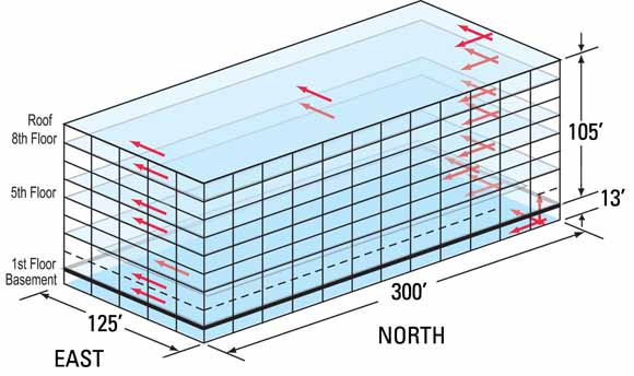
Sensors have been deployed throughout the building to validate the expected improvement in seismic performance of the building during strong tremors. Red arrows indicate the locations of the sensors and show the 26 components, or directions, of motion that the sensors record. |
Federal buildings need to be instrumented to record their response to strong ground shaking. However, not all Federal buildings can, or need, be monitored for shaking. Rather, an appropriate strategy is to selectively monitor buildings representative of the most common building types in the Federal inventory. Information obtained from shaking sensors installed in one building can be applied to benefit similar structures underlain by equivalent geologic conditions. Important historical buildings, occupied by Federal agencies, that have been previously strengthened to resist earthquakes are also suitable monitoring targets in order to validate or improve those retrofit strategies.
Among the Federal buildings already instrumented with shaking sensors or in the process of being instrumented are 59 Veterans Administration hospitals, 12 General Services Administration office buildings, and 8 National Atmospheric and Space Administration laboratory structures.
Installation of shaking monitors in buildings is part of the program of research conducted under the National Earthquake Hazards Reduction Program (NEHRP). The results of NEHRP studies improve understanding of the earthquake loads that buildings are likely to experience and help engineers design structures more resistant to earthquakes.
The USGS—the Nation's leading earth-science agency-works closely with Federal and State agencies, regional and city governments, and private building owners to monitor earthquake shaking in buildings, as well as in bridges and dams. The pace of progress in safeguarding the Nation's building inventory against future earthquake losses can be accelerated significantly through expanded seismic monitoring of Federal buildings.
By Mehmet Çelebi and Robert Page
Edited by Peter H. Stauffer
Graphic design by Susan Mayfield and Judy Weathers; Web layout by Michael Diggles
COOPERATING ORGANIZATIONS
Federal Deposit Insurance Corporation
Federal Highway Administration
General Services Administration
Interagency Committee on Seismic Safety in Construction
National Atmospheric and Space Administration
U.S. Army Corps of Engineers
U.S. Bureau of Reclamation
U.S. Department of Veterans Affairs
For further information contact:
Earthquake Information Hotline (650-329-4085)
U.S. Geological Survey, Mail Stop 977
345 Middlefield Road, Menlo Park, CA 94025
URL http://quake.usgs.gov/research/
PDF version of this fact sheet (576 KB)
Download a copy of Adobe Reader for free
| Help
| PDF help
| Geopubs main page | Fact Sheets |
| U.S. Geological Survey
| Geologic Division | Earthquake
Hazards Program |
| Department of the Interior
| Privacy Statement | Disclaimer
| Accessibility |
URL of this page: https://pubs.usgs.gov/fs/2005/3052/
Maintained by: Michael Diggles
Created: December 19, 2005
Last modified: December 19, 2005 (mfd)