 |
|
|
||||
| Office of Ground Water |
U.S. Geological Survey Fact Sheet 2005-3095
By Paul M. Barlow
This report is available as a pdf.
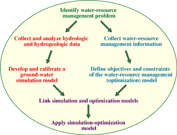
Increasing—and often competing—demands on the Nation's ground-water resources are creating a need for improved scientific information and analysis techniques to better understand and manage ground-water systems. Since the 1960s, numerical simulation models have been important tools for the assessment of ground-water flow systems and ground-water development strategies. Commonly, these models are used to test specific water-resource management plans, or, in a trial-and-error approach, to select a single plan from a few alternative plans that best meets management goals and constraints. Because of the complex nature of ground-water systems, however, and the large number of engineering, legal, and economic factors that often affect ground-water development and management, the process of selecting a best operating procedure or policy can be extremely difficult. To address this difficulty, ground-water simulation models have been linked with optimization-modeling techniques to determine best (or optimal) management strategies from among many possible strategies. Optimization models explicitly account for water-resource management objectives and constraints, and have been referred to as management models (Ahlfeld and Mulligan, 2000). The use of combined simulation-optimization models greatly enhances the utility of simulation models alone by directly incorporating management goals and constraints into the modeling process (fig. 1). In the simulation-optimization approach, the modeler specifies the desired attributes of the hydrologic and water-resource management systems (such as minimum streamflow requirements or maximum allowed ground-water-level declines) and the model determines, from a set of several possible strategies, a single management strategy that best meets the desired attributes. In some cases, however, the model may determine that none of the possible strategies are able to meet the specific set of management goals and constraints. Such outcomes, while often not desirable, can be useful for identifying the hydrologic, hydrogeologic, and management variables that limit water-resource development and management options.
Because of their usefulness for evaluating complex hydrogeologic and water-resource management systems, simulation-optimization models have been developed to assess various types of regional ground-water management problems, such as
Combined simulation-optimization models also can be used to determine tradeoffs between various hydrologic constraints and future uses of the Nation's ground-water resources. The U.S. Geological Survey (USGS) has been an important contributor to the development and application of both simulation and simulation-optimization models for assessment of ground-water flow systems. These models advance our understanding of hydrologic systems and hydrologic processes, and provide a scientific basis for determining how water-resource development affects hydrologic systems. Recently, simulation-optimization models have been applied to the important issue of ground-water sustainability—a broad topic that includes the interaction between hydrologic systems, water-resource management decisions, environmental impacts, and emerging technologies (National Research Council, 2000). Two case studies from Rhode Island and Arkansas are described in the following sections to demonstrate the use of simulation-optimization modeling in USGS investigations. Additional applications to ground-water management issues in Wisconsin and California are given in Walker and others (1998) and Reichard and others (2003), respectively. The final section of this Fact Sheet describes a new computer program to facilitate simulation-optimization modeling. EFFECTS OF MINIMUM STREAMFLOW CRITERIA ON GROUND-WATER PUMPING, BIG RIVER BASIN, RHODE ISLANDShallow, high-yielding sand and gravel aquifers are an important source of water for many communities of the northeastern United States. Typically, ground-water wells that pump water from these aquifers are located close to streams and rivers that are in direct hydraulic connection with the underlying ground-water system. Pumping from these wells reduces streamflow by capturing ground water that would otherwise discharge to the streams and, in some cases, by drawing water out of the streams and into the adjoining aquifer.
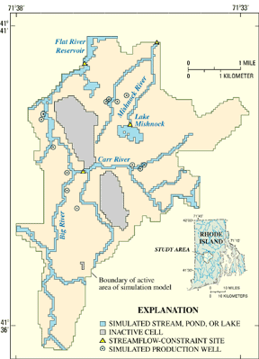
Streamflow reductions caused by ground-water pumping can be an environmental problem when such reductions decrease the amount of water that is available to aquatic and riparian communities below minimum levels required to sustain healthy ecosystems. In response to such reductions, many States and communities are attempting to define minimum streamflow criteria that are protective of aquatic and riparian habitats. For example, the State of Rhode Island recently developed minimum streamflow standards that protect the biological, chemical, and physical integrity of the State's waters, but also allow for maximum sustainable use of these waters. One area of the State to which these standards may be applied is the Big River Basin (fig. 2), which is a largely untapped and potential future source of water for the State. The USGS, in collaboration with the Rhode Island Water Resources Board, recently developed a simulation-optimization model for the basin to determine the relation between minimum streamflow criteria and ground-water withdrawals (Granato and Barlow, 2005).
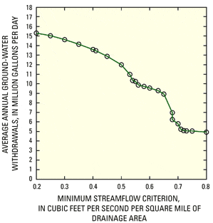
The simulation-optimization model was developed to determine the maximum amount of ground water that could be pumped from 13 wells distributed across the basin while simultaneously maintaining minimum streamflow rates at four locations in the basin (referred to as streamflow-constraint sites in figure 2). The values of the minimum streamflow rates were varied in a series of model runs to test several criteria that are being considered by the State. Ground-water pumping rates were calculated for several model runs (fig. 3). Each streamflow criterion is
plotted on figure 3 as the minimum amount of streamflow required at each of the four streamflow-constraint sites per square mile
of drainage area to each site. For the criteria shown in figure 3, model-calculated average annual pumping rates from the basin ranged from
a minimum of about 5 Mgal/d (million gallons per day) for the most restrictive criteria to a maximum of about 15 Mgal/d for the least
restrictive. The graph indicates that relatively small changes in the streamflow criteria can result in large changes in model-calculated
pumping rates. For example, a decrease in total pumping of almost 4 Mgal/d was calculated for an increase in the streamflow
requirement from 0.65 cubic feet per second of streamflow per square mile of drainage
area (ft3/s/mi2) to 0.72 (ft3/s/mi2).
The nonlinear shape of the graph results from the unique hydrologic and hydrogeologic characteristics of the Big River
Basin and the specific set of well sites and streamflow locations used in the simulation-optimization model. The results
shown on the figure would have been difficult to determine by use of a simulation model alone. ESTIMATION OF SUSTAINABLE YIELD FROM THE MISSISSIPPI RIVER VALLEY ALLUVIAL AQUIFER, SOUTHEASTERN ARKANSAS
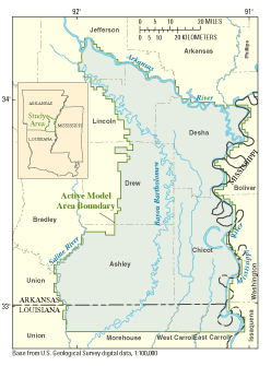
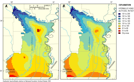
The Mississippi River Valley alluvial aquifer underlies an area of about 32,000 square miles in eastern Arkansas and several adjacent States. Historically, the aquifer has provided large volumes of water for agriculture in Arkansas. Because of heavy demands placed on the aquifer, water levels have declined in several areas. In some places, these declines have resulted in decreasing water availability, lower well yields, and degraded water quality. In response to these water-level declines, several counties in southeastern Arkansas that lie within the extent of the alluvial aquifer have been designated Critical Ground-Water Areas by the Arkansas Soil and Water Conservation Commission (ASWCC) (Czarnecki and others, 2003). This designation is made in areas where ground-water-level declines have reduced the original (predevelopment) saturated thickness of the aquifer by more than 50 percent. The effects of ground-water withdrawals on continued water availability from the alluvial aquifer are major concerns of water managers, water users, and the general public. These concerns have resulted in a continued cooperative effort by the ASWCC, the U.S. Army Corps of Engineers, and the USGS to develop, maintain, and utilize models to analyze the ground-water system and to provide information to assist water managers and policy makers to manage the ground-water resources. An important component of this cooperative effort has been the estimation of the sustainable yield of the aquifer, which is defined as the rate at which water can be withdrawn from the aquifer indefinitely without lowering water levels to less than half the predevelopment saturated thickness of the aquifer or reducing streamflow in hydraulically connected streams below minimum specified flow rates. A simulation-optimization model was developed as the basis for estimating the sustained yield of the aquifer. The model covers a 3,800-square-mile area lying south of the Arkansas River (fig. 4). The objective of the management model was to maximize water withdrawals from wells pumping from the alluvial aquifer and from two streamflow-withdrawal sites, one on the Arkansas River and the second on Bayou Bartholomew. Model-calculated withdrawals were limited, however, by several management constraints. First, for consistency with the ASWCC designation, water levels in the aquifer were required to remain higher than half the predevelopment saturated thickness of the aquifer. Second, simulated streamflows along the Arkansas River and Bayou Bartholomew were required to remain above minimum levels regulated by the ASWCC for purposes of maintaining water quality, navigation, and species habitat. Finally, maximum allowed withdrawal rates were specified at 1,841 model cells where wells were simulated. Total withdrawals from the aquifer within the modeled area were 73.5 million cubic feet per day (Mft3/d) in 1997, which was the baseline simulation period selected for the study.
The combined simulation-optimization model determined withdrawal rates at each of the 1,841 simulated well locations for three scenarios. In each of these scenarios, the maximum withdrawal rate allowed at each withdrawal location was equal to 100, 150, and 200 percent of the total 1997 withdrawal rate, respectively. Model results indicated that the sustainable yield of the aquifer is dependent on the maximum withdrawal rate allowed at the well sites; the yield increased from 70.3 (Mft3/d) for maximum withdrawal rates equal to 100 percent of the 1997 withdrawal rates to 110.2 (Mft3/d) for maximum withdrawal rates equal to 200 percent of the 1997 withdrawal rates. The model also indicated that the unmet demand of 3.2 (Mft3/d) for the first scenario, which is equal to the 1997 total withdrawal rate (73.5 (Mft3/d)) minus the optimal withdrawal rate calculated by the model (70.3 (Mft3/d)), could be satisfied by stream withdrawals, but these would require the construction of withdrawal and distribution facilities. Simulated water levels calculated for the 1997 withdrawal rates differed in several respects from those calculated on the basis of withdrawal rates determined for the first management scenario. For example, the 1997 withdrawal rates caused some areas of the aquifer to dewater, as shown by the dry areas of the model in figure 5A. In contrast, simulated water levels resulting from withdrawal rates determined by the simulation-optimization model yielded no dewatered areas (fig. 5B). These results illustrate how the model can assist water managers in determining pumping rates that prevent dewatering of the aquifer. GWM—A NEW GROUND-WATER MANAGEMENT PROCESS FOR MODFLOWSeveral computer codes have been developed during the past two decades to facilitate ground-water simulation-optimization modeling (Lefkoff and Gorelick, 1987; Greenwald, 1998; Zheng and Wang, 2002; Ahlfeld and Riefler, 2003; Peralta, 2004). These codes differ in the numerical model used to represent the ground-water flow system and the types of ground-water management problems that can be solved. Recently, the USGS worked collaboratively with researchers at the University of Massachusetts and Woods Hole Oceanographic Institution to develop a new optimization-modeling process for the widely used MODFLOW ground-water simulation model developed by the USGS (Harbaugh and others, 2000). The new process, which is called the Ground-Water Management (GWM) process (Ahlfeld and others, 2005), can be applied to a broad range of ground-water management problems, such as limiting ground-water-level declines or streamflow depletions, managing ground-water withdrawals, and conjunctively using ground water and surface water. Management variables that can be specified in GWM include withdrawal and injection wells, artificial-recharge basins, and imports and exports of water. The types of constraints that can be specified include upper and lower bounds on pumping and injection rates, water-supply demands, hydraulic-head constraints such as drawdowns and hydraulic gradients, and streamflow and streamflow-depletion constraints. GWM uses a widely applied technique called the response-matrix approach to solve ground-water management problems. The GWM code and supporting documentation can be accessed on the internet at http://water.usgs.gov/nrp/gwsoftware/mf2k-gwm/MF2K-GWM.html. Additional ground-water software developed by the USGS is provided at http://water.usgs.gov/software/ground_water.html. REFERENCES CITEDAhlfeld, D.P., Barlow, P.M., and Mulligan, A.E., 2005, GWM—A ground-water management process for the U.S. Geological Survey modular ground-water model (MODFLOW-2000): U.S. Geological Survey Open-File Report 2005-1072, 124 p. Ahlfeld, D.P., and Mulligan, A.E., 2000, Optimal management of flow in groundwater systems: San Diego, CA, Academic Press, 185 p. Ahlfeld, D.P., and Riefler, Guy, 2003, Documentation for MODOFC—A program for solving optimal flow control problems based on MODFLOW simulation, version 2.3: Amherst, MA, University of Massachusetts Department of Civil and Environmental Engineering, 48 p. Czarnecki, J.B., Clark, B.R., and Stanton, G.P., 2003, Conjunctive-use optimization model of the Mississippi River Valley alluvial aquifer of southeastern Arkansas: U.S. Geological Survey Water-Resources Investigations Report 03-4233, 26 p. Granato, G.E., and Barlow, P.M., 2005, Effects of alternative instream-flow criteria and water-supply demands on ground-water development options in the Big River area, Rhode Island: U.S. Geological Survey Scientific Investigations Report 2004-5301, 110 p. Greenwald, R.M., 1998, Documentation and user's guide–MODMAN, an optimization module for MODFLOW, version 4.0: Freehold, NJ, HSI GeoTrans, 112 p. Harbaugh, A.W., Banta, E.R., Hill, M.C., and McDonald, M.G., 2000, MODFLOW-2000, the U.S. Geological Survey modular ground-water model — User guide to modularization concepts and the ground-water flow process: U.S. Geological Survey Open-File Report 00-92, 121 p. Lefkoff, L.J., and Gorelick, S.M., 1987, AQMAN-Linear and quadratic programming matrix generator using two-dimensional ground-water flow simulation for aquifer management modeling: U.S. Geological Survey Water-Resources Investigations Report 87-4061, 164 p. National Research Council, 2000, Investigating groundwater systems on regional and national scales: Washington, DC, National Academy Press, 143 p. Peralta, R.C., 2004, Simulation/Optimization Modeling System (SOMOS): Logan, UT, Utah State University Department of Biological and Irrigation Engineering, accessed July 28, 2004, at URL http://www.engineering.usu.edu/bie/ Reichard, E.G., Land, Michael, Crawford, S.M., Johnson, Tyler, Everett, R.R., Kulshan, T.V., Ponti, D.J., Halford, K.J., Johnson, T.A., Paybins, K.S., and Nishikawa, Tracy, 2003, Geohydrology, geochemistry, and ground-water simulation-optimization of the Central and West Coast Basins, Los Angeles County, California: U. S. Geological Survey Water-Resources Investigations Report 03-4065, 184 p. Walker, J.F., Saad, D.A., and Krohelski, J.T., 1998, Optimization of ground-water withdrawal in the Lower Fox River communities, Wisconsin: U.S. Geological Survey Water-Resources Investigations Report 97-4218, 24 p. Zheng, Chunmiao, and Wang, P.P., 2002, MGO—A Modular Groundwater Optimizer incorporating MODFLOW and MT3DMS, Documentation and user's guide: Tuscaloosa, AL, The University of Alabama and Groundwater Systems Research Ltd., 118 p.
AvailabilityThis report is presented in Portable Document Format (PDF). Suggested citation for this report, in USGS format: Barlow, P.M., 2005, Use of Simulation-Optimization Modeling to Assess Regional Ground-Water Systems: U.S. Geological Survey Fact Sheet 2005-3095, 4 p.
|

![]() U.S. Department of the Interior |
U.S. Geological Survey
U.S. Department of the Interior |
U.S. Geological Survey
URL: http://pubsdata.usgs.gov/pubs/fs/2005/3095/index.html
Page Contact Information: GS Pubs Web Contact
Page Last Modified: Tuesday, 29-Nov-2016 18:16:10 EST