By Kevin F. Dennehy
Fact Sheet 2005-3097 (530K PDF)
Although often overlooked, ground water is increasingly important to all of our lives. Ground water is the primary source of drinking water to approximately half the Nation's population (134 million people), provides about 40 percent of the irrigation water essential for the Nation's agriculture, sustains the flow of most streams and rivers, and helps maintain a variety of aquatic ecosystems. Moreover, the near-term trend in ground-water withdrawals for public supply and irrigation is continuing to rise (Hutson and others, 2004). As the Nation's principal reserve of freshwater, ground water requires periodic inventories and ongoing evaluations to ensure the resource is sufficient to meet the numerous needs of the Nation. This fact sheet provides a description of the U.S. Geological Survey (USGS) Ground-Water Resources Program and presents highlights of ongoing science activities.
Goals
What is the Ground-Water Resources Program?
The Ground-Water Resources Program is the principal USGS program for assessing the availability of ground-water resources at the regional and national scale (fig. 1). The Ground-Water Resources Program evolved from the Regional Aquifer-System Analysis (RASA) Program. RASA studies (1987–95) primarily were designed to quantify ground-water budgets for the Nation's principal aquifers, including depletions within those aquifers. The Ground-Water Resources Program updates and builds upon the RASA studies. Data collection and process-oriented ground-water science are used to assess the long-term availability of ground-water supplies while also addressing the environmental effects of ground-water development on land and surface-water resources. Studies currently funded by the Ground-Water Resources Program conduct regionally integrated ground-water assessments that fill the information gap between national efforts, such as the previous RASA studies, and local-scale efforts, conducted by the USGS Cooperative Water Program in conjunction with local partners. The scope and complexity of changing ground-water issues along with funding realities require integration of efforts both within the USGS and with other Federal, State, and local governments, as well as the private sector. Priorities for the Ground-Water Resources Program include regional and national overviews, scientific assessments of critical ground-water issues, field methods and model development, and improved access to fundamental ground-water data.
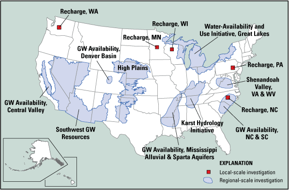
Figure 1. Locations of Ground-Water Resources Program studies in the United States, 2005.
Highlights of the Ground-Water Resources Program
Over the past decade, ground-water issues have evolved in scope and complexity as a result of escalating demands for the resource. USGS scientists are capable of addressing this increasing complexity by targeting a variety of information needs with a multi-component approach. The Program's mission and goals are achieved through the implementation of the following ground-water science components.
Regional Ground-Water Evaluations
The Ground-Water Resources Program addresses national and regional interests in ground water by supporting large-scale, multidisciplinary studies of ground-water availability. The studies commonly encompass multiple states and include scientific assessments of critical ground-water issues. Over time, the results of these individual ground-water availability studies can be combined to provide a national assessment. The following are examples of national and regional evaluations of the Nation's ground-water resources currently supported by the Ground-Water Resources Program.
Ground-Water Availability of Regional Aquifers
A major component of the Ground-Water Resources Program is regional ground-water availability studies that involve computer-based ground-water flow models as a tool for hydrologic assessments of the Nation's most important regional aquifers. Three regional aquifers geographically distributed across the United States were identified for study beginning in 2004: the Atlantic Coastal Plain aquifers in North and South Carolina, the Denver Basin aquifer in Colorado, and the Central Valley aquifer in California. In fiscal year 2006, a study of the Mississippi Alluvial and Sparta aquifers in parts of Arkansas, Louisiana, Mississippi, and Tennessee will begin (fig. 1). Information about these aquifers is critically needed to better manage the ground-water resources in these areas that are experiencing escalating demands. These assessments will document the effects of human activities (ground-water depletions) on ground-water levels, ground-water storage, and ground-water discharge to streams and other surface-water bodies. The selected studies emphasize a strong methods-development component that helps quantify and improve current understanding of the ground-water resources. Emphasis also is being placed on partnering, where possible, with other interested agencies to maximize the utility of the resultant products. Finally, the adequacy of data networks will be evaluated to assess the cumulative effects of ground-water withdrawals at a regional scale.
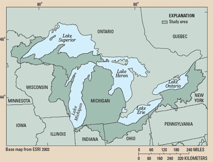
Water Availability and Use Initiative
|
The goals of the USGS Water Availability and Use Initiative, commencing in 2005 at the request of Congress, are to provide citizens, communities, and natural-resource managers with
The Initiative, which is in a pilot phase, focuses on the Great Lakes Basin (fig. 2). Additionally, a second pilot study focusing on ground-water depletion in the western United States will begin in fiscal year 2006. Other major water-resources regions will be added in the future as funding permits. Planned activities for the Great Lakes Basin pilot study include estimation of (1) spatial and temporal trends in streamflow characteristics, ground-water recharge, ground-water flow, and ground-water storage; (2) ground-water basin divides; and (3) water use. |
Natural Ground-Water Recharge
The need for mapping spatial and temporal variability of recharge to aquifers remains a topic of great interest. Improved knowledge of this variability will help water managers assess water availability and protect vulnerable aquifers under stress from increased demands on water resources because of expanding urbanization or drought. In response to that need, the Ground-Water Resources Program began an effort in 1999 to estimate regional ground-water recharge in the southwestern United States. In 2003, this effort was extended to more humid parts of the United States. Projects are being conducted in the States of Minnesota, North Carolina, Pennsylvania, Washington, and Wisconsin, and in cooperation with the National Water-Quality Assessment (NAWQA) Program, covering many other locations in the eastern United States. The objectives of these studies are to develop a better understanding of recharge processes at the local scale and to evaluate techniques to scale up site-specific recharge estimates to regional aquifers.
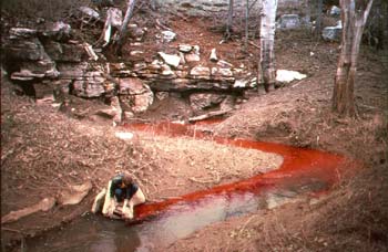
Rhodomine dye is injected in a stream to trace water movement through a karst aquifer (photograph by Charles Taylor, USGS).
Karst Hydrology Initiative/Fractured-Rock Aquifer Studies
Fractured rock and karst environments are collectively termed “complex aquifers” in the Ground-Water Resources Program. Karst and fractured-bedrock aquifers cover extensive areas of the United States and have unique physical characteristics that govern ground-water movement within these systems. Karst topography composes nearly 15 percent of the continental United States and about 40 percent of the land area located east of the Mississippi River (Davies and LeGrand, 1972). Much of the recent residential development along the Piedmont and in western mountain communities has occurred in areas underlain by fractured bedrock where the demand for new drinking-water sources cannot be satisfied by surface-water supplies (rivers or reservoirs). As growth continues, the problems of ground-water availability and vulnerability to contamination in these areas also will increase. In spite of the value of these complex aquifers as water-supply sources, the hydrogeologic characteristics of these systems are not as well understood as other aquifer systems, especially at a regional scale. Better regional characterization and understanding of the hydrogeology of complex aquifers as well as improved analytical and data-management tools are needed. The Ground-Water Resources Program is currently involved in a regional study of the karst aquifers in Alabama, Illinois, Indiana, Kentucky, and Tennessee as a prototype for possible regional studies of other karst aquifers. The Ground-Water Resources Program also is supporting complex aquifer studies in the Shenandoah Valley of Virginia and West Virginia.
Field Methods and Models
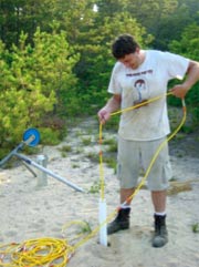 |
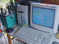 |
| Field testing and development of a web-enabled, earth-resistivity tomography monitoring system (photographs by Kamini Singha, USGS). |
The Ground-Water Resources Program supports many types and levels of hydrologic research, from basic research conducted by the USGS National Research Program to development of new field techniques, geophysical methods and applications, and computer models. The Ground-Water Resources Program strives to identify more efficient methods of evaluating ground-water resources at a variety of scales. Some examples of these activities are described below.
Geophysical Methods and Applications
The USGS supports the development and application of new geophysical techniques for water-supply and contamination studies. For example, the Ground-Water Resources Program supports work on a web-enabled, earth-resistivity tomography monitoring system to assess and monitor hydrologic processes, including aquifer storage and recovery and saltwater intrusion into coastal aquifers. Additional information on geophysical applications for ground-water studies is available on the Internet at http://water.usgs.gov/ogw/bgas/.
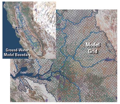
Figure 3. Application of MODFLOW-2000 to the Central Valley aquifer in California.
Ground-Water Model Development
The Ground-Water Resources Program continues to support the enhancement of MODFLOW with updates that help scientists and engineers simulate a variety of hydrologic processes that occur in ground-water systems (fig. 3). MODFLOW is one of the most popular ground-water flow models in the world, and the USGS continues to develop this widely used product as the science of ground-water hydrology advances and user needs change. Detailed information on MODFLOW enhancements is available on the Internet at http://water.usgs.gov/ogw/MODFLOW_list_of_reports.html. A high priority is being placed on the development of a coupled ground-water and watershed model. This work expands the capabilities of MODFLOW to better simulate ground-water and surface-water interactions at the basin scale by coupling MODFLOW with the Precipitation Runoff Modeling System (PRMS) watershed model. Additional information on these and other ground-water model codes is available on the Internet at http://water.usgs.gov/software/ground_water.html.
Data Collection and Ground-Water Level Monitoring Networks
Measurements of ground-water levels from wells are used to monitor changes in ground-water conditions resulting from climate variability and withdrawals. During drought conditions, when ground-water-level data are in high demand, real-time ground-water levels are measured at selected wells and transmitted to USGS databases for display on the Internet for water managers and the public. The Ground-Water Resources Program supports the Ground-Water Climate-Response Network of about 140 selected wells to assess the changes in ground-water conditions (storage and water levels) caused by climate stresses, especially drought. This network is augmented by ground-water-level monitoring that is supported by the USGS Cooperative Water Program. Water-level data can be viewed at http://groundwaterwatch.usgs.gov/.
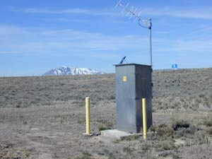
Real-time monitoring well that is part of the USGS Ground-Water Climate-Response Network in Idaho (photograph by Matthew Gilbert, USGS).
The Ground-Water Resources Program also supports regional evaluation of ground-water conditions where ground-water resources have been intensively developed, as in the High Plains aquifer in the central United States. For example, water with-drawal for irrigation from the High Plains aquifer for more than 50 years has resulted in substantial water-level declines in the aquifer. To understand the widespread effects of these long-term withdrawals on the aquifer, Congress has mandated that the USGS report water-level changes biennially. A network of more than 7,000 wells are measured annually by numerous Federal, State, and local agencies to assess water-level changes in the aquifer. More information on the High Plains Water-Level Monitoring Project is available on the Internet at http://ne.water.usgs.gov/html/hpactivities.htm.
Summary
Widespread debate concerning the Nation's ability to meet current and future demands for available freshwater resources is receiving greater attention today than at anytime in the past. There is increasing recognition that competing demands for water by humans and environmental uses need to be thoroughly evaluated prior to determining if sufficient supplies exist. An integrated understanding of the Nation's ground-water resources is necessary for managers and policymakers when making decisions about important national, regional, and local water-resource issues. The Ground-Water Resources Program seeks to provide objective scientific information in the areas of resource assessments, scientific investigations related to critical ground-water issues, development of field methods and models, and acquisition, management, and distribution of fundamental ground-water data.
References
Davies, W.E., and LeGrand, H.E., 1972, Karst of the United States, in Herak, M., and Stringfield, V.T., eds., Karst, important karst regions of the northern hemisphere: Amsterdam, Netherlands, Elsevier Publishing Company, p. 467–505.
Hutson, S.S., Barber, N.L., Kenny, J.F., Linsey, K.S., Lumia, D.S., and Maupin, M.A., 2004, Estimated use of water in the United States in 2000: U.S. Geological Survey Circular 1268, 46 p.
For additional information on the activities of the USGS Ground-Water Resources Program, visit our Web site at http://water.usgs.gov/ogw/gwrp/ or contact:
U.S. Geological Survey
Ground-Water Resources Program
411 National Center
Reston, VA 20192
Phone: 703-648-5001
Fax: 703-648-6693

![]() U.S. Department of the Interior |
U.S. Geological Survey
U.S. Department of the Interior |
U.S. Geological Survey
URL: http://pubsdata.usgs.gov/pubs/fs/2005/3097/index.html
Page Contact Information: GS Pubs Web Contact
Page Last Modified: Tuesday, 29-Nov-2016 18:16:54 EST