
Figure 1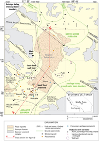
Generalized surficial geology, ground-water subbasins, selected piezometers and wells, faults, and geologic section, Edwards Air Force Base, California.
Figure 2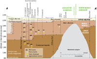
Generalized geologic section showing relation of lacustrine deposits to younger and older alluvium and aquifers, and arsenic and chromium concentrations for selected piezometers and production wells in the Lancaster and North Muroc subbasins, Edwards Air Force Base, California. Line of section is shown on figure 1.
Figure 3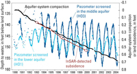
Aquifer-system compaction and water levels for 1990–2004 and InSAR measurements for four time periods during July 1993–May 2000 measured at the Holly site, Edwards Air Force Base, California.
Figure 4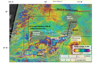
Contours showing subsidence (in feet) from about 1930 to 1992, and interferogram showing vertical land-surface change for August 9, 1997–October 23, 1999.
Figure 5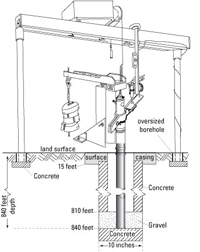
Borehole extensometer at the Holly site, Edwards Air Force Base, California.
Introduction
Edwards Air Force Base (EAFB) in southern California (fig. 1) has relied on ground water to meet its water-supply needs. The extraction of ground water has led to two major problems that can directly affect the mission of EAFB: declining water levels (more than 120 ft since the 1920s) and land subsidence, a gradual downward movement of the land surface (more than 4 ft since the late 1920s). As water levels decline, this valuable resource becomes depleted, thus requiring mitigating measures. Land subsidence has caused cracked (fissured) runways and accelerated erosion on Rogers lakebed.
In 1988, the U.S. Geological Survey (USGS), in cooperation with the U.S. Air Force, began investigations of the effects of declining water levels and land subsidence at EAFB and possible mitigation measures, such as the injection of imported surface water into the ground-water system. The cooperative investigations included data collection and analyses, numerical simulations of ground-water flow and land subsidence, and development of a preliminary simulation-optimization model. The results of these investigations indicate that the injection of imported water may help to control land subsidence; however, the potential ground-water-quality impacts are unknown.
Space shuttle prototype Enterprise approaching Rogers lakebed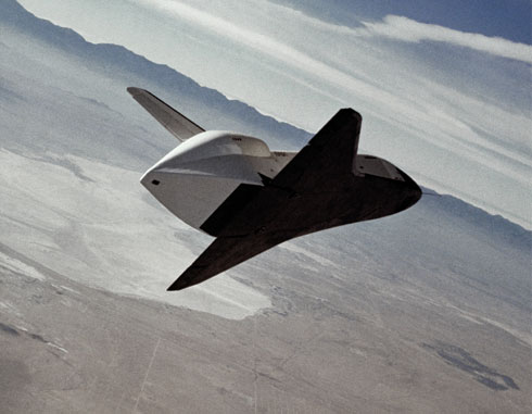
Subsidence fissure on Rogers lakebed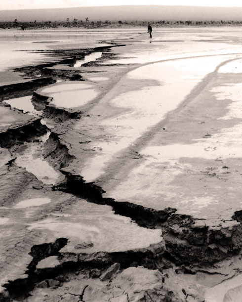
Data Collection and Analysis
Data collected during the investigations were obtained by surface and borehole geophysical surveys, ground-water-level measurements, aquifer-system compaction measurements, spirit-leveling and Global Positioning System (GPS) surveys, interferometric synthetic aperture radar (InSAR), and water-quality sampling. The following is a summary of activities and findings of the investigations.
• Gravity, seismic refraction, and surface-resistivity surveys were used to define the shape and structure of the bedrock and to identify potential aquifers and areas where pumping may cause additional land subsidence (fig. 2). Geologic logs and borehole geophysical surveys were used to define the aquifer system (the upper, middle, and lower aquifers) underlying EAFB (fig. 2). Most EAFB wells pump water from the middle aquifer.
• Historical water-level data were compiled, and indicated that ground-water levels have declined more than 120 ft since the 1920s.
• By 2002, the USGS constructed 56 piezometers (specialized wells used to measure water levels at specific depths) at 16 sites, and 3 extenso-meters (used to measure aquifer-system compaction to estimate land subsidence) at 2 sites (fig. 1).
• Twenty-four of the 56 piezometers and all 3 extensometers have been equipped to continuously measure and record ground-water levels and aquifer-system compaction, respectively. At the Holly site (fig. 1), water levels declined about 8 ft, and the aquifer system compacted about 0.7 ft for the period 1990−2004 (fig. 3). All the piezometers, as well as selected domestic, abandoned, and production wells, are measured at least twice (in spring and fall) every other year to monitor water levels throughout EAFB.
• A large-scale monitoring network of 85 benchmarks in Antelope Valley, which encompasses EAFB, was geodetically surveyed using GPS in 1992 to calculate historical subsidence and to enable precise measurements for future subsidence calculations. On EAFB, the greatest amount of calculated subsidence was 4 ft for the period 1930–92 at benchmark P1155 (fig. 4), near the intersection of Mercury Boulevard (Avenue B) and Lancaster Boulevard (120th Street East), near the south entrance to EAFB.
• InSAR is a technique that uses satellite-borne radar data acquired at different times to measure land-surface deformation over large areas, and was applied in 2004 to map and measure land subsidence on EAFB. The largest amount of InSAR-detected subsidence on EAFB was located near the southernmost tip of Rogers Lake, nearly 4 mi east of benchmark P1155, where the GPS survey showed the greatest historical subsidence on EAFB (fig. 4).
• Comparison of InSAR and extensometer data indicates that most of the compaction at the Holly site is likely occurring in the upper 840 ft of sediments. At the Holly site, nearly 0.4 ft of subsidence was detected from InSAR between July 1993 and May 2000, and 0.3 ft of aquifer-system compaction was measured by the extensometer for the same time period (fig. 3). The extensometer measures sediments that range 15 to 840 ft below land surface (fig. 5), whereas InSAR is not limited by depth.
• Water from 16 EAFB wells (production wells and piezometers) were tested for arsenic (As: III, V, and total) and chromium (Cr: III, VI, and total) in 2001. Total As concentrations were 3 to 58 micrograms per liter (µg/L) (most in the form of toxic As[V]), and total Cr concentrations were 0 to 12 µg/L (most in the form of toxic Cr[VI]) (fig. 2). Water from 4 production wells and 5 piezometers had total As concentrations greater than Environmental Protection Agency (EPA) maximum concentration limit (MCL) of 10 µg/L. Water from all wells had total Cr concentrations less than the EPA MCL of 100 µg/L
Ground-Water Flow and Aquifer-System Compaction Models
To better understand the physics of ground-water flow and aquifer-system compaction, the USGS developed a local-scale (one-dimensional vertical) model and a regional-scale (three-dimensional) model of ground-water flow and land subsidence of EAFB. The regional-scale model was incorporated into a preliminary simulation-optimization model that identified optimal conjunctive-use (using a combination of surface and ground water) strategies. Results of the models are listed below.
• Results from the local-scale model indicate that two thick clay layers—a regionally extensive lacustrine clay deposit and a localized clay-rich layer—account for more than 99 percent of the measured compaction at the Holly site. Model results also indicate that nearly all of the measured compaction is residual compaction; thus, compaction and land subsidence will persist into the future even without further water-level declines.
• Results from the regional-scale model indicate that the extensive faulting (see fault lines in fig. 1) in the region effectively compartmentalizes the ground-water basin and restricts ground-water flow. The compartmentalization combined with ground-water extraction results in subsidence, which causes the fissuring of Rogers lakebed.
• Results from the regional-scale model indicate that injection of 30 acre-ft/day of water into the middle aquifer at a well in the South Tract or South Base well fields may have resulted in a slower rate of subsidence than if injection did not occur. In addition, most of the injected water remained in proximity to the injection site because of the compartmentalization of the ground-water basin.
• A preliminary simulation-optimization model was developed that considered eight managed (production and injection) wells and imported surface water. The constraints in the model included meeting water demand, not exceeding the capacity of pumps and booster stations, and maintaining water levels. It was assumed that imported surface water was available for injection during the winter months (December−February). Results indicated that, over 5 years (2001–2005), optimal conjunctive-use strategies would reduce the amount of simulated subsidence by about 0.4 ft near the South Tract well field.
Future Directions
Continued ground-water flow and land subsidence studies at EAFB are warranted because persistent ground-water-level declines and land subsidence (fig. 3) will continue to threaten the mission of EAFB. A summary of possible future projects and their importance is listed below.
• Continued monitoring of ground-water levels, water quality, and land subsidence is critical because these data are the foundation for effective water-resources management.
• An additional extensometer anchored just below the thick lacustrine deposits at the Holly site to quantify the compaction of these deposits would be a valuable modification of the monitoring network.
• Routine Synthetic Aperture Radar data collection over EAFB is needed for establishing a sufficient data archive if future InSAR mapping of land subsidence is to be done.
• The numerical models should be refined and updated about every 5 years as new monitoring data are collected, to help EAFB decision-makers manage their water resources. Additionally, the software with which the numerical models were developed is continually being improved; therefore, future model updates could take advantage of these model improvements.
• Water-quality concerns regarding elevated arsenic concentrations can be addressed using the simulation-optimization model to test scenarios of mixing the affected ground water with other available water supplies to dilute, thereby lowering, the arsenic concentrations to levels less than the EPA MCL.
• An injection pilot project could be implemented at the South Tract well field to determine the feasibility of injecting large volumes of water into the ground-water system, and its impacts on ground-water quality and land subsidence. An artificial ground-water recharge program may be effective for increasing the water supply, taking maximum advantage of surface-water supplies when they are available, reducing the effect of additional overdraft on local ground-water resources, and controlling land subsidence.
Summary
Cooperative investigations between the USGS and EAFB since the late 1980s have described the geology, hydrogeology, geochemistry, and land subsidence, addressed optimal-conjunctive-use strategies with managed wells and imported surface water, and identified possible future investigative directions, including water-quality and land-subsidence mitigation strategies. Details of these investigations can be found in the reports listed in the References section.

