
|
|
|
||||
| Fact Sheet 2005-3113 |
At the request of Congress, the U.S. Geological Survey (USGS) is assessing the availability and use of the Nation's water resources to gain a clearer understanding of the status of our water resources and the land-use, water-use, and natural climatic trends that affect them. The goal of the National Assessment of Water Availability and Use Program is to improve our ability to forecast water availability for future economic and environmental uses. Simply put, the assessment will help characterize how much water we have now, how water availability is changing, and how much water we can expect to have in the future.
Currently (2005), the assessment is focused on the Great Lakes Basin (fig.1) to determine the best methods to evaluate water resources and to develop strategies for delivering information about water availability and use. Other water-resources regions will be added to the assessment as evaluation methods improve and as funding permits.
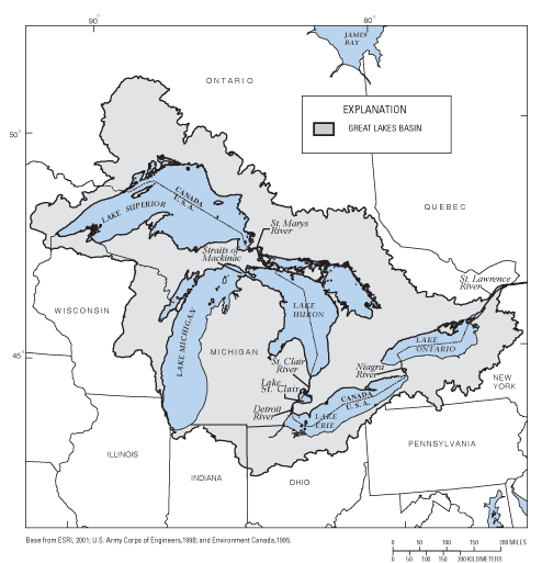
Figure 1. Location of the Great Lakes Basin in the United States and Canada.
The Great Lakes Basin, which encompasses Lakes Superior, Michigan, Huron, Erie, and Ontario (fig. 1), contains 95 percent of the fresh surface water in North America and 18 percent of the fresh surface water in the world. Ground water underlying the basin constitutes another large volume of freshwater. Humans, animals, and plants have adapted to this abundance in water resources. Yet, even in this water-rich area, water withdrawals, diversions, and use sometimes conflict with the needs of other users and ecosystems in the basin. For example, pumping of large water-supply wells in Wisconsin and Illinois has lowered ground-water levels in other wells in the area, reducing the yield of water to those wells and increasing pumping costs. Because the Great Lakes Basin contains so many communities, industries, and ecosystems that depend on present sources of water, and because competition for available water is intensifying, there is a need to quantify the region's water resources and the trends affecting them so that the potential for possible future water-use conflicts can be reduced or avoided.
In recent years, numerous government agencies, commerce, industry, and the general public all have expressed concern about potential large withdrawals of water within the Great Lakes Basin. In response, the Great Lakes States and Canadian Provinces signed an Annex to the Great Lakes Charter in 2001. The Annex commits the States and Provinces to science-based water-resources management. This commitment requires a more detailed understanding of the region's water resources and a synthesis of available data and information. The USGS Water Availability and Use assessment will provide information to fill this need for the U.S. part of the Great Lakes, their tributary streams, and the ground-water system that feeds the Great Lakes and its tributaries.
Water availability is a function of many factors, including the quantity and quality of water and the laws, regulations, economics, and environmental factors that control its use. The focus of the Great Lakes Basin study is on improving fundamental knowledge of the water balance of the basin, including the flows, storage, and water use by humans. An improved quantitative understanding of the basin's water balance not only provides key information about water quantity but also is a fundamental basis for many analyses of water quality and ecosystem health.
The water-level elevations of Lakes Michigan, Huron, Erie, and Ontario have varied about 6 feet since 1860, when accurate records of lake levels were first recorded. Water levels in Lake Superior varied about 3 feet during the same interval. Prehistoric variations were much greater and were strongly correlated with climate change. Changes in water levels of the Great Lakes constitute the largest changes in the amount of water in the region. The Great Lakes Basin study will summarize what is known about lake levels over the past 4,700 years. This analysis of lake levels will help put recent low lake levels into perspective, especially given the prospect of future global warming.
Streamflow maintains the water levels of the Great Lakes, nourishes ecosystem habitats, furnishes an essential raw material for a variety of industries, and carries away municipal wastes. Corresponding to these uses, streamflow availability is characterized in a variety of ways. For many uses, an appropriate measure of streamflow is the "minimum daily flow," which is especially important during droughts. For municipal wastes, a measure of the low flow of a stream quantifies water available for effluent dilution or "assimilative capacity" for which a treatment plant is designed. Other statistics characterize the seasonal distribution or persistence of streamflow. As a first step toward quantifying water availability, this project will assemble published statistics and compute relevant new statistics for streams now or previously gaged.
Trends in Streamflow.— Streamflow is affected by climatic factors (primarily precipitation) and watershed characteristics including human factors such as urbanization, stream regulation, and water diversions. Changes among these factors have altered the timing and rates of streamflow and, in some places (especially urban areas), have affected the magnitude and frequency of floods and low flows. In the past, these effects were either unrecognized or dispersed through a sparse, rural population and economy. Today, the economic, environmental, and political consequences of these streamflow changes could be far greater. Another aspect of quantifying future water availability is to quantify trends—especially those related to floods, droughts, and seasonal timing. If significant trends are detected, subsequent investigations may determine the cause. That information will help inform plans for future water use or watershed development and will help water-resource managers determine an appropriate network for monitoring streamflow in the basin.
Unmeasured streamflow. — The USGS currently measures streamflow for only about 70 percent of the U.S. part of the Great Lakes Basin. Streamflow for the remaining ungaged tributaries will be estimated for this study by means of regional regression and correlation techniques to determine the contribution of those areas to the water balance. This method will allow USGS scientists to make monthly estimates of total tributary streamflow to the Great Lakes, which will be provided online by way of USGS Web sites.
Ground water is a major natural resource in the Great Lakes Basin because it is, in effect, a large subsurface reservoir. Ground water discharges naturally to streams, lakes, and wetlands. It is also tapped for drinking water by many water suppliers and residents of the basin who do not use water directly from the lakes. Two major ground-water resource issues in the Great Lakes Basin are the amount of ground water available at a given location and the interaction of ground water with surface water. The Great Lakes Basin Water Availability and Use assessment will address various aspects of these ground-water issues.
Ground-water divides. — Ground-water divides are like watershed (land-surface) divides in that their location determines whether ground water will flow toward or away from one of the Great Lakes. Locations of ground-water divides in the uppermost aquifers underlying the basin commonly coincide with watershed divides. In deeper aquifers, however, ground-water divides may not coincide with watershed divides. Additionally, the location of ground-water divides can change if water is pumped from aquifers or if natural changes take place in the ground-water system. The Great Lakes Water Availability and Use assessment will delineate ground-water divides for most aquifers in the Great Lakes hydrologic system. This delineation will be a synthesis of data and information from previous and current regional and local studies. Where possible, areas where divides have shifted as a result of ground-water withdrawals or natural causes will be delineated.
Recharge. — Areal recharge is the primary source of water to the ground-water system; however, regional estimates of ground-water recharge in the Great Lakes Basin can differ substantially depending on the methods used. Consistent and accurate estimates are needed to understand how recharge to the ground-water system relates to water availability and use. Locally, areal recharge rates range from less than 1 inch per year to more than 20 inches per year on the basis of hydrograph analysis for large watersheds. The rates depend on precipitation and other climatic factors, in addition to watershed characteristics such as soil type. Seasonal, year-to-year, and decade-to-decade changes all can affect computed recharge rates. The recharge component of this assessment will evaluate new and existing methods to determine spatial recharge rates and trends in recharge over time.
Great Lakes Basin Hydrogeologic Summary. — Previous hydrogeologic studies in the Great Lakes Basin consist of a variety of regional and subregional investigations that were appropriate for a specific purpose but are difficult to synthesize into a broader view of water availability and use basinwide. As part of the hydrogeologic summary effort, results from published studies will be compiled, evaluated, and synthesized. Where possible, the amount of ground water in storage will be determined, and changes in ground-water storage through time will be assessed. In addition, water levels in observation wells with several decades of record will be analyzed for trends related to climatic factors. An analysis of available data will be done to determine if current monitoring of ground-water levels in the basin is adequate to support regional and national decisionmaking for effective water management. Analysis of ground-water monitoring programs will include data networks operated by Federal, state, and local agencies in the United States.
Application of ground-water-flow models is one of the most comprehensive ways to synthesize ground-water data and to analyze the response of a ground-water system to changes in the system, such as increased pumping rates, changes in pumping locations, changes in recharge, and climate variations. Regional models that simulate ground-water flow will greatly improve the overall understanding of ground-water conditions in the Great Lakes Basin and provide a quantitative framework to help manage water resources in ways consistent with the Great Lakes Charter Annex. Comprehensive ground-water-flow models are complex and time consuming to develop; therefore, the entire Great Lakes Basin could not be modeled for this study. Instead, a ground-water-flow model of the Lake Michigan subbasin is being developed because (1) the entire watershed is in the United States, and many datasets already are available within the USGS; (2) ground water is withdrawn from bedrock and glacial-deposit aquifers, both of which are important aquifer systems throughout the Great Lakes Basin; (3) important issues related to ground-water and surface-water interaction can be simulated with the model; (4) ground-water withdrawals in the Lake Michigan subbasin may affect the locations of ground-water divides with Lakes Superior, Huron, and Erie; and (5) problems caused by large-scale ground-water withdrawals have been documented in the subbasin. In addition, one or more separate models within the Lake Michigan subbasin will be developed specifically to simulate ground-water and surface-water interaction in smaller watersheds because this is an important component of the water balance not only here but elsewhere in the Great Lakes Basin. These models will be used to test new techniques for simulating the interactions of ground water and surface water at the appropriate scale.
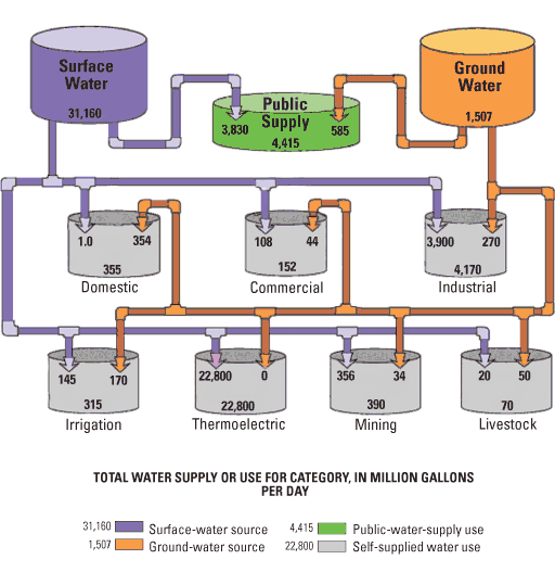
The USGS plans to compile water-use data (fig. 2) to assist Great Lakes Basin stakeholders in water-supply management efforts and to test compilation approaches that may have nationwide applicability. Preliminary discussions with state agencies have indicated that refinement of consumptive-use factors for all types of water use is the area of greatest interest and value to water-supply managers. Initial plans are to conduct a focused study on either (1) a small geographic area for a comprehensive understanding of consumptive use or (2) selected water-use categories (fig. 2) to refine the understanding of consumptive use for those categories basinwide. As an initial assessment of consumptive-use factors, the USGS has begun work on an annotated bibliography for consumptive-use coefficients in the Great Lakes and climatically similar regions.
For additional information about the USGS National Assessment of Water Availability and Use in the Great Lakes Basin, please contact:
Howard W. Reeves, Project Chief
USGS Michigan Water Science Center
6520 Mercantile Way, Suite 5
Lansing, MI 48911
Baedke, S.J., and Thomas, T.A., 2000, A 4,700-year record of lake level and isostasy for Lake Michigan; Journal of Great Lakes Research, v. 26, no. 4, p. 416#8211;426.
Council of Great Lakes Govenors, 2001, The Great Lakes Charter Annex, accessed October 27, 2005, at http://www.cglg.org/projects/water/Annex2001.pdf
National Oceanic and Atmospheric Administration, Great Lakes Water Levels, accessed October 27, 2005, at http://www.glerl.noaa.gov/data/now/wlevels/levels.html
Solley, W.B., Pierce, R.R., and Perlman, H.A., 1998, Estimated use of water in the United States in 1995: U.S. Geological Survey Circular 1200, 71 p.
Document Accessibility: Adobe Systems Incorporated has information about PDFs and the visually impaired. This information provides tools to help make PDF files accessible. These tools convert Adobe PDF documents into HTML or ASCII text, which then can be read by a number of common screen-reading programs that synthesize text as audible speech. In addition, an accessible version of Adobe Reader, which contains support for screen readers, is available. These tools and the accessible reader may be obtained free from Adobe at Adobe Access.
| AccessibilityFOIAPrivacyPolicies and Notices | |
 |
|