Fact Sheet 2006-3008
U.S. GEOLOGICAL SURVEY
Fact Sheet 2006-3008
Prepared in cooperation with the Arizona Department of Water Resources
By David W. Anning, Marilyn E. Flynn, and Margot Truini
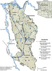
Figure 1. Physiography and location of water-level and well-log data for Detrital, Hualapai, and Sacramento Valleys, northwestern Arizona.
The Detrital, Hualapai, and Sacramento Valleys are broad, intermountain desert basins in Mohave County, northwestern Arizona, and are home to residents in the city of Kingman and several rural communities (fig. 1). Ground water is the primary source of water in these valleys and is essential for many economic and cultural activities. As in many parts of the Western United States, population growth in these valleys is substantial. From 2000 to 2004, the population of Kingman grew from 20,100 to 24,600an increase of 22 percent (Arizona Department of Economic Security, 2005). During the same time period, the population of Mohave County increased by 16 percent. Management of the available ground-water resources in these valleys guided by a comprehensive scientific understanding can help the growing communities to meet their needs in a sustainable manner.
In 2005, the U.S. Geological Survey (USGS) began an investigation of the hydrogeology of the Detrital, Hualapai, and Sacramento Valleys in cooperation with the Arizona Department of Water Resources (ADWR) as part of the Rural Watershed Initiative (RWI), a program established by the State of Arizona and managed by the ADWR. Other projects in the RWI program include investigations that began in 2005 in the middle San Pedro Basin and the Willcox and Douglas Basins, and investigations that began in 1999 in the Coconino Plateau, the Mogollon Highlands, and upper and middle Verde River study areas (http://az.water.usgs.gov/rwi-ii/).
The primary objective of this investigation is to improve the understanding of the hydrogeologic systems of Detrital, Hualapai, and Sacramento Valleys. This will be accomplished by:
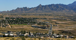
Figure 2. Desert vegetation and municipal development of the city of Kingman in Hualapai Valley.
The Detrital, Hualapai, and Sacramento Valleys are three distinct northwest-southeast trending alluvial basins in the Basin and Range Physiographic Province. The valley floors of Detrital and Hualapai Valleys generally slope downward to the north, and the valley floor of Sacramento Valley generally slopes downward to the south. Valley floor elevations range from about 3,500 ft near Kingman to about 500 ft at the mouth of Sacramento Wash. Mountain crests rise as much as 5,500 ft above valley floors, and the highest mountain in the study area is Hualapai Peak at 8,417 ft.
The climate of the valleys is arid to semiarid with hot summers and mild winters. Maximum daily temperatures in the valley floors typically are between 90 and 110ºF during the summer, and between 50 and 70ºF during the winter (Western Regional Climate Center, 2005). Annual precipitation on the valley floors ranges from about 5 to 10 in. Valley floors generally are covered with sparse desert vegetation (fig. 2) owing to the hot temperatures and little precipitation. Shrubs and trees cover mountain slopes and peaks in the higher elevations where temperatures are cooler and precipitation is greater. Annual precipitation in the mountains ranges from about 10 to 15 in.
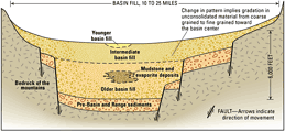
Figure 3. Generalized hydrogeologic section of the Detrital, Hualapai, and Sacramento Valleys (modified from Anderson and others, 1992).
The structural basins of Detrital, Hualapai, and Sacramento Valleys were formed during the Basin and Range disturbance, in which mountain ranges and basins were formed on adjacent sides of high-angle normal faults (fig. 3). The bedrock of the mountains that separate the valleys consists of granitic, metamorphic, sedimentary, and volcanic rocks (fig. 4). In most areas, the bedrock is relatively impermeable compared to the basin fill and forms barriers to ground-water movement in the basin-fill aquifer. The Grand Wash Cliffs along the eastern margin of the Hualapai Valley consist of Paleozoic sedimentary rocks that extend eastward and mark the boundary between the Colorado Plateau and Basin and Range Physiographic Provinces (Gillespie and Bentley, 1971).
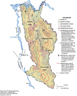
Figure 4. Bedrock geology and basin-fill characteristics in the Detrital, Hualapai, and Sacramento Valleys (modified from Richard and others, 2000, and Freethey and others, 1986).
The structural basins of the Detrital, Hualapai, and Sacramento Valleys contain basin fill (fig. 3) that ranges in thickness from a veneer along the mountain fronts to more than 5,000 ft in parts of each valley (Freethey and others, 1986; fig. 4). The basin fill is divided into older, intermediate, and younger hydrogeologic units (Gillespie and Bentley, 1971). Older basin fill is stratigraphically the oldest and deepest deposit, and consists of moderately consolidated fragments of rocks eroded from the surrounding mountains in a silty-clay or sandy matrix. The grain size decreases from pebble- and boulder-size fragments in the fanglomerate near the mountains to coarse sand and interbedded clay and silt in the basin center. Each valley has large areas of older basin fill where more than 55 percent of the sediments are fine grained (Freethey and others, 1986; fig. 4). In the northern parts of Hualapai and Detrital Valleys, massive evaporite deposits occur in the older basin fill (Gillespie and Bentley, 1971; Laney, 1979; Freethey and others, 1986; fig. 4). The composition of the intermediate basin fill is similar to that of the older basin fill, and the intermediate basin fill also becomes finer grained towards the basin center; however, the thickness of the intermediate basin fill is on the order of a few hundred feet rather than a few thousand feet. Thickness of the younger basin fill, which consists of Holocene piedmont, stream, and playa deposits, is also less than that of the older basin fill. In the northern parts of Detrital and Hualapai Valleys, the basin fill also includes clastic sediments, limestone, and basalt flows of the Muddy Creek and Chemehueve Formations (Laney, 1979).
Detrital, Hualapai, and Sacramento Valleys are drained by a network of streams that are intermittent or ephemeral owing to the dry climate. Detrital Wash, Hualapai Wash, and Sacramento Wash are the primary streams in their valleys and drain to the Colorado River. A topographic divide separates the northern and southern parts of Hualapai Valley. Truxton Wash, the only major stream that originates outside of the three valleys, drains part of the basin east of Hualapai Valley and flows westward into the southern part of the Hualapai Valley into Red Lake Playa (fig. 1). Streams generally flow only in response to regionally extensive winter storms or from spatially scattered summer thunderstorms. Runoff in mountain tributaries usually does not reach the valleys primary stream, but rather infiltrates the streambed sediments or evaporates. Many stream channels become poorly defined with distance from the mountain front owing to the lack of streamflow. Although the Colorado River forms a small part of the perimeter of each valley, it generally is not a significant water supply within the valleys.
Ground water from the basin-fill aquifer is the primary water supply for each of the three valleys. The older basin fill is the primary water-bearing deposit because intermediate and younger basin fill are above the water table in most areas. Most ground-water withdrawals in the valleys are for municipal and industrial uses; a small percentage of withdrawals is used for agriculture. The combined annual ground-water pumpage for the three valleys was about 6,600 acre-ft in 1991; by 2000, pumpage had nearly doubled to about 11,000 acre-ft (Tadayon, 2005). The combined annual recharge for the three valleys was estimated to be about 9,000 acre-ft (Freethey and Anderson, 1986), and ground-water storage was estimated to be about 13 million acre-ft (Arizona Department of Water Resources, 1994). Regional ground-water movement in the basin-fill aquifer generally is from the mountain fronts towards the valley center and then along the valley axis to the Colorado River. In general, depths to ground water are greatest in the upper parts of the valleys and decrease downgradient to within a few feet below the land surface near the Colorado River. The greatest depths to water are about 1,200 ft near the boundary between Detrital and Sacramento Valleys (Dillenburg, 1987; Rascona, 1991), and about 600 ft near Kingman in the Hualapai Valley (Remick, 1981).
Local ground water in consolidated rocks serves as a water supply in some areas, especially where rocks are faulted, fractured, and weathered (Gillespie and Bentley, 1971). In the Kingman area, volcanic rocks are locally permeable near two fault zones, and ground-water stored in the fractures has been used as part of the municipal water supply. Several springs issue from consolidated rocks and in some cases serve as water supplies for livestock and wildlife.
The Arizona Department of Environmental Quality has completed baseline ground-water quality studies in the Detrital (Towne, 2003) and Sacramento Valleys (Towne and Freark, 2001), and has begun a similar study in the Hualapai Valley. A total of 28 sites were sampled in Detrital Valley, and 48 sites were sampled in Sacramento Valley; sites included wells completed in basin-fill and consolidated-rock aquifers. In Detrital Valley, constituents for which 10 percent or more of the samples exceeded State or Federal water-quality standards include gross alpha, nitrate, total dissolved solids, sulfate, and manganese. In Sacramento Valley, constituents for which 10 percent or more of the samples exceeded such standards include gross alpha, nitrate, total dissolved solids, fluoride, chloride, and sulfate. In both valleys, dissolved-solids concentrations exceeded the standards more than any other constituent. On the basis of the results for all samples from each valley, the studies concluded that ground water in the Detrital and Sacramento Valleys generally met drinking-water standards.
Previous studies have provided a basic understanding about the hydrogeologic systems of Detrital, Hualapai, and Sacramento Valleys; however, several aspects need refinement and improved definition for optimal management of the ground-water resources. The study will begin with a compilation of existing information to develop a hydrogeologic database for the three valleys. In addition, field surveys will be conducted to update existing data for boreholes, wells, and water levels (fig. 1). Information gained in these efforts will be used to refine the initial conceptual models of the hydrogeologic systems of the valleys and to guide data-collection efforts in the following years. A preliminary assessment indicates that more hydrogeologic information and data are available for Hualapai and Sacramento Valleys than for Detrital Valley; therefore, data-collection and analysis efforts likely will be focused on Detrital Valley. Possible data-collection and analysis efforts include:
Anderson, T.W., Freethey, G.W., and Tucci, Patrick, 1992, Geohydrology and water resources of alluvial basins in south-central Arizona and adjacent states: U.S. Geological Survey Professional Paper 1406-B, 67 p. 3 pl.
Arizona Department of Economic Security, 2005, 2004 EstimatesPopulation growth, accessed November 21, 2005, at URL http://www.workforce.az.gov.us/.
Arizona Department of Water Resources, 1994, Arizona Water Resources Assessment, Volume I, Inventory and Analysis and Volume II, Hydrologic Summary: Arizona Department of Water Resources, 236 p.
Dillenburg, R.A., 1987, Map showing ground-water conditions in the Detrital Wash Basin Area, Mohave County, Arizona1987: Arizona Department of Water Resources Hydrologic Map Series Report Number 14, 1 pl., scale 1:125,000.
Freethey, G.W., and Anderson, T.W., 1986, Predevelopment hydrologic conditions in the alluvial basins of Arizona and adjacent parts of California and New Mexico: U.S. Geological Survey Hydrologic Investigations Atlas HA-664, 3 pl.
Freethey, G.W., Pool, D.R., Anderson, T.W., and Tucci, Patrick, 1986, Description and generalized distribution of aquifer materials in the alluvial basins of Arizona and adjacent parts of California and New Mexico: U.S. Geological Survey Hydrologic Investigations Atlas HA-663, 4 pl.
Gillespie, J.B., and Bentley, C.B., 1971, Geohydrology of Hualapai and Sacramento Valleys, Mohave County, Arizona: U.S. Geological Survey Water-Supply Paper 1899-H, 37 p. 2 pl. scale 1:125,000.
Laney, R.L., 1979, Geohydrologic reconnaissance of Lake Mead National Recreation AreaHoover Dam to Temple Bar, Arizona: U.S. Geological Survey Open-File Report 79689, 42 p.
Rascona, S.J., 1991, Map showing ground-water conditions in the Sacramento Valley Basin, Mohave County, Arizona1991: Arizona Department of Water Resources Hydrologic Map Series Report Number 21, 1 pl., scale 1:125,000.
Remick, W.H., 1981, Map showing ground-water conditions in the Hualapai Basin area, Mohave, Coconino, and Yavapai Counties, Arizona1980: Arizona Department of Water Resources Hydrologic Map Series Report Number 4, 1 pl., scale 1:125,000.
Richard, S.M., Reynolds, S.J., Spencer, J.E., and Pearthree, P.A., 2000, Geologic map of Arizona: Arizona Geological Survey, Map 35, 1 pl., scale 1:1,000,000.
Tadayon, Saeid, 2005, Water withdrawals for irrigation, municipal, mining, thermoelectric-power, and drainage uses in Arizona, outside of Active Management Areas, 19912000: U.S. Geological Survey Scientific Investigations Report 20045293, 28 p.
Towne, D.C., 2003, Ambient groundwater quality of the Detrital Valley BasinA 2002 Baseline Study: Arizona Department of Environmental Quality Open-File Report 200303, 65 p.
Towne, D.C., and Freark, M.C., 2001, Ambient groundwater quality of the Sacramento Valley BasinA 1999 Baseline Study: Arizona Department of Environmental Quality Open-File Report 200104, 78 p.
Western Regional Climate Center, 2005, Arizona Climate Summaries, 2005, accessed November 21, 2005, at URL http://www.wrcc.dri.edu/summary/climsmaz.html.
David W. Anning
U.S. Geological Survey
Arizona Water Science Center
Northern Arizona Programs
2255 North Gemini Drive
Flagstaff, Arizona, 86001
Email: dwanning@usgs.gov or visit
home page at http://az.water.usgs.gov
This report is available online in Portable Document Format (PDF). If you do not have the Adobe Acrobat PDF Reader, it is available for free download from Adobe Systems Incorporated.
Document Accessibility: Adobe Systems Incorporated has information about PDFs and the visually impaired. This information provides tools to help make PDF files accessible. These tools convert Adobe PDF documents into HTML or ASCII text, which then can be read by a number of common screen-reading programs that synthesize text as audible speech. In addition, an accessible version of Acrobat Reader 5.0 for Windows (English only), which contains support for screen readers, is available. These tools and the accessible reader may be obtained free from Adobe at Adobe Access.
For more information about USGS activities in Arizona, visit the USGS Arizona Water Science Center home page.

![]() U.S. Department of the Interior | U.S.
Geological Survey
U.S. Department of the Interior | U.S.
Geological Survey
Persistent URL: https://pubs.water.usgs.gov/fs20063008
Page Contact Information: Publications
Team
Page Last Modified:
Tuesday, 29-Nov-2016 17:21:28 EST
