Fact Sheet 2006–3012
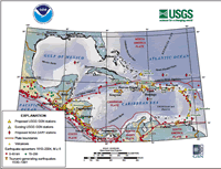 
The magnitude-9 Sumatra-Andaman Islands earthquake of December 26, 2004, increased awareness in the United States of the destructive hazard posed by earthquakes and tsunamis. The U.S. Government, working with international partners, is responding with a real-time system that will significantly improve global earthquake and tsunami monitoring. This fact sheet describes a project for earthquake and tsunami monitoring along a major portion of our vulnerable coastal regions, the Caribbean Sea, the Gulf of Mexico, and the Atlantic Ocean. The project is a result of collaboration between the U.S. Geological Survey and the National Oceanic and Atmospheric Administration (NOAA). |
Version 1.0 Posted April 2006
|
Part or all of this report is presented in Portable Document Format (PDF); the latest version of Adobe Acrobat Reader or similar software is required to view it. Download the latest version of Acrobat Reader, free of charge or go to access.adobe.com for free tools that allow visually impaired users to read PDF files.
